
| Memorials | : | 0 |
| Location | : | Sigerfjord, Sortland kommune, Norway |
| Coordinate | : | 68.6536880, 15.4920260 |
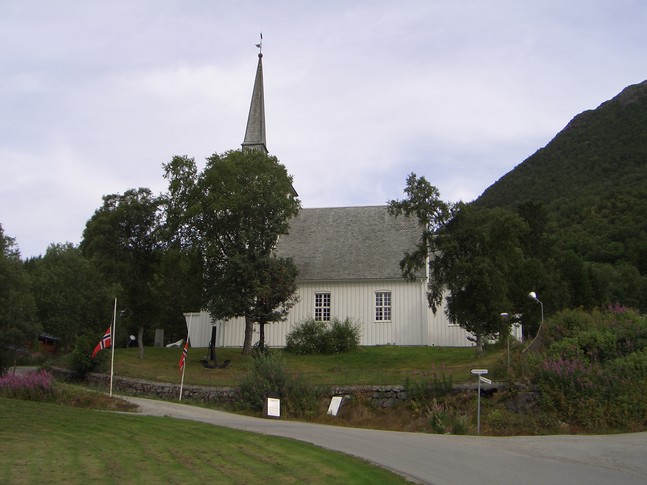
| Description | : | Sigerfjord Church (Norwegian: Sigerfjord kirke) is a parish church in the municipality of Sortland in Nordland county, Norway. It is located in the village of Sigerfjord. The church is part of the Sortland parish in the Vesterålen deanery in the Diocese of Sør-Hålogaland. The white wooden church was built in 1933 and designed by Harald Sund. The church seats about 280 people |
frequently asked questions (FAQ):
-
Where is Dalsand 2?
Dalsand 2 is located at Sigerfjord, Sortland kommune ,Nordland fylke ,Norway.
-
Dalsand 2 cemetery's updated grave count on graveviews.com?
0 memorials
-
Where are the coordinates of the Dalsand 2?
Latitude: 68.6536880
Longitude: 15.4920260
Nearby Cemetories:
1. Dalsand 1
Sortland, Sortland kommune, Norway
Coordinate: 68.6532370, 15.4928830
2. Sortland I
Sortland, Sortland kommune, Norway
Coordinate: 68.6982860, 15.4144810
3. Sortland II Kirke Gravplass
Sortland, Sortland kommune, Norway
Coordinate: 68.7004570, 15.4119250
4. Selnes
Sortland, Sortland kommune, Norway
Coordinate: 68.7093270, 15.4061230
5. Skagen Nye
Stokmarknes, Hadsel kommune, Norway
Coordinate: 68.5819300, 15.0285790
6. Skagen gamle Cemetery
Stokmarknes, Hadsel kommune, Norway
Coordinate: 68.5816850, 15.0112670
7. Steinlandsfjorden Kirkegård
Øksnes kommune, Norway
Coordinate: 68.8090191, 15.1886369
8. Hadsel Cemetery
Stokmarknes, Hadsel kommune, Norway
Coordinate: 68.5401200, 14.9895740
9. Skjolde
Andøy kommune, Norway
Coordinate: 68.8858256, 15.5001276
10. Øksnes Church Cemetery
Breidstrand, Øksnes kommune, Norway
Coordinate: 68.8775071, 14.9716038
11. Myre Cemetery
Myre, Øksnes kommune, Norway
Coordinate: 68.9225400, 15.0947900
12. Ora
Bo i Vesteralen, Bø kommune, Norway
Coordinate: 68.7426940, 14.6006420
13. Klo Kirkegård
Klo, Øksnes kommune, Norway
Coordinate: 68.9751010, 15.1798512
14. Bjørnskinn Nye Kirkegaard
Bjornskinn, Andøy kommune, Norway
Coordinate: 68.9913670, 15.6408360
15. Sørvik Churchyard, Island of Hinnøy
Harstad kommune, Norway
Coordinate: 68.6828290, 16.5295080
16. Rødskjær
Harstad kommune, Norway
Coordinate: 68.5770000, 16.5240000
17. Langenes Church Cemetery
Langenes, Øksnes kommune, Norway
Coordinate: 69.0189000, 15.1559000
18. Duken
Bo i Vesteralen, Bø kommune, Norway
Coordinate: 68.6226250, 14.4371840
19. Husjord Gravplass
Øksnes kommune, Norway
Coordinate: 69.0184190, 15.1380521
20. Sanden Kirkegård
Hadsel kommune, Norway
Coordinate: 68.4336537, 14.6077327
21. Harstad Cemetery
Harstad kommune, Norway
Coordinate: 68.8057550, 16.5113620
22. Evenskjer Old Cemetery
Evenskjer, Skånland kommune, Norway
Coordinate: 68.5828340, 16.5804890
23. Ånes
Anes, Andøy kommune, Norway
Coordinate: 69.0606054, 15.7861929
24. Trondenes Church
Harstad kommune, Norway
Coordinate: 68.8235890, 16.5619750