
| Memorials | : | 0 |
| Location | : | Harstad kommune, Norway |
| Coordinate | : | 68.8235890, 16.5619750 |
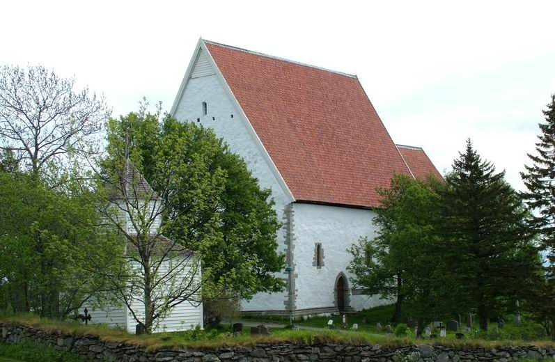
| Description | : | Trondenes Church (Norwegian: Trondenes kirke) is the northernmost medieval stone church of Norway. It is a parish church in the municipality of Harstad in Troms county, Norway. It is located in the village of Trondenes. The church is part of the Trondenes parish in the Trondenes deanery in the Diocese of Nord-Hålogaland. Though frequently mentioned as a 13th-century church, dating based on dendrochronology places its completion shortly after 1434. Compared to the other ten north Norwegian Medieval stone churches, Trondenes church is well preserved and the exterior is close to the original state. The nave is 22.6 metres (74 ft) long... Read More |
frequently asked questions (FAQ):
-
Where is Trondenes Church?
Trondenes Church is located at Harstad kommune ,Troms fylke ,Norway.
-
Trondenes Church cemetery's updated grave count on graveviews.com?
0 memorials
-
Where are the coordinates of the Trondenes Church?
Latitude: 68.8235890
Longitude: 16.5619750
Nearby Cemetories:
1. Harstad Cemetery
Harstad kommune, Norway
Coordinate: 68.8057550, 16.5113620
2. Sørvik Churchyard, Island of Hinnøy
Harstad kommune, Norway
Coordinate: 68.6828290, 16.5295080
3. Evenskjer Old Cemetery
Evenskjer, Skånland kommune, Norway
Coordinate: 68.5828340, 16.5804890
4. Rødskjær
Harstad kommune, Norway
Coordinate: 68.5770000, 16.5240000
5. Dverberg Church Cemetery
Dverberg, Andøy kommune, Norway
Coordinate: 69.1140238, 15.9815818
6. Ånes
Anes, Andøy kommune, Norway
Coordinate: 69.0606054, 15.7861929
7. Evenes
Evenes kommune, Norway
Coordinate: 68.4600630, 16.6985140
8. Bjørnskinn Nye Kirkegaard
Bjornskinn, Andøy kommune, Norway
Coordinate: 68.9913670, 15.6408360
9. Skjolde
Andøy kommune, Norway
Coordinate: 68.8858256, 15.5001276
10. Tjelle kirkegård
Narvik kommune, Norway
Coordinate: 68.4172788, 16.6175708
11. Dalsand 1
Sortland, Sortland kommune, Norway
Coordinate: 68.6532370, 15.4928830
12. Dalsand 2
Sigerfjord, Sortland kommune, Norway
Coordinate: 68.6536880, 15.4920260
13. Selnes
Sortland, Sortland kommune, Norway
Coordinate: 68.7093270, 15.4061230
14. Sortland I
Sortland, Sortland kommune, Norway
Coordinate: 68.6982860, 15.4144810
15. Sortland II Kirke Gravplass
Sortland, Sortland kommune, Norway
Coordinate: 68.7004570, 15.4119250
16. Lavangen Church
Lavangen, Tromsø kommune, Norway
Coordinate: 68.7722630, 17.8021490
17. Bjerkvik Kirkegaard
Bjerkvik, Narvik kommune, Norway
Coordinate: 68.5480347, 17.5637703
18. Salangen Cemetery
Sjovegan, Salangen kommune, Norway
Coordinate: 68.8700800, 17.8569200
19. Steinlandsfjorden Kirkegård
Øksnes kommune, Norway
Coordinate: 68.8090191, 15.1886369
20. Ballangen New Cemetery
Ballangen, Ballangen kommune, Norway
Coordinate: 68.3351370, 16.8185150
21. Haakvik Cemetery
Narvik kommune, Norway
Coordinate: 68.4052450, 17.3093490
22. Narvik New Cemetery
Narvik, Narvik kommune, Norway
Coordinate: 68.4434400, 17.4507300
23. Håkvik kirkegård
Hakvik, Narvik kommune, Norway
Coordinate: 68.4049978, 17.3102055
24. Narvik Old Cemetery
Narvik, Narvik kommune, Norway
Coordinate: 68.4419900, 17.4526100