
| Memorials | : | 7 |
| Location | : | Boyle County, USA |
| Coordinate | : | 37.7101021, -84.7448883 |
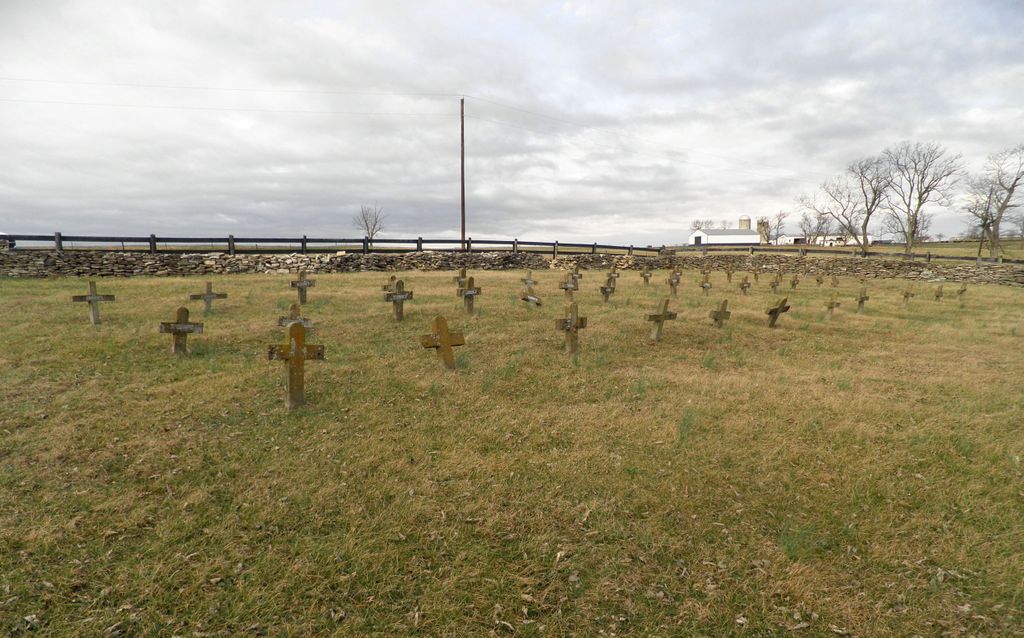
| Description | : | DARNELL CEMETERY This cemetery is on Northpoint Training Center (State Prison) property which is 5 miles north of Danville, Kentucky, off Ky Hwy 33, Shakertown Road (North Third Street). During world War II, this was Darnell General Hospital, a Federal facility which was later sold to the State of Kentucky and converted to a State Mental Hospital. It was briefly Danville Youth Devopment Center, a juvenile detention center. The 1940 Census calls it a Reformatory. A Cremation Oven stood near the grave yard at least until 1982 when it became a state prison. There are only two burial sites with... Read More |
frequently asked questions (FAQ):
-
Where is Darnell Hospital Cemetery?
Darnell Hospital Cemetery is located at Boyle County ,Kentucky , 40310USA.
-
Darnell Hospital Cemetery cemetery's updated grave count on graveviews.com?
7 memorials
-
Where are the coordinates of the Darnell Hospital Cemetery?
Latitude: 37.7101021
Longitude: -84.7448883
Nearby Cemetories:
1. Robinson Road Cemetery
Mercer County, USA
Coordinate: 37.7374992, -84.7444000
2. Carry Nation - Moore Family Cemetery
Bryantsville, Garrard County, USA
Coordinate: 37.7095870, -84.7033810
3. Meauxtown African American Cemetery
Danville, Boyle County, USA
Coordinate: 37.6768750, -84.7431280
4. Bonta and Sallee Family Graveyard
Burgin, Mercer County, USA
Coordinate: 37.7293500, -84.7098000
5. Proctor Cemetery
Mercer County, USA
Coordinate: 37.7372017, -84.7185974
6. Mayes Cemetery
Burgin, Mercer County, USA
Coordinate: 37.7270770, -84.6964360
7. Burgin Memorial Gardens
Burgin, Mercer County, USA
Coordinate: 37.7463989, -84.7743988
8. Davistown African American Baptist Church Cemetery
Davistown, Garrard County, USA
Coordinate: 37.6858240, -84.6979590
9. Stony Point Cemetery
Danville, Boyle County, USA
Coordinate: 37.6681900, -84.7242100
10. Bonta Family Graveyard
Burgin, Mercer County, USA
Coordinate: 37.7418900, -84.7044400
11. Needmore African American Cemetery
Little Needmore, Boyle County, USA
Coordinate: 37.6608600, -84.7343500
12. Saint James Cemetery
Buena Vista, Garrard County, USA
Coordinate: 37.7493400, -84.7020100
13. Swope Cemetery
Bryantsville, Garrard County, USA
Coordinate: 37.7094460, -84.6777770
14. Banta Graveyard
Harrodsburg, Mercer County, USA
Coordinate: 37.7138700, -84.8128250
15. Lander-Walden Cemetery
Burgin, Mercer County, USA
Coordinate: 37.7501240, -84.7923230
16. Pleasant Grove Christian Church Cemetery
Garrard County, USA
Coordinate: 37.6879590, -84.6745640
17. Bellevue Cemetery
Danville, Boyle County, USA
Coordinate: 37.6521988, -84.7686005
18. Danville National Cemetery
Danville, Boyle County, USA
Coordinate: 37.6515656, -84.7689667
19. Smith Cemetery
Lancaster, Garrard County, USA
Coordinate: 37.7199940, -84.6675000
20. Spillman Family Graveyard
Buena Vista, Garrard County, USA
Coordinate: 37.7546430, -84.6853340
21. Campbell Graveyard
Mercer County, USA
Coordinate: 37.7586400, -84.7999300
22. Kays Farm Cemetery
Bryantsville, Garrard County, USA
Coordinate: 37.7237500, -84.6639060
23. Rochester Cemetery
Danville, Boyle County, USA
Coordinate: 37.6443120, -84.7632430
24. Majors Cemetery
Bryantsville, Garrard County, USA
Coordinate: 37.7708080, -84.7055450