
| Memorials | : | 0 |
| Location | : | Yuma County, USA |
| Coordinate | : | 32.7558500, -114.3652170 |
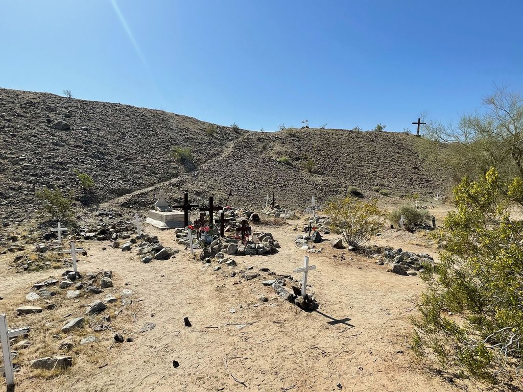
| Description | : | Dome / Gila City Cemetery. Located on the south bank of the Gila River about 20 miles east of Yuma, the site was first known as Swiveler's Station in 1857, then a stop along the old Butterfield Overland Mail route. After gold was discovered nearby in 1858 Gila City sprang up around the station. The "Gila City" post office operated from December 24, 1858, until July 14, 1863. A severe flood early in 1862 destroyed most of the town. The placers and the town were all but abandoned by late 1865. With the arrival of the railroad an attempt to... Read More |
frequently asked questions (FAQ):
-
Where is Dome Cemetery?
Dome Cemetery is located at Route of Butterfield Stage Yuma County ,Arizona , 85365USA.
-
Dome Cemetery cemetery's updated grave count on graveviews.com?
0 memorials
-
Where are the coordinates of the Dome Cemetery?
Latitude: 32.7558500
Longitude: -114.3652170


Nearby Cemetories:
1. Saint John Neumann Catholic Church Columbarium
Yuma, Yuma County, USA
Coordinate: 32.6550700, -114.4368200
2. Sunset Vista Funeral Home & Cemetery
Yuma, Yuma County, USA
Coordinate: 32.6548000, -114.4386000
3. Gloria de Cristo Lutheran Church Columbarium
Yuma, Yuma County, USA
Coordinate: 32.6553600, -114.4404100
4. Laguna Cemetery
Laguna, Yuma County, USA
Coordinate: 32.8017113, -114.4963377
5. Potholes Cemetery
Bard, Imperial County, USA
Coordinate: 32.8171997, -114.5119019
6. Christ Lutheran Church Columbarium
Yuma, Yuma County, USA
Coordinate: 32.6813300, -114.5940800
7. Fort Yuma Post
Winterhaven, Imperial County, USA
Coordinate: 32.7387790, -114.6142540
8. Quechan Indian Cemetery
Winterhaven, Imperial County, USA
Coordinate: 32.7395962, -114.6147566
9. Yuma Territorial Prison State Historic Park
Yuma, Yuma County, USA
Coordinate: 32.7262000, -114.6134000
10. Wellton Memorial Cemetery
Wellton, Yuma County, USA
Coordinate: 32.6536000, -114.1420000
11. Yuma Pioneer Cemetery
Yuma, Yuma County, USA
Coordinate: 32.7042007, -114.6177979
12. Desert Lawn Memorial Park
Yuma, Yuma County, USA
Coordinate: 32.7016983, -114.6175003
13. Faith Lutheran Church Columbarium
Yuma, Yuma County, USA
Coordinate: 32.6862500, -114.6284900
14. Saint Pauls Episcopal Church Columbarium
Yuma, Yuma County, USA
Coordinate: 32.6992000, -114.6380000
15. Trinity United Methodist Church Columbarium
Yuma, Yuma County, USA
Coordinate: 32.6726400, -114.6290600
16. Butterfield Stage Station Burial Site
Roll, Yuma County, USA
Coordinate: 32.7101640, -114.0098830
17. Picacho Mine Cemetery
Picacho, Imperial County, USA
Coordinate: 32.9665000, -114.6375500
18. East Cocopah Indian Reservation Cemetery
Somerton, Yuma County, USA
Coordinate: 32.5743500, -114.6740700
19. Panteón Ejido Culiacán
Vicente Guerrero, Ensenada Municipality, Mexico
Coordinate: 32.7119410, -114.7548960
20. Picacho Cemetery
Imperial County, USA
Coordinate: 33.0207280, -114.6177150
21. West Cocopah Indian Reservation Cemetery
Somerton, Yuma County, USA
Coordinate: 32.6152000, -114.7638390
22. Ogilby Cemetery
Ogilby, Imperial County, USA
Coordinate: 32.8152300, -114.8389400
23. Hedges Cemetery
Imperial County, USA
Coordinate: 32.8843994, -114.8302994
24. Panteón Municipal Consejo
San Luis Rio Colorado, San Luis Río Colorado Municipality, Mexico
Coordinate: 32.4619110, -114.7321960