
| Memorials | : | 0 |
| Location | : | Imperial County, USA |
| Coordinate | : | 33.0207280, -114.6177150 |
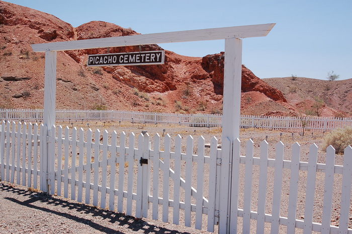
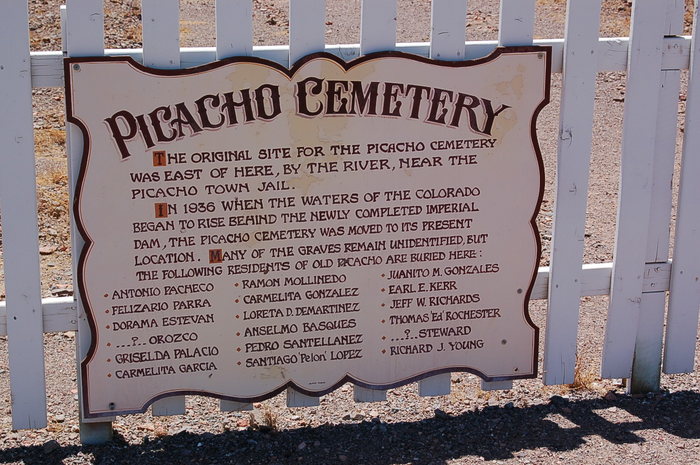
| Description | : | In 1936 when the waters of the Colorado began to rise behind the newly completed Imperial Dam, the Picacho Cemetery was moved to its present location. Many of the graves remain unidentified, but 18 are identified on the entrance sign board to the cemetery. Picacho Cemetery is located within the borders of the Picacho State Recreation Area along the Colorado River. Access from Winterhaven is along a 24-mile stretch of the Picacho Road, which is paved only for the first six miles. The next 18 miles is unpaved gravel usually passable for vehicles if not flooded by summer showers. Similar... Read More |
frequently asked questions (FAQ):
-
Where is Picacho Cemetery?
Picacho Cemetery is located at Imperial County ,California ,USA.
-
Picacho Cemetery cemetery's updated grave count on graveviews.com?
0 memorials
-
Where are the coordinates of the Picacho Cemetery?
Latitude: 33.0207280
Longitude: -114.6177150
Nearby Cemetories:
1. Picacho Mine Cemetery
Picacho, Imperial County, USA
Coordinate: 32.9665000, -114.6375500
2. Potholes Cemetery
Bard, Imperial County, USA
Coordinate: 32.8171997, -114.5119019
3. Hedges Cemetery
Imperial County, USA
Coordinate: 32.8843994, -114.8302994
4. Laguna Cemetery
Laguna, Yuma County, USA
Coordinate: 32.8017113, -114.4963377
5. Ogilby Cemetery
Ogilby, Imperial County, USA
Coordinate: 32.8152300, -114.8389400
6. Quechan Indian Cemetery
Winterhaven, Imperial County, USA
Coordinate: 32.7395962, -114.6147566
7. Fort Yuma Post
Winterhaven, Imperial County, USA
Coordinate: 32.7387790, -114.6142540
8. Yuma Territorial Prison State Historic Park
Yuma, Yuma County, USA
Coordinate: 32.7262000, -114.6134000
9. Cibola Cemetery
Cibola, La Paz County, USA
Coordinate: 33.3153450, -114.6641800
10. Yuma Pioneer Cemetery
Yuma, Yuma County, USA
Coordinate: 32.7042007, -114.6177979
11. Desert Lawn Memorial Park
Yuma, Yuma County, USA
Coordinate: 32.7016983, -114.6175003
12. Saint Pauls Episcopal Church Columbarium
Yuma, Yuma County, USA
Coordinate: 32.6992000, -114.6380000
13. Panteón Ejido Culiacán
Vicente Guerrero, Ensenada Municipality, Mexico
Coordinate: 32.7119410, -114.7548960
14. Faith Lutheran Church Columbarium
Yuma, Yuma County, USA
Coordinate: 32.6862500, -114.6284900
15. Dome Cemetery
Yuma County, USA
Coordinate: 32.7558500, -114.3652170
16. Christ Lutheran Church Columbarium
Yuma, Yuma County, USA
Coordinate: 32.6813300, -114.5940800
17. Trinity United Methodist Church Columbarium
Yuma, Yuma County, USA
Coordinate: 32.6726400, -114.6290600
18. Gloria de Cristo Lutheran Church Columbarium
Yuma, Yuma County, USA
Coordinate: 32.6553600, -114.4404100
19. Sunset Vista Funeral Home & Cemetery
Yuma, Yuma County, USA
Coordinate: 32.6548000, -114.4386000
20. Saint John Neumann Catholic Church Columbarium
Yuma, Yuma County, USA
Coordinate: 32.6550700, -114.4368200
21. West Cocopah Indian Reservation Cemetery
Somerton, Yuma County, USA
Coordinate: 32.6152000, -114.7638390
22. Panteón de Ejido Mérida
Merida, Mexicali Municipality, Mexico
Coordinate: 32.6518250, -114.9065090
23. East Cocopah Indian Reservation Cemetery
Somerton, Yuma County, USA
Coordinate: 32.5743500, -114.6740700
24. Panteón Ejidal Morelos Arnulfo Meza Villegas
Cuervos, Mexicali Municipality, Mexico
Coordinate: 32.6159060, -114.8566100