| Memorials | : | 0 |
| Location | : | Nordhausen, Landkreis Nordhausen, Germany |
| Coordinate | : | 51.5355000, 10.7485560 |
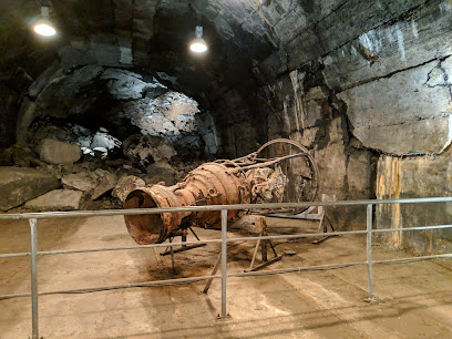
| Description | : | The Dora-Mittelbau (also known as Dora-Nordhausen or Nordhausen) camp was established in Germany near the Harz Mountains, north of the town of Nordhausen. It was initially a subcamp of Buchenwald. In 1943, prisoners from Buchenwald were sent there to build large underground factories and development facilities for the V-2 missile. In October 1944, the SS made Dora-Mittelbau an independent concentration camp with more than 30 subcamps of its own. Until the spring of 1944, prisoners were usually kept underground, deprived of daylight and fresh air, and enclosed in unstable tunnels. The mortality rate was higher than at most other concentration... Read More |
frequently asked questions (FAQ):
-
Where is Dora-Mittelbau Concentration Camp?
Dora-Mittelbau Concentration Camp is located at Kohnsteinweg 20 Nordhausen, Landkreis Nordhausen ,Thüringen , 99734Germany.
-
Dora-Mittelbau Concentration Camp cemetery's updated grave count on graveviews.com?
0 memorials
-
Where are the coordinates of the Dora-Mittelbau Concentration Camp?
Latitude: 51.5355000
Longitude: 10.7485560
Nearby Cemetories:
1. Nordhäuser Dom
Landkreis Nordhausen, Germany
Coordinate: 51.5041670, 10.7902780
2. Cyriaci-Kapelle
Nordhausen, Landkreis Nordhausen, Germany
Coordinate: 51.5002780, 10.7913890
3. Nordhausen Hauptfriedhof
Nordhausen, Landkreis Nordhausen, Germany
Coordinate: 51.4966580, 10.8179897
4. FriedWald Südharz
Bad Sachsa, Landkreis Osterode am Harz, Germany
Coordinate: 51.5926120, 10.5759870
5. Friedhof Tettenborn
Tettenborn, Landkreis Osterode am Harz, Germany
Coordinate: 51.5613956, 10.5544823
6. St. Martinikirche Stolberg
Stolberg, Landkreis Mansfeld-Südharz, Germany
Coordinate: 51.5737990, 10.9544140
7. Friedhof Görsbach
Gorsbach, Landkreis Nordhausen, Germany
Coordinate: 51.4637978, 10.9388145
8. Gemeindefriedhof Stiege
Stiege, Landkreis Harz, Germany
Coordinate: 51.6628358, 10.8808012
9. Gedenkstätte beider Weltkriege
Stiege, Landkreis Harz, Germany
Coordinate: 51.6632215, 10.8839660
10. Kirche - Zur Hilfe Gottes
Stiege, Landkreis Harz, Germany
Coordinate: 51.6664991, 10.8888544
11. Berga Friedhof
Landkreis Greiz, Germany
Coordinate: 51.4592480, 11.0010050
12. Güntersberge Gemeindefriedhof
Quedlinburg, Landkreis Harz, Germany
Coordinate: 51.6480260, 10.9836160
13. Friedhof Rübeland
Rübeland, Landkreis Harz, Germany
Coordinate: 51.7519527, 10.8478223
14. Sankt Andreasberg
Sankt Andreasberg, Landkreis Goslar, Germany
Coordinate: 51.7112300, 10.5221000
15. St. John the Baptist Cemetery
Holungen, Landkreis Eichsfeld, Germany
Coordinate: 51.4946056, 10.3921647
16. Tierfriedhof Am Vogelsang
Bad Lauterberg im Harz, Landkreis Osterode am Harz, Germany
Coordinate: 51.6152492, 10.4001294
17. Friedhof Kirchworbis
Kirchworbis, Landkreis Eichsfeld, Germany
Coordinate: 51.4080067, 10.3992656
18. Kriegsdenkmal Hüttenode
Hüttenrode, Landkreis Harz, Germany
Coordinate: 51.7692395, 10.9042280
19. Friedhof Hüttenrode
Hüttenrode, Landkreis Harz, Germany
Coordinate: 51.7736573, 10.9068782
20. Friedhof Niederorschel
Niederorschel, Landkreis Eichsfeld, Germany
Coordinate: 51.3668810, 10.4315180
21. Ehrenfriedhof Brocken
Sankt Andreasberg, Landkreis Goslar, Germany
Coordinate: 51.7838100, 10.5547600
22. Ev. Friedhof Herzberg am Harz
Herzberg am Harz, Landkreis Osterode am Harz, Germany
Coordinate: 51.6493900, 10.3370200
23. Nicolaikirche
Herzberg am Harz, Landkreis Osterode am Harz, Germany
Coordinate: 51.6546800, 10.3401000
24. Kath. Friedhof Herzberg am Harz
Herzberg am Harz, Landkreis Osterode am Harz, Germany
Coordinate: 51.6500300, 10.3362000

