
| Memorials | : | 0 |
| Location | : | Lubars, Reinickendorf, Germany |
| Coordinate | : | 52.6207230, 13.3573860 |
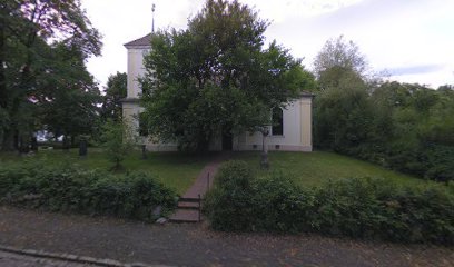
| Description | : | DEFUNCT Lübars used to be an independent village, but since 1920 is part pf the city of Berlin. There has been a cemetery at this location since the Middle Ages. The old church building dates back to the 15th century. Burials are no longer taking place. Since 1896 the community uses the new cemetery (Friedhof Lübars) at Zabel-Krüger Damm 176. A lot of markers have been lost over time. The last known burial here was in 1906. A World War I Memorial Plaque remembers the fallen sons of the village. Most of them are not buried here. |
frequently asked questions (FAQ):
-
Where is Dorfkirchhof Alt-Lübars?
Dorfkirchhof Alt-Lübars is located at Alt-Lübars 12 Lubars, Reinickendorf ,Berlin , 13469Germany.
-
Dorfkirchhof Alt-Lübars cemetery's updated grave count on graveviews.com?
0 memorials
-
Where are the coordinates of the Dorfkirchhof Alt-Lübars?
Latitude: 52.6207230
Longitude: 13.3573860
Nearby Cemetories:
1. Friedhof Lübars
Lubars, Reinickendorf, Germany
Coordinate: 52.6153220, 13.3490750
2. Friedhof Pankow VIII
Blankenfelde, Pankow, Germany
Coordinate: 52.6171850, 13.3797330
3. Friedhof Blankenfelde
Blankenfelde, Pankow, Germany
Coordinate: 52.6188084, 13.3898162
4. Neuer Friedhof Rosenthal
Rosenthal, Pankow, Germany
Coordinate: 52.6054580, 13.3782160
5. Friedhof
Glienicke, Landkreis Oberhavel, Germany
Coordinate: 52.6300022, 13.3205898
6. Dorfkirchhof Rosenthal
Rosenthal, Pankow, Germany
Coordinate: 52.5995010, 13.3780000
7. Friedhof Pankow VII
Rosenthal, Pankow, Germany
Coordinate: 52.5941315, 13.3658123
8. Friedhof Hermsdorf I
Hermsdorf, Reinickendorf, Germany
Coordinate: 52.6108017, 13.3031292
9. Dorfkirchhof Alt-Wittenau
Wittenau, Reinickendorf, Germany
Coordinate: 52.5922430, 13.3254560
10. Friedhof Wittenau
Wittenau, Reinickendorf, Germany
Coordinate: 52.5907960, 13.3222960
11. Friedhof Nordend Bereich Frieden-Himmelfahrt
Pankow, Pankow, Germany
Coordinate: 52.5951090, 13.4041340
12. Friedhof Nordend Bereich Gethsemane
Pankow, Pankow, Germany
Coordinate: 52.5934820, 13.4035420
13. Friedhof Hermsdorf II
Hermsdorf, Reinickendorf, Germany
Coordinate: 52.6268044, 13.2910538
14. Sowjetisches Ehrenmal Schönholzer Heide
Pankow, Germany
Coordinate: 52.5811581, 13.3733418
15. Martin-Luther-Friedhof
Tegel, Reinickendorf, Germany
Coordinate: 52.6009850, 13.2967830
16. Kriegsgräberstätte Reinickendorf
Reinickendorf, Reinickendorf, Germany
Coordinate: 52.5769726, 13.3512016
17. Friedhof Pankow IX
Franzosisch Buchholz, Pankow, Germany
Coordinate: 52.6086030, 13.4286500
18. Friedhof Pankow V
Niederschonhausen, Pankow, Germany
Coordinate: 52.5777140, 13.3790730
19. Dorfkirchhof Alt-Reinickendorf
Reinickendorf, Reinickendorf, Germany
Coordinate: 52.5750910, 13.3519580
20. Friedhof Tegel Am Fliesstal
Tegel, Reinickendorf, Germany
Coordinate: 52.5967522, 13.2880278
21. Friedhof Pankow IV
Niederschonhausen, Pankow, Germany
Coordinate: 52.5835540, 13.4089620
22. Friedhof Tegel Am Nordgraben
Tegel, Reinickendorf, Germany
Coordinate: 52.5935330, 13.2898950
23. Friedhof Pankow VI
Pankow, Pankow, Germany
Coordinate: 52.5746100, 13.3861380
24. Friedhof Reinickendorf II
Reinickendorf, Reinickendorf, Germany
Coordinate: 52.5716553, 13.3404284