
| Memorials | : | 0 |
| Location | : | Teltow, Landkreis Potsdam-Mittelmark, Germany |
| Coordinate | : | 52.3746670, 13.2679067 |
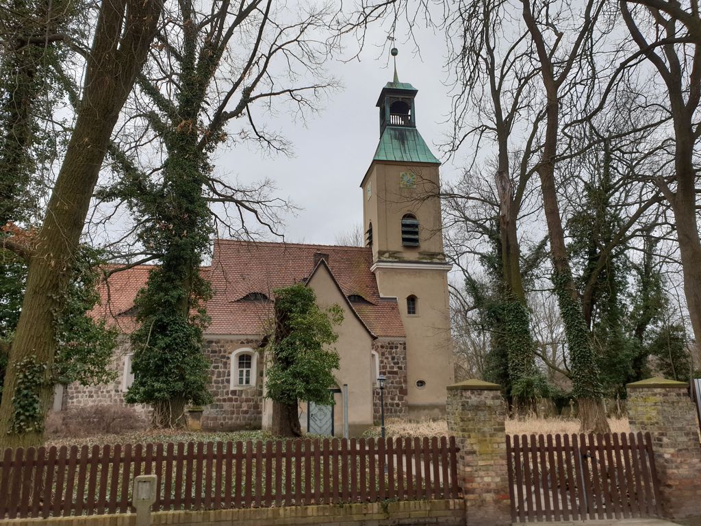
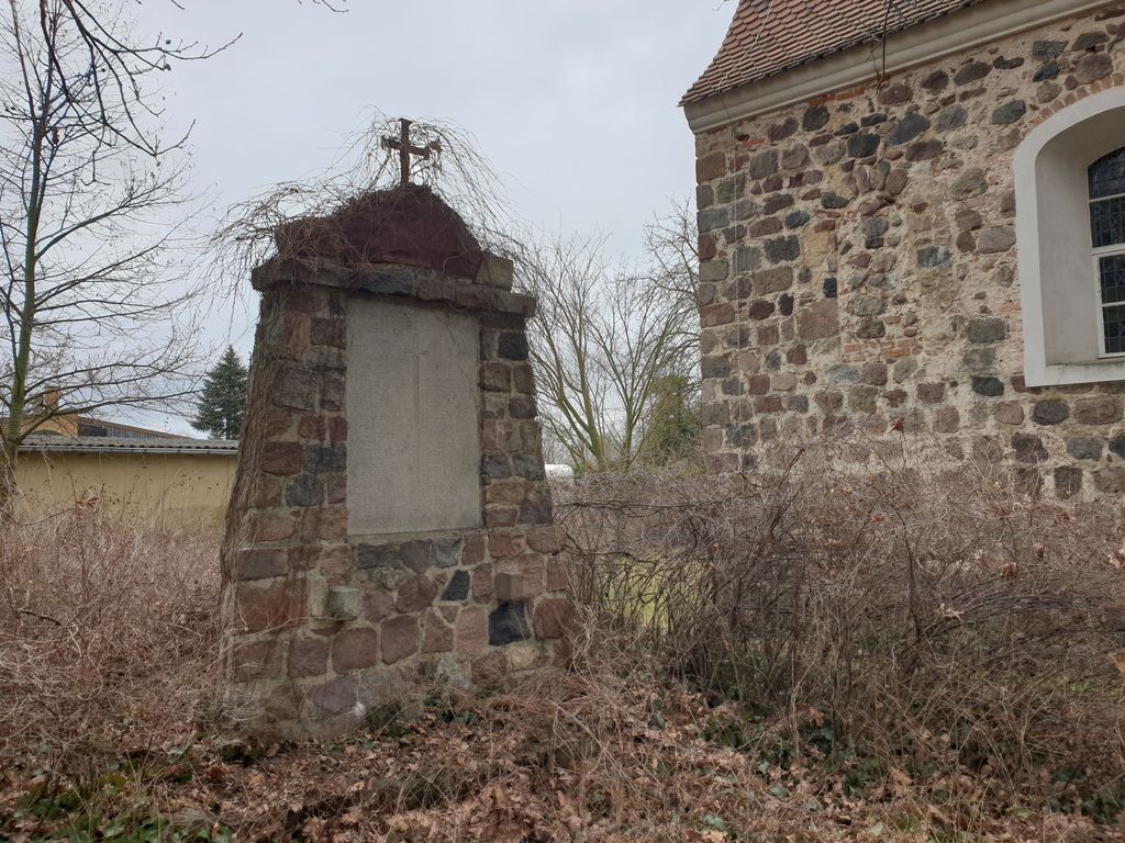
| Description | : | The parish of Ruhlsdorf is one of the smallest parishes in the Brandenburg part of the Teltow-Zehlendorf parish. It is located in the Ruhlsdorf district of the city of Teltow and belongs to the Potsdam-Mittelmark district. It can look back on over 700 years of history. The churchyard is located around the village church, which dates back to the 13th century. Funerals no longer take place in the village cemetery. A few meters from the church there is a memorial to those who fell in the First World War. It was built by the warrior fellowship. |
frequently asked questions (FAQ):
-
Where is Dorfkirchhof Ruhlsdorf, Teltow?
Dorfkirchhof Ruhlsdorf, Teltow is located at Dorfstraße 3 Teltow, Landkreis Potsdam-Mittelmark ,Brandenburg , 14513Germany.
-
Dorfkirchhof Ruhlsdorf, Teltow cemetery's updated grave count on graveviews.com?
0 memorials
-
Where are the coordinates of the Dorfkirchhof Ruhlsdorf, Teltow?
Latitude: 52.3746670
Longitude: 13.2679067

Nearby Cemetories:
1. Ehemaliger Gutsfriedhof Ruhlsdorf
Teltow, Landkreis Potsdam-Mittelmark, Germany
Coordinate: 52.3691003, 13.2709522
2. Friedhof Ruhlsdorf, Teltow
Teltow, Landkreis Potsdam-Mittelmark, Germany
Coordinate: 52.3706082, 13.2552694
3. Friedhof Teltow
Teltow, Landkreis Potsdam-Mittelmark, Germany
Coordinate: 52.4008256, 13.2568985
4. Gedenkstätte für die Opfer des Faschismus
Grossbeeren, Landkreis Teltow-Fläming, Germany
Coordinate: 52.3564975, 13.3034204
5. Friedhof Großbeeren
Grossbeeren, Landkreis Teltow-Fläming, Germany
Coordinate: 52.3558200, 13.3026170
6. Alter Friedhof Großbeeren
Grossbeeren, Landkreis Teltow-Fläming, Germany
Coordinate: 52.3559118, 13.3075660
7. Friedhof Stahnsdorf
Stahnsdorf, Landkreis Potsdam-Mittelmark, Germany
Coordinate: 52.3868750, 13.2196840
8. Dorfkirchhof Kleinmachnow
Kleinmachnow, Landkreis Potsdam-Mittelmark, Germany
Coordinate: 52.3950092, 13.2239098
9. Friedhof Schönow - Zehlendorf
Zehlendorf, Steglitz-Zehlendorf, Germany
Coordinate: 52.4097149, 13.2666497
10. Dorfkirche Stahnsdorf
Stahnsdorf, Landkreis Potsdam-Mittelmark, Germany
Coordinate: 52.3920802, 13.2163727
11. Friedhof Kleinbeeren
Kleinbeeren, Landkreis Teltow-Fläming, Germany
Coordinate: 52.3611770, 13.3248638
12. Friedhof Heinersdorf
Heinersdorf, Landkreis Teltow-Fläming, Germany
Coordinate: 52.3873801, 13.3275049
13. Friedhof Güterfelde
Güterfelde, Landkreis Potsdam-Mittelmark, Germany
Coordinate: 52.3588780, 13.1945250
14. Parkfriedhof Lichterfelde
Lichterfelde, Steglitz-Zehlendorf, Germany
Coordinate: 52.4213890, 13.2908330
15. Privatfriedhof der Familie Dr. Heinrich Laehr
Zehlendorf, Steglitz-Zehlendorf, Germany
Coordinate: 52.4270392, 13.2644428
16. Dorfkirchhof Lichterfelde-Giesensdorf
Lichterfelde, Steglitz-Zehlendorf, Germany
Coordinate: 52.4210590, 13.3115809
17. Südwestkirchhof Stahnsdorf
Stahnsdorf, Landkreis Potsdam-Mittelmark, Germany
Coordinate: 52.3888893, 13.1805563
18. Südwestfriedhof Berliner Synode Italian Military
Stahnsdorf, Landkreis Potsdam-Mittelmark, Germany
Coordinate: 52.3828000, 13.1766600
19. Wilmersdorfer Waldfriedhof Stahnsdorf
Landkreis Potsdam-Mittelmark, Germany
Coordinate: 52.3942100, 13.1808010
20. Südwestfriedhof der Berliner Synode Military
Stahnsdorf, Landkreis Potsdam-Mittelmark, Germany
Coordinate: 52.3833313, 13.1752081
21. Wilmersdorfer Waldfriedhof Güterfelde
Landkreis Potsdam-Mittelmark, Germany
Coordinate: 52.3808990, 13.1733360
22. Waldfriedhof Zehlendorf
Nikolassee, Steglitz-Zehlendorf, Germany
Coordinate: 52.4241670, 13.2111110
23. Dorffriedhof Zehlendorf
Zehlendorf, Steglitz-Zehlendorf, Germany
Coordinate: 52.4357600, 13.2595500
24. Friedhof Lankwitz
Lankwitz, Steglitz-Zehlendorf, Germany
Coordinate: 52.4239950, 13.3342570