
| Memorials | : | 0 |
| Location | : | Stahnsdorf, Landkreis Potsdam-Mittelmark, Germany |
| Coordinate | : | 52.3828000, 13.1766600 |
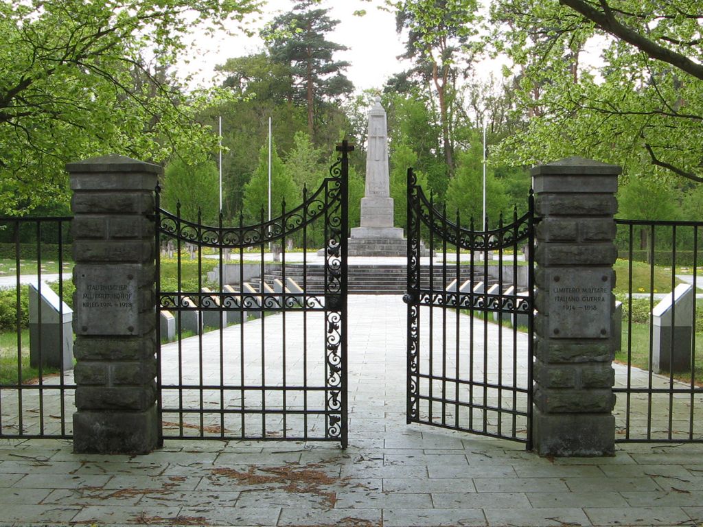
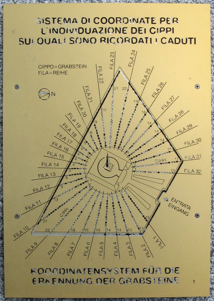
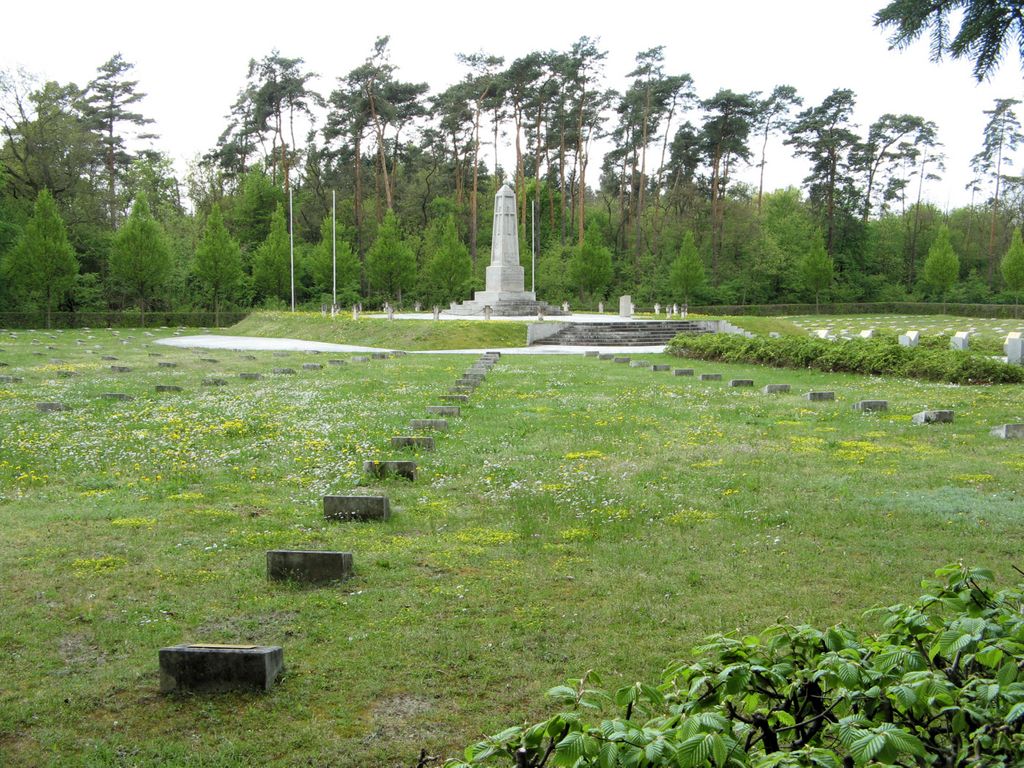
| Description | : | This Italian Military Cemetery is a self-contained cemetery within the Südwestfriedhof der Berliner Synode at its southwestern end. It contains the graves of 1,658 Italian solders who lost their lives during the First World War (1914-1918). Most of these persons were prisoners of war in the Berlin and Brandenburg area who died from the strains and hardships of captivity. The design of the cemetery follows a circular and radial scheme, the center of which is an obelisk within a square (representing the earthly world) and 32 radial rows of graves in concentric circles (representing the heavenly sphere, based on a concept... Read More |
frequently asked questions (FAQ):
-
Where is Südwestfriedhof Berliner Synode Italian Military?
Südwestfriedhof Berliner Synode Italian Military is located at Bahnhofstrasse 2 Stahnsdorf, Landkreis Potsdam-Mittelmark ,Brandenburg , 14532Germany.
-
Südwestfriedhof Berliner Synode Italian Military cemetery's updated grave count on graveviews.com?
0 memorials
-
Where are the coordinates of the Südwestfriedhof Berliner Synode Italian Military?
Latitude: 52.3828000
Longitude: 13.1766600
Nearby Cemetories:
1. Südwestfriedhof der Berliner Synode Military
Stahnsdorf, Landkreis Potsdam-Mittelmark, Germany
Coordinate: 52.3833313, 13.1752081
2. Wilmersdorfer Waldfriedhof Güterfelde
Landkreis Potsdam-Mittelmark, Germany
Coordinate: 52.3808990, 13.1733360
3. Südwestkirchhof Stahnsdorf
Stahnsdorf, Landkreis Potsdam-Mittelmark, Germany
Coordinate: 52.3888893, 13.1805563
4. Wilmersdorfer Waldfriedhof Stahnsdorf
Landkreis Potsdam-Mittelmark, Germany
Coordinate: 52.3942100, 13.1808010
5. Dorfkirche Stahnsdorf
Stahnsdorf, Landkreis Potsdam-Mittelmark, Germany
Coordinate: 52.3920802, 13.2163727
6. Friedhof Güterfelde
Güterfelde, Landkreis Potsdam-Mittelmark, Germany
Coordinate: 52.3588780, 13.1945250
7. Friedhof Stahnsdorf
Stahnsdorf, Landkreis Potsdam-Mittelmark, Germany
Coordinate: 52.3868750, 13.2196840
8. Dorfkirchhof Kleinmachnow
Kleinmachnow, Landkreis Potsdam-Mittelmark, Germany
Coordinate: 52.3950092, 13.2239098
9. Friedhof Drewitz
Drewitz, Stadtkreis Potsdam, Germany
Coordinate: 52.3569540, 13.1322360
10. Friedhof Wannsee I - Friedenstrasse
Wannsee, Steglitz-Zehlendorf, Germany
Coordinate: 52.4142265, 13.1408291
11. Friedhof Wannsee II - Lindenstrasse
Wannsee, Steglitz-Zehlendorf, Germany
Coordinate: 52.4252243, 13.1538744
12. Friedhof Goethestraße
Potsdam, Stadtkreis Potsdam, Germany
Coordinate: 52.3969700, 13.1054900
13. Waldfriedhof Zehlendorf
Nikolassee, Steglitz-Zehlendorf, Germany
Coordinate: 52.4241670, 13.2111110
14. Friedhof Nikolassee
Nikolassee, Steglitz-Zehlendorf, Germany
Coordinate: 52.4262900, 13.2045100
15. Friedhof Großbeerenstraße in Potsdam-Babelsberg
Babelsberg, Stadtkreis Potsdam, Germany
Coordinate: 52.3856519, 13.1002058
16. Evang. Friedhof am Plantagenplatz
Babelsberg, Stadtkreis Potsdam, Germany
Coordinate: 52.3934945, 13.1011823
17. Friedhof Ruhlsdorf, Teltow
Teltow, Landkreis Potsdam-Mittelmark, Germany
Coordinate: 52.3706082, 13.2552694
18. Friedhof Teltow
Teltow, Landkreis Potsdam-Mittelmark, Germany
Coordinate: 52.4008256, 13.2568985
19. Friedhof der Pfaueninsel am Nikolskoe
Wannsee, Steglitz-Zehlendorf, Germany
Coordinate: 52.4232064, 13.1186031
20. St. Peter und Paul auf Nikolskoe
Wannsee, Steglitz-Zehlendorf, Germany
Coordinate: 52.4244440, 13.1191670
21. Friedhof Klein Glienicke
Klein Glienicke, Stadtkreis Potsdam, Germany
Coordinate: 52.4131750, 13.0997759
22. Dorfkirchhof Ruhlsdorf, Teltow
Teltow, Landkreis Potsdam-Mittelmark, Germany
Coordinate: 52.3746670, 13.2679067
23. Prinzenfriedhof Klein-Glienicke
Wannsee, Steglitz-Zehlendorf, Germany
Coordinate: 52.4171810, 13.1001030
24. Ehemaliger Gutsfriedhof Ruhlsdorf
Teltow, Landkreis Potsdam-Mittelmark, Germany
Coordinate: 52.3691003, 13.2709522