
| Memorials | : | 0 |
| Location | : | Haskins, Wood County, USA |
| Coordinate | : | 41.4836600, -83.7310500 |
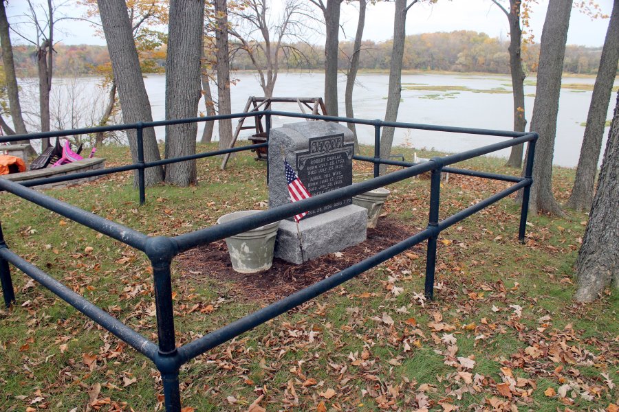
| Description | : | According to the genealogy "The Dunlaps" by Jeane Wilson (who's husband James is a direct descendant: "The Dunlap Monument is located on the north side of State Rte. #65, which is on the south side of the Maumee River; it is west of Forst Road on private property, the estate of Mrs. Henry Dodge; 1998 address: 17090 West River Road, Bowling Green, Ohio 43402. Her phone number is 419-878-3606. The plot is listed as River Tract #45 of Middleton Twp. Wood Co. Ohio. Mrs. Dodge, is a sprite 85 year old lady, who cares for the graveside and... Read More |
frequently asked questions (FAQ):
-
Where is Dunlap Cemetery?
Dunlap Cemetery is located at 17090 W. River Road Haskins, Wood County ,Ohio , 43402USA.
-
Dunlap Cemetery cemetery's updated grave count on graveviews.com?
0 memorials
-
Where are the coordinates of the Dunlap Cemetery?
Latitude: 41.4836600
Longitude: -83.7310500
Nearby Cemetories:
1. Highland Memory Gardens
Waterville, Lucas County, USA
Coordinate: 41.4881100, -83.7410500
2. Miltonville Cemetery
Haskins, Wood County, USA
Coordinate: 41.4853400, -83.7162500
3. Wakeman Cemetery
Waterville, Lucas County, USA
Coordinate: 41.4978300, -83.7263300
4. Lyon Cemetery
Perrysburg, Wood County, USA
Coordinate: 41.5205200, -83.7035500
5. Whitehouse Cemetery
Whitehouse, Lucas County, USA
Coordinate: 41.5197983, -83.7845001
6. Tontogany Cemetery
Tontogany, Wood County, USA
Coordinate: 41.4294014, -83.7427979
7. Mennonite Cemetery
Whitehouse, Lucas County, USA
Coordinate: 41.5235176, -83.7817841
8. Otsego Cemetery
Tontogany, Wood County, USA
Coordinate: 41.4444008, -83.7827988
9. Saint Mary Mother of Sorrows Cemetery
Roachton, Wood County, USA
Coordinate: 41.5075970, -83.6607170
10. Allen-Lloyd Cemetery
Monclova Township, Lucas County, USA
Coordinate: 41.5415130, -83.7492190
11. Karnik Memorial Garden Pet Cemetery
Waterville, Lucas County, USA
Coordinate: 41.5435980, -83.7174500
12. Rupp Cemetery
Whitehouse, Lucas County, USA
Coordinate: 41.5323067, -83.7855759
13. Washington Cemetery
Tontogany, Wood County, USA
Coordinate: 41.4227982, -83.7675018
14. Heffelbower Cemetery
Lucas County, USA
Coordinate: 41.5534248, -83.7308426
15. Winslow Cemetery
Whitehouse, Lucas County, USA
Coordinate: 41.5345000, -83.8007700
16. Roth Cemetery
Monclova, Lucas County, USA
Coordinate: 41.5549270, -83.7526420
17. Riverside Cemetery
Maumee, Lucas County, USA
Coordinate: 41.5491982, -83.6810989
18. Fallen Timbers Battlefield Memorial Park
Monclova Township, Lucas County, USA
Coordinate: 41.5541972, -83.6899056
19. Union Hill Cemetery
Bowling Green, Wood County, USA
Coordinate: 41.4239006, -83.6632996
20. Saint Joseph Cemetery
Maumee, Lucas County, USA
Coordinate: 41.5578003, -83.6706009
21. Fort Meigs State Memorial
Perrysburg, Wood County, USA
Coordinate: 41.5496380, -83.6517710
22. Swan Creek Cemetery
Monclova, Lucas County, USA
Coordinate: 41.5738983, -83.7089005
23. Fort Meigs Cemetery
Perrysburg, Wood County, USA
Coordinate: 41.5517006, -83.6402969
24. Plain Township Cemetery
Bowling Green, Wood County, USA
Coordinate: 41.3861600, -83.7104900