
| Memorials | : | 1 |
| Location | : | Egersund, Eigersund kommune, Norway |
| Coordinate | : | 58.4459600, 6.0041540 |
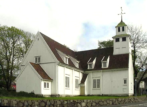
| Description | : | Egersund (or Ekersund) Ladesteds Churchyard is on the south-west coast of Norway. From Egersund follow the 44 in the direction Hauge I Dalane. The church is about 1 kilometre from Egersund on the right of the 44. The churchyard is located on the right of the church. Egersund (or Ekersund) Churchyard contains seven Commonwealth burials of the Second World War, one of them unidentified. There are also five First World War burials in the churchyard, one of them unidentified by name, all Naval casualties from the Battle of Jutland in 1916. |
frequently asked questions (FAQ):
-
Where is Egersund Churchyard?
Egersund Churchyard is located at Egersund, Eigersund kommune ,Rogaland fylke ,Norway.
-
Egersund Churchyard cemetery's updated grave count on graveviews.com?
1 memorials
-
Where are the coordinates of the Egersund Churchyard?
Latitude: 58.4459600
Longitude: 6.0041540
Nearby Cemetories:
1. Helleland Churchyard
Helleland, Sola kommune, Norway
Coordinate: 58.5209130, 6.1155580
2. Ogna Cemetery
Ogna, Hå kommune, Norway
Coordinate: 58.5169010, 5.8085240
3. Bjerkreim Church Cemetery
Bjerkreim, Bjerkreim kommune, Norway
Coordinate: 58.5836000, 6.0769000
4. Frøyland gravplass
Sokndal kommune, Norway
Coordinate: 58.3433400, 6.3073650
5. Eikedal Cemetery
Hauge i Dalane, Sokndal kommune, Norway
Coordinate: 58.3450000, 6.3108700
6. Varhaug Kirke
Varhaug, Hå kommune, Norway
Coordinate: 58.5984640, 5.6620260
7. Ivesdal Cemetery
Bjerkreim kommune, Norway
Coordinate: 58.6881710, 6.1593670
8. Varhaug Old Cemetery
Hå kommune, Norway
Coordinate: 58.6103180, 5.6175370
9. Ana Sira Church Cemetery
Ana-Sira, Sokndal kommune, Norway
Coordinate: 58.2934000, 6.4421000
10. Lund kirkegård - Moi
Moi, Lund kommune, Norway
Coordinate: 58.4477540, 6.5535102
11. Time Cemetery
Time, Time kommune, Norway
Coordinate: 58.7264850, 5.6965630
12. Kvanvik Cemetery
Kvanvik, Flekkefjord kommune, Norway
Coordinate: 58.2850100, 6.5385200
13. Gjesdal Cemetery
Kydland, Gjesdal kommune, Norway
Coordinate: 58.7733300, 5.9474000
14. Aalgaard Cemetery
Algard, Gjesdal kommune, Norway
Coordinate: 58.7690140, 5.8456070
15. Bakke Cemetery
Sira, Flekkefjord kommune, Norway
Coordinate: 58.4142000, 6.6590000
16. Hidra Churchyard
Rasvag, Flekkefjord kommune, Norway
Coordinate: 58.2329770, 6.5373100
17. Orre Cemetery
Orre, Klepp kommune, Norway
Coordinate: 58.7154680, 5.5640600
18. Tjørsvaag Cemetery
Flekkefjord, Flekkefjord kommune, Norway
Coordinate: 58.2971090, 6.6463100
19. Klepp Sor
Klepp, Klepp kommune, Norway
Coordinate: 58.7724900, 5.6239820
20. Klepp Church Cemetery
Klepp, Klepp kommune, Norway
Coordinate: 58.7731620, 5.6249890
21. Sundslia Churchyard
Flekkefjord, Flekkefjord kommune, Norway
Coordinate: 58.2968210, 6.6811160
22. Dirdal
Dirdal, Gjesdal kommune, Norway
Coordinate: 58.8273600, 6.1902300
23. Høyland Cemetery
Sandnes, Sandnes kommune, Norway
Coordinate: 58.8308000, 5.7498000
24. Bore Church Cemetery
Klepp, Klepp kommune, Norway
Coordinate: 58.7947860, 5.5989930