
| Memorials | : | 0 |
| Location | : | Moi, Lund kommune, Norway |
| Coordinate | : | 58.4477540, 6.5535102 |
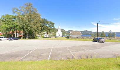
| Description | : | Lund cemetery at Moi is located around Lund church, but essentially south of the church, down towards Lundevannet (lake). Short path both north and west of the church are remains of burial grounds, so probably the first church, from approx. 1618, raised in connection with this. Demolition of the old church and construction of the present took place in 1808 - 12. It is built in wood and has 330 seats. Lund church was inaugurated on September 13, 1812, the church is in Lund's parish in Dalane prosti. Various restoration work has been carried out over the years.... Read More |
frequently asked questions (FAQ):
-
Where is Lund kirkegård - Moi?
Lund kirkegård - Moi is located at Skålandsveien 122 Moi, Lund kommune ,Rogaland fylke , 4460Norway.
-
Lund kirkegård - Moi cemetery's updated grave count on graveviews.com?
0 memorials
-
Where are the coordinates of the Lund kirkegård - Moi?
Latitude: 58.4477540
Longitude: 6.5535102
Nearby Cemetories:
1. Bakke Cemetery
Sira, Flekkefjord kommune, Norway
Coordinate: 58.4142000, 6.6590000
2. Tjørsvaag Cemetery
Flekkefjord, Flekkefjord kommune, Norway
Coordinate: 58.2971090, 6.6463100
3. Kvanvik Cemetery
Kvanvik, Flekkefjord kommune, Norway
Coordinate: 58.2850100, 6.5385200
4. Eikedal Cemetery
Hauge i Dalane, Sokndal kommune, Norway
Coordinate: 58.3450000, 6.3108700
5. Ana Sira Church Cemetery
Ana-Sira, Sokndal kommune, Norway
Coordinate: 58.2934000, 6.4421000
6. Sundslia Churchyard
Flekkefjord, Flekkefjord kommune, Norway
Coordinate: 58.2968210, 6.6811160
7. Frøyland gravplass
Sokndal kommune, Norway
Coordinate: 58.3433400, 6.3073650
8. Hidra Churchyard
Rasvag, Flekkefjord kommune, Norway
Coordinate: 58.2329770, 6.5373100
9. Feda Churchyard
Feda, Kvinesdal kommune, Norway
Coordinate: 58.2629160, 6.8198570
10. Skeihaugen
Sirdal kommune, Norway
Coordinate: 58.6679360, 6.7213640
11. Helleland Churchyard
Helleland, Sola kommune, Norway
Coordinate: 58.5209130, 6.1155580
12. Fjotland
Kvinesdal, Kvinesdal kommune, Norway
Coordinate: 58.5249440, 6.9911710
13. Kvinesdal
Kvinesdal, Kvinesdal kommune, Norway
Coordinate: 58.3170980, 6.9605850
14. Bjerkreim Church Cemetery
Bjerkreim, Bjerkreim kommune, Norway
Coordinate: 58.5836000, 6.0769000
15. Egersund Churchyard
Egersund, Eigersund kommune, Norway
Coordinate: 58.4459600, 6.0041540
16. Ivesdal Cemetery
Bjerkreim kommune, Norway
Coordinate: 58.6881710, 6.1593670
17. Herad Kyrkje
Herad, Farsund kommune, Norway
Coordinate: 58.1561398, 6.7957986
18. Eiken Churchyard
Eiken, Hægebostad kommune, Norway
Coordinate: 58.4779030, 7.2084190
19. Vanse Kyrkje
Farsund, Farsund kommune, Norway
Coordinate: 58.1005708, 6.6940280
20. Hægebostad Kirke
Hægebostad kommune, Norway
Coordinate: 58.3403323, 7.2061549
21. Farsund kirke
Farsund, Farsund kommune, Norway
Coordinate: 58.0947530, 6.7984450
22. Frelserens Kirke
Farsund, Farsund kommune, Norway
Coordinate: 58.0941415, 6.7975047
23. Lunde
Sirdal kommune, Norway
Coordinate: 58.8084080, 6.7634580
24. Kvaas Cemetery
Lyngdal kommune, Norway
Coordinate: 58.2632950, 7.1993080