
| Memorials | : | 0 |
| Location | : | Coventry, Kent County, USA |
| Coordinate | : | 41.6821747, -71.5767746 |
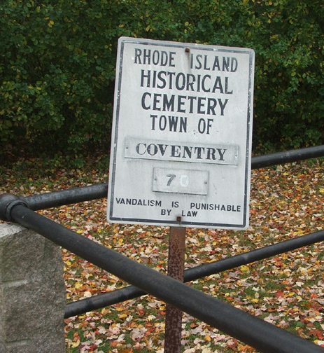
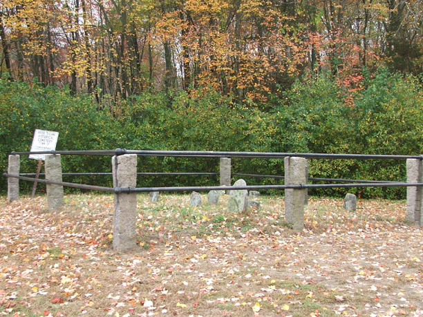
| Description | : | This lot is located behind St. John and Paul Church on Tiogue Avenue (Rt. 3). Go to the rear of the parking lot; right in front of the school. The lot is enclosed and has a historic cemetery sign. The only stone which can be read is a marker erected to Elkanah Johnson. The front of this marker is damaged, with only parts of the inscription remaining. The remaining stones are fieldstones. Originally, there were 3 other stones which had inscriptions, all of which were members of the Johnson family. |
frequently asked questions (FAQ):
-
Where is Elkanah Johnson Lot?
Elkanah Johnson Lot is located at Coventry, Kent County ,Rhode Island ,USA.
-
Elkanah Johnson Lot cemetery's updated grave count on graveviews.com?
0 memorials
-
Where are the coordinates of the Elkanah Johnson Lot?
Latitude: 41.6821747
Longitude: -71.5767746
Nearby Cemetories:
1. Aaron Bowen Lot
Coventry, Kent County, USA
Coordinate: 41.6820946, -71.5679016
2. Bissell-Whipple-Stone Lot
Coventry, Kent County, USA
Coordinate: 41.6889496, -71.5699539
3. Cromwell Whipple Monument
Coventry, Kent County, USA
Coordinate: 41.6884500, -71.5672700
4. Ambrose Rogers Lot
Coventry, Kent County, USA
Coordinate: 41.6842100, -71.5642600
5. Brayton Burial Ground
Coventry, Kent County, USA
Coordinate: 41.6910290, -71.5694780
6. Irwin-Hines Lot
Coventry, Kent County, USA
Coordinate: 41.6876100, -71.5648600
7. Battey Family Cemetery
Coventry, Kent County, USA
Coordinate: 41.6676500, -71.5717200
8. Goff Lot
Coventry, Kent County, USA
Coordinate: 41.6672790, -71.5720430
9. Abbott-Colvin Lot
Coventry, Kent County, USA
Coordinate: 41.6984100, -71.5769300
10. Deacon John Wood Cemetery
Coventry, Kent County, USA
Coordinate: 41.6742325, -71.5968246
11. Arnold - Hopkins Lot (Defunct)
West Warwick, Kent County, USA
Coordinate: 41.6943200, -71.5601000
12. Barber Lot
Coventry, Kent County, USA
Coordinate: 41.6860600, -71.6026970
13. Jabez Anthony Lot
Coventry, Kent County, USA
Coordinate: 41.6700280, -71.5545830
14. Hangmans Hill Lot
West Greenwich, Kent County, USA
Coordinate: 41.6603060, -71.5753060
15. Briggs Lot
Coventry, Kent County, USA
Coordinate: 41.7048500, -71.5842900
16. Gorton Lot
Coventry, Kent County, USA
Coordinate: 41.6686897, -71.6060257
17. Friends Burial Ground
Coventry, Kent County, USA
Coordinate: 41.6991196, -71.5495071
18. Amherst Hopkins Cemetery
Coventry, Kent County, USA
Coordinate: 41.6778100, -71.5406300
19. Greene Homestead Burial Ground
Coventry, Kent County, USA
Coordinate: 41.6942900, -71.5421100
20. Arnold-Stone Lot
Coventry, Kent County, USA
Coordinate: 41.7045900, -71.5509600
21. Thomas Matteson Lot
West Warwick, Kent County, USA
Coordinate: 41.6924910, -71.5387710
22. Arnold Lot
Coventry, Kent County, USA
Coordinate: 41.7042999, -71.6044006
23. Arnold Cemetery
Coventry, Kent County, USA
Coordinate: 41.7089100, -71.5573100
24. Anthony Lot
Coventry, Kent County, USA
Coordinate: 41.6629700, -71.5440800