| Memorials | : | 2 |
| Location | : | Hartford, Washington County, USA |
| Coordinate | : | 43.2768900, -88.3410100 |
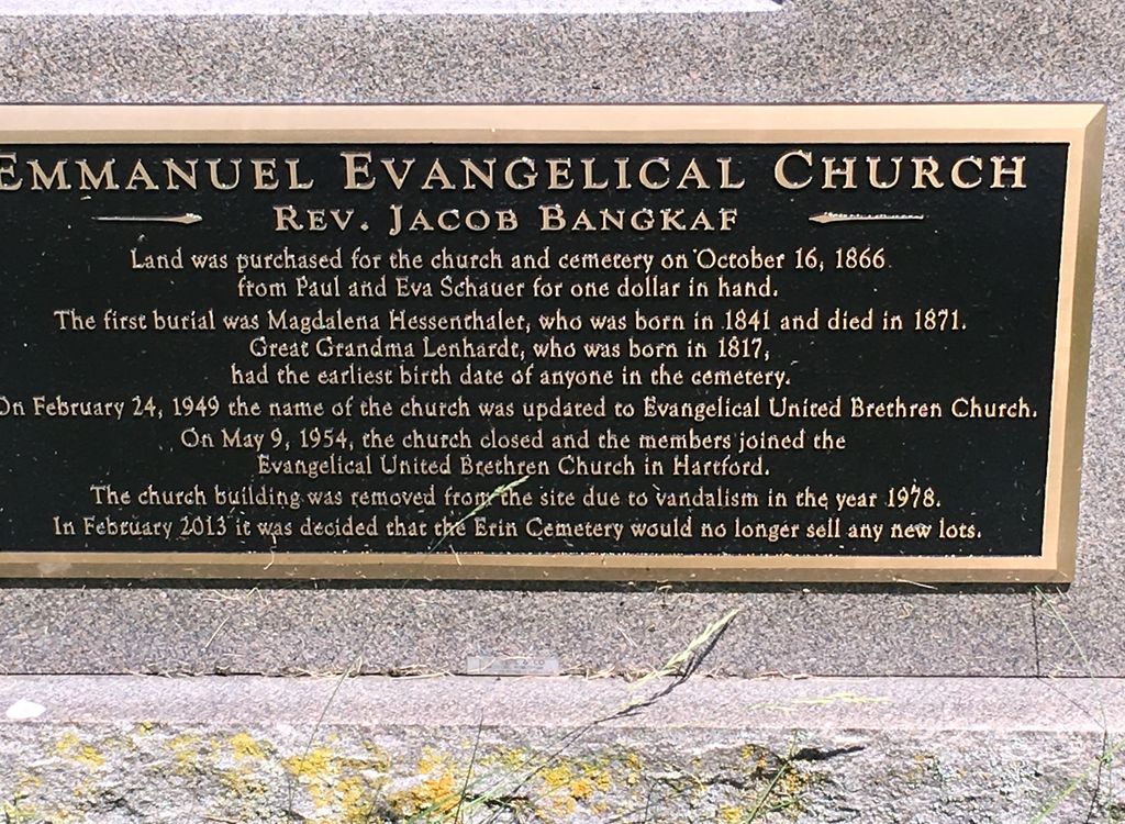
| Description | : | This is a small cemetery enclosed in a fence in which the original church was removed. Hwy K located one mile north of the intersection of Hwy K and Loghouse Road in the Town of Erin. The name of this cemetery is Emmanuel Evangelical United Brethren Cemetery. This congregation never used the word Lutheran in its name. This information comes from the local historian at the Hartford History Room. Emmanuel Evangelical United Brethren closed in 1954. |
frequently asked questions (FAQ):
-
Where is Erin Emmanuel Lutheran Cemetery?
Erin Emmanuel Lutheran Cemetery is located at Hwy K Hartford, Washington County ,Wisconsin , 53027USA.
-
Erin Emmanuel Lutheran Cemetery cemetery's updated grave count on graveviews.com?
2 memorials
-
Where are the coordinates of the Erin Emmanuel Lutheran Cemetery?
Latitude: 43.2768900
Longitude: -88.3410100
Nearby Cemetories:
1. Saint Patrick's Catholic Cemetery New
Erin, Washington County, USA
Coordinate: 43.2591660, -88.3666250
2. Saint Patrick Catholic Cemetery Old
Thompson, Washington County, USA
Coordinate: 43.2597500, -88.3709700
3. Carmelite Cemetery
Hubertus, Washington County, USA
Coordinate: 43.2483030, -88.3299550
4. Saint Mary of the Hill Parish Cemetery
Hubertus, Washington County, USA
Coordinate: 43.2518260, -88.3009280
5. Faith Cemetery
Slinger, Washington County, USA
Coordinate: 43.2950400, -88.2807900
6. Saint Kilian Cemetery Old
Hartford, Washington County, USA
Coordinate: 43.3210600, -88.3651500
7. Union Cemetery
Hartford, Washington County, USA
Coordinate: 43.3147011, -88.3831024
8. First Presbyterian Church Cemetery
Richfield, Washington County, USA
Coordinate: 43.2729130, -88.2618910
9. Pleasant Hill Cemetery
Hartford, Washington County, USA
Coordinate: 43.3196983, -88.3996964
10. Saint John United Church of Christ Cemetery
Slinger, Washington County, USA
Coordinate: 43.3299190, -88.2878160
11. Saint Kilian Cemetery New
Hartford, Washington County, USA
Coordinate: 43.3306000, -88.3942000
12. Saint Johns Catholic Cemetery
Washington County, USA
Coordinate: 43.2081000, -88.3410000
13. Saint Paul Lutheran Cemetery
Slinger, Washington County, USA
Coordinate: 43.3279720, -88.2758120
14. Saint Peter Cemetery Old
Slinger, Washington County, USA
Coordinate: 43.3335100, -88.2821600
15. Faith United Church of Christ Akerville Cemetery
Ackerville, Washington County, USA
Coordinate: 43.3031679, -88.2501243
16. Rosenheimer Cemetery
Slinger, Washington County, USA
Coordinate: 43.3365900, -88.2875600
17. Saint Peter Cemetery New
Slinger, Washington County, USA
Coordinate: 43.3437500, -88.3042200
18. Saint Marys Church Cemetery
Richfield, Washington County, USA
Coordinate: 43.2775497, -88.2407684
19. Saylesville Cemetery
Rubicon, Dodge County, USA
Coordinate: 43.2986031, -88.4385681
20. Rettler Farm Cemetery
Hartford, Washington County, USA
Coordinate: 43.3501690, -88.3595430
21. Saint Pauls United Church of Christ Cemetery
Plat, Washington County, USA
Coordinate: 43.2071900, -88.3010900
22. Union Cemetery
Slinger, Washington County, USA
Coordinate: 43.3396988, -88.2822037
23. Toland Norwegian Methodist Cemetery
Erin, Washington County, USA
Coordinate: 43.2239409, -88.4181211
24. Saint Olafs Cemetery
Alderley, Dodge County, USA
Coordinate: 43.2253418, -88.4273682


