
| Memorials | : | 7 |
| Location | : | Mount Laurel, Burlington County, USA |
| Coordinate | : | 39.9351130, -74.8915510 |
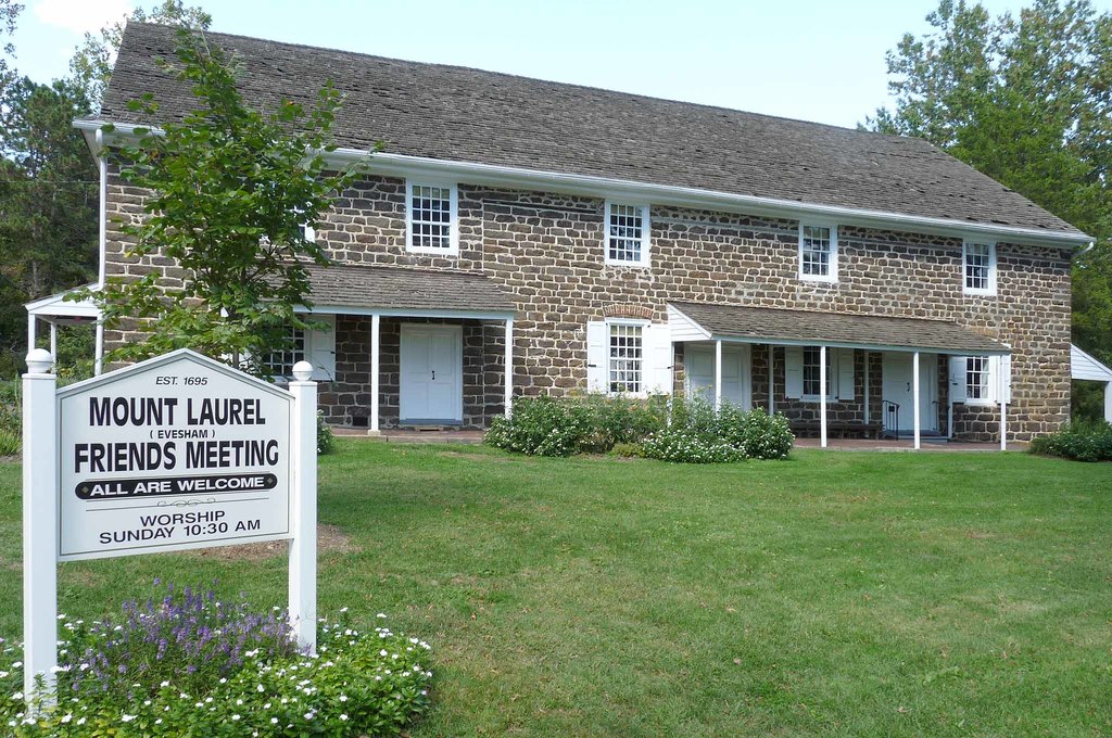
| Description | : | Evesham Friends Cemetery no longer exist. In 1695, Quakers in New Jersey living between Haddonfield and Mount Holly formed an association called Evesham Meeting and in 1698 built a meeting house at present Mount Laurel. In 1717, a graveyard was established next to the meeting house on land donated by William Evans. Evesham Friends meeting records were kept by Haddonfield Monthly Meeting until 1759, at which time Evesham Meeting became Evesham Monthly Meeting. In 1760, a brick meeting house was built and is still in use today as the Mount Laurel Meeting House. This stone building was built in front of... Read More |
frequently asked questions (FAQ):
-
Where is Evesham Friends Cemetery?
Evesham Friends Cemetery is located at 438 Mount Laurel Rd Mount Laurel, Burlington County ,New Jersey , 08054USA.
-
Evesham Friends Cemetery cemetery's updated grave count on graveviews.com?
4 memorials
-
Where are the coordinates of the Evesham Friends Cemetery?
Latitude: 39.9351130
Longitude: -74.8915510
Nearby Cemetories:
1. Jacob's Chapel Cemetery
Mount Laurel, Burlington County, USA
Coordinate: 39.9297670, -74.8852350
2. Mount Laurel Friends Burying Ground
Mount Laurel, Burlington County, USA
Coordinate: 39.9286000, -74.8853920
3. Eldridge Cemetery
Mount Laurel, Burlington County, USA
Coordinate: 39.9268837, -74.8968887
4. Mount Laurel Cemetery
Mount Laurel, Burlington County, USA
Coordinate: 39.9272003, -74.8977966
5. Darnell Family Cemetery
Mount Laurel, Burlington County, USA
Coordinate: 39.9535520, -74.8728800
6. Easton Union Cemetery
Hainesport, Burlington County, USA
Coordinate: 39.9658012, -74.8503036
7. Jesus Bread of Life Catholic Cemetery
Mount Laurel, Burlington County, USA
Coordinate: 39.9773600, -74.8673100
8. Prince of Peace Lutheran Church Memorial Garden
Marlton, Burlington County, USA
Coordinate: 39.8928080, -74.9201920
9. Old Marlton Baptist Cemetery
Marlton, Burlington County, USA
Coordinate: 39.8899300, -74.9183400
10. Marlton United Methodist Cemetery
Marlton, Burlington County, USA
Coordinate: 39.8899918, -74.9195023
11. Moorestown Friends Cemetery
Moorestown, Burlington County, USA
Coordinate: 39.9661522, -74.9430237
12. First Baptist Church Cemetery
Moorestown, Burlington County, USA
Coordinate: 39.9644737, -74.9483109
13. Saint Matthew Lutheran Church Garden of Remembranc
Moorestown, Burlington County, USA
Coordinate: 39.9684660, -74.9444600
14. Trinity Episcopal Churchyard
Moorestown, Burlington County, USA
Coordinate: 39.9634056, -74.9507599
15. Cropwell Friends Meeting House Cemetery
Cropwell, Burlington County, USA
Coordinate: 39.8931732, -74.9364319
16. First United Methodist Church Memorial Garden
Moorestown, Burlington County, USA
Coordinate: 39.9583720, -74.9623130
17. Marlton Cemetery
Marlton, Burlington County, USA
Coordinate: 39.8767320, -74.9039320
18. Saint Bartholomews Episcopal Church Memorial Garde
Cherry Hill, Camden County, USA
Coordinate: 39.8980760, -74.9558630
19. Medford Friends Meeting Cemetery
Medford, Burlington County, USA
Coordinate: 39.8992081, -74.8255463
20. First Presbyterian Church Cemetery
Moorestown, Burlington County, USA
Coordinate: 39.9795700, -74.9501600
21. Medford Methodist Cemetery
Medford, Burlington County, USA
Coordinate: 39.9008408, -74.8200302
22. Medford Friends Hicksite Burial Ground
Medford, Burlington County, USA
Coordinate: 39.8978940, -74.8219260
23. Haines Family Farm Cemetery
Medford, Burlington County, USA
Coordinate: 39.9235020, -74.8079980
24. Park View Cemetery
Medford, Burlington County, USA
Coordinate: 39.8983955, -74.8207779