
| Memorials | : | 0 |
| Location | : | Melrose, Paulding County, USA |
| Coordinate | : | 41.1116420, -84.4146810 |
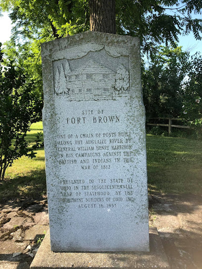
| Description | : | Site of a war of 1812 Fort that was built built at the confluence of the Big and Little Auglaize Rivers. Reportably three graves were buried here but no longer exist (See brown biograghy); site was of 1835 Village of "Fort Brown" (Unincorporated community} The cemetery is located in Brown Township, Paulding County, Ohio, and is # 9228 (Fort Brown Cemetery) in “Ohio Cemeteries 1803-2003”, compiled by the Ohio Genealogical Society. |
frequently asked questions (FAQ):
-
Where is Fort Brown Cemetery?
Fort Brown Cemetery is located at County Road 171 Melrose, Paulding County ,Ohio , 45873USA.
-
Fort Brown Cemetery cemetery's updated grave count on graveviews.com?
0 memorials
-
Where are the coordinates of the Fort Brown Cemetery?
Latitude: 41.1116420
Longitude: -84.4146810
Nearby Cemetories:
1. Kingery Cemetery
Paulding County, USA
Coordinate: 41.1138992, -84.4107971
2. Switzer Cemetery
Melrose, Paulding County, USA
Coordinate: 41.1030312, -84.4227982
3. Blakeslee Cemetery
Charloe, Paulding County, USA
Coordinate: 41.1288986, -84.4330978
4. Sherman Cemetery
Paulding, Paulding County, USA
Coordinate: 41.1347008, -84.4266968
5. Hoover Cemetery
Brown Township, Paulding County, USA
Coordinate: 41.1358720, -84.4011130
6. Oakwood Cemetery
Oakwood, Paulding County, USA
Coordinate: 41.0998370, -84.3807000
7. Little Auglaize Cemetery
Melrose, Paulding County, USA
Coordinate: 41.0780572, -84.4196320
8. Prairie Chapel Cemetery
Oakwood, Paulding County, USA
Coordinate: 41.0999985, -84.3625031
9. Bowholtz Cemetery
Oakwood, Paulding County, USA
Coordinate: 41.1074982, -84.4705963
10. Harrell Cemetery
Paulding County, USA
Coordinate: 41.0572970, -84.3939360
11. Landis-Harvey Cemetery
Junction, Paulding County, USA
Coordinate: 41.1655830, -84.4430690
12. Wilson Cemetery
Paulding County, USA
Coordinate: 41.0518990, -84.4052963
13. Auglaize Chapel Church of God Cemetery
Paulding County, USA
Coordinate: 41.0480995, -84.3882980
14. Mount Zion Cemetery
Latty, Paulding County, USA
Coordinate: 41.0536003, -84.4582977
15. Myers-Hosterman Cemetery
Junction, Paulding County, USA
Coordinate: 41.1763690, -84.4402500
16. Dotterer Cemetery
Auglaize Township, Paulding County, USA
Coordinate: 41.1727982, -84.4614029
17. Oak Grove Cemetery
Paulding County, USA
Coordinate: 41.0629997, -84.3460007
18. Mellinger Cemetery
Paulding County, USA
Coordinate: 41.0363998, -84.3918991
19. Middle Creek Zion Baptist Church Cemetery
Roselms, Paulding County, USA
Coordinate: 41.0340004, -84.4179993
20. Hedges Cemetery
Paulding, Paulding County, USA
Coordinate: 41.0924988, -84.5194016
21. Saint Marys Catholic Church Cemetery
Junction, Paulding County, USA
Coordinate: 41.1870003, -84.4599991
22. Boutwell Cemetery
Paulding County, USA
Coordinate: 41.0327988, -84.3807983
23. Junction Cemetery
Paulding County, USA
Coordinate: 41.1878014, -84.4589005
24. Carlton Cemetery
Paulding County, USA
Coordinate: 41.0303001, -84.3827972