
| Memorials | : | 2 |
| Location | : | Grayson County, USA |
| Coordinate | : | 36.6098900, -81.2954560 |
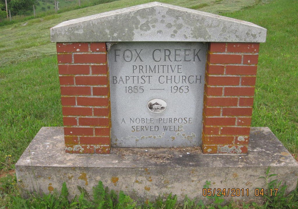
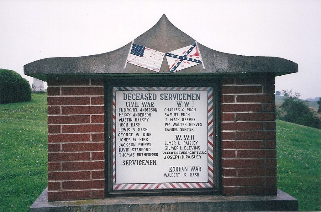
| Description | : | This cemetery is on Fox Creek Road (Rt 711) due north of the intersection with Wilson Hwy (US 58), About 9 miles west of Independence, Virginia. |
frequently asked questions (FAQ):
-
Where is Fox Creek Primitive Baptist Church?
Fox Creek Primitive Baptist Church is located at Fox Creek Road Grayson County ,Virginia ,USA.
-
Fox Creek Primitive Baptist Church cemetery's updated grave count on graveviews.com?
2 memorials
-
Where are the coordinates of the Fox Creek Primitive Baptist Church?
Latitude: 36.6098900
Longitude: -81.2954560


Nearby Cemetories:
1. Fox Union Cemetery
Independence, Grayson County, USA
Coordinate: 36.6096992, -81.2957993
2. Billy Bryant Cemetery
Fox, Grayson County, USA
Coordinate: 36.6160590, -81.2940820
3. Thomas Hash Family Cemetery
Fox, Grayson County, USA
Coordinate: 36.6137480, -81.3033860
4. Jesse Cox Cemetery
Fox, Grayson County, USA
Coordinate: 36.6061920, -81.2821810
5. Allen Hash Family Cemetery
Fox, Grayson County, USA
Coordinate: 36.6136000, -81.3092500
6. Anderson Rutherford Family Cemetery
Fox, Grayson County, USA
Coordinate: 36.5971924, -81.2858573
7. William C. Halsey Cemetery
Mouth of Wilson, Grayson County, USA
Coordinate: 36.5970730, -81.3052600
8. Ezekiel Young Cemetery
Fox, Grayson County, USA
Coordinate: 36.6231450, -81.3110960
9. Jacob G Kirk Cemetery
Bridle Creek, Grayson County, USA
Coordinate: 36.6043810, -81.2725240
10. Arthur Brewer Family Cemetery
Fox, Grayson County, USA
Coordinate: 36.6284910, -81.3064030
11. George W Delp Cemetery
Mouth of Wilson, Grayson County, USA
Coordinate: 36.5879040, -81.2934230
12. Hash-Osborne Cemetery
Mouth of Wilson, Grayson County, USA
Coordinate: 36.6188220, -81.3215860
13. R T Brewer Family Cemetery
Fox, Grayson County, USA
Coordinate: 36.6319500, -81.3089290
14. Reed Cox Cemetery
Bridle Creek, Grayson County, USA
Coordinate: 36.6174390, -81.2661810
15. Gold Hill Cemetery
Independence, Grayson County, USA
Coordinate: 36.6074630, -81.2640310
16. James P. Hash Cemetery
Independence, Grayson County, USA
Coordinate: 36.6074630, -81.2640310
17. B H Phipps Family Cemetery
Bridle Creek, Grayson County, USA
Coordinate: 36.6287000, -81.2722000
18. J Masten Halsey Cemetery
Mouth of Wilson, Grayson County, USA
Coordinate: 36.5823930, -81.3024720
19. Grayson County Poor Farm Cemetery
Independence, Grayson County, USA
Coordinate: 36.6240130, -81.2650110
20. Wilborn Ross Cemetery
Mouth of Wilson, Grayson County, USA
Coordinate: 36.5870800, -81.3177700
21. Gold Hill Cemetery - Old
Independence, Grayson County, USA
Coordinate: 36.6035900, -81.2601310
22. Potato Creek Cemetery
Mouth of Wilson, Grayson County, USA
Coordinate: 36.5835991, -81.2794037
23. William Halsey Cemetery
Mouth of Wilson, Grayson County, USA
Coordinate: 36.5938470, -81.3265710
24. Joseph Hash Family Cemetery
Fox, Grayson County, USA
Coordinate: 36.6264040, -81.3271960