
| Memorials | : | 0 |
| Location | : | Toddville, Dorchester County, USA |
| Coordinate | : | 38.3119990, -76.0953300 |
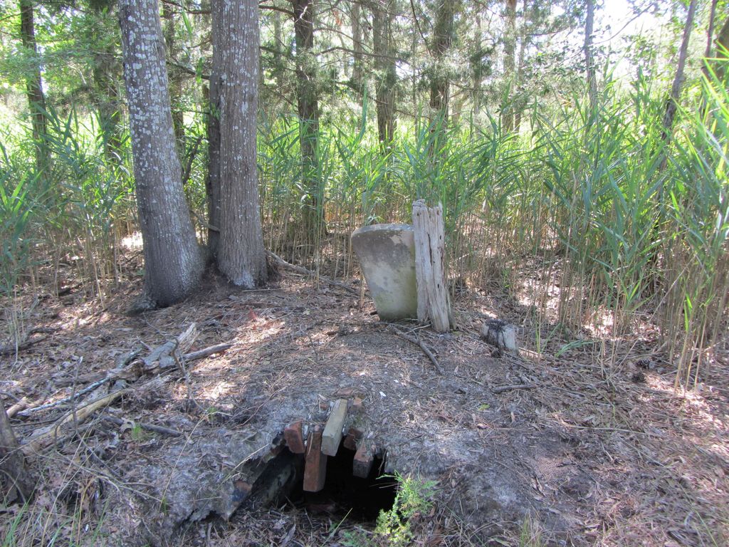
| Description | : | Described as the Frank Hayward Home, Toddville, Straits District in the Tombstone Book of Dorchester County. The property is on Wesley Church Road, approximately .10 miles north of its intersection with Toddville Rd. The grave site is in the woods approximately 600 feet west of the road. |
frequently asked questions (FAQ):
-
Where is Frank Hayward Home Cemetery?
Frank Hayward Home Cemetery is located at Toddville, Dorchester County ,Maryland ,USA.
-
Frank Hayward Home Cemetery cemetery's updated grave count on graveviews.com?
0 memorials
-
Where are the coordinates of the Frank Hayward Home Cemetery?
Latitude: 38.3119990
Longitude: -76.0953300
Nearby Cemetories:
1. Zebedee Hayward Home Cemetery
Wingate, Dorchester County, USA
Coordinate: 38.3188000, -76.0882600
2. Zebidee Hayward Home Cemetery
Toddville, Dorchester County, USA
Coordinate: 38.3188700, -76.0882200
3. Charles Wingate Home Cemetery
Wingate, Dorchester County, USA
Coordinate: 38.3058520, -76.1047080
4. William Andrews Family Cemetery
Crapo, Dorchester County, USA
Coordinate: 38.3188400, -76.1105500
5. Ebenezer Cemetery
Dorchester County, USA
Coordinate: 38.3168983, -76.1153030
6. Zion Cemetery
Williamsburg, Dorchester County, USA
Coordinate: 38.2966995, -76.0691986
7. Isaac Andrews Home Cemetery
Toddville, Dorchester County, USA
Coordinate: 38.3205800, -76.0584400
8. Roberts Home Cemetery
Andrews, Dorchester County, USA
Coordinate: 38.3552120, -76.1024980
9. Wyville Andrews Farm Cemetery
Lakesville, Dorchester County, USA
Coordinate: 38.3548210, -76.1241990
10. George Carroll Insley Farm Cemetery
Lakesville, Dorchester County, USA
Coordinate: 38.3414270, -76.1497050
11. Bramble Family Cemetery
Dorchester County, USA
Coordinate: 38.2691200, -76.0479600
12. Robinson Family Cemetery
Dorchester County, USA
Coordinate: 38.2672200, -76.0466300
13. Martinek Family Cemetery
Elliott, Dorchester County, USA
Coordinate: 38.3067800, -76.0106800
14. Sandy Island Cemetery
Robbins, Dorchester County, USA
Coordinate: 38.3827900, -76.0629100
15. Elliotts Cemetery
Dorchester County, USA
Coordinate: 38.2924995, -76.0025024
16. John Wesley United Methodist Church Cemetery
Church Creek, Dorchester County, USA
Coordinate: 38.3823200, -76.1472800
17. Bethany Cemetery
Dorchester County, USA
Coordinate: 38.2355995, -76.0597000
18. Middle Hooper Island Cemetery
Fishing Creek, Dorchester County, USA
Coordinate: 38.2680180, -76.1832290
19. Gootee Cemetery
Dorchester County, USA
Coordinate: 38.3793983, -76.1718979
20. Saint Johns United Methodist Church Cemetery
Church Creek, Dorchester County, USA
Coordinate: 38.3821983, -76.1936035
21. Old Hoopers Island Graveyard
Dorchester County, USA
Coordinate: 38.3468159, -76.2297535
22. Insley Cemetery
Dorchester County, USA
Coordinate: 38.4310989, -76.0689011
23. Blackwater National Wildlife Refuge Cemetery
Church Creek, Dorchester County, USA
Coordinate: 38.4239450, -76.1752370
24. Saint Peters Methodist Episcopal Church Cemetery
Church Creek, Dorchester County, USA
Coordinate: 38.3798570, -76.2504790