
| Memorials | : | 0 |
| Location | : | Dagebull, Kreis Nordfriesland, Germany |
| Coordinate | : | 54.7304200, 8.7235300 |
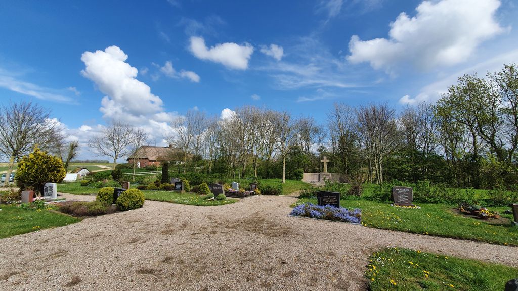
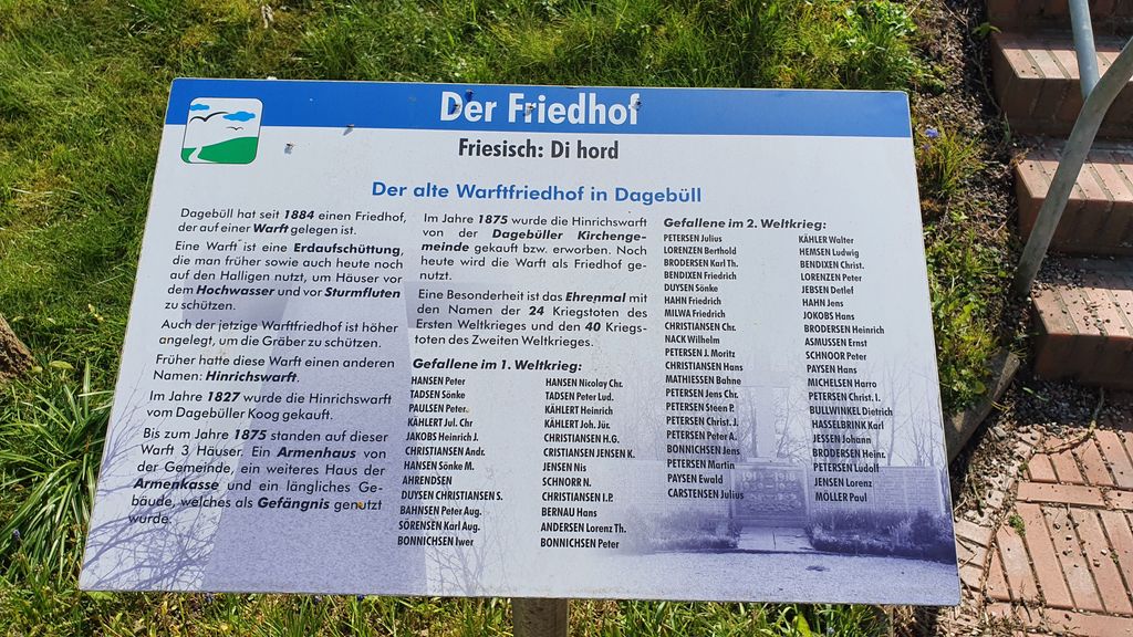
| Description | : | Dagebüll is a municipality located at the west coast of Schleswig-Holstein in the Nordfriesland district, Germany. It's on the mainland just across the water from the island of Föhr. Today's Dagebüll was created in 1978 as a merger of the municipalities of Dagebüll, Fahretoft, Juliane-Marien-Koog and Waygaard. Dagebüll has less than 1000 inhabitants. The small cemetery is located east of the village of Dagebüll. It's managed by the Lutheran congregation of Dagebüll. There is a War Memorial Plot with the names of the fallen soldiers and killed civilians of World Wars I and II in the middle of the cemetery.... Read More |
frequently asked questions (FAQ):
-
Where is Friedhof Dagebüll?
Friedhof Dagebüll is located at Dorfstrasse Dagebull, Kreis Nordfriesland ,Schleswig-Holstein , 25899Germany.
-
Friedhof Dagebüll cemetery's updated grave count on graveviews.com?
0 memorials
-
Where are the coordinates of the Friedhof Dagebüll?
Latitude: 54.7304200
Longitude: 8.7235300
Nearby Cemetories:
1. Friedhof Deezbüll
Deezbüll, Kreis Nordfriesland, Germany
Coordinate: 54.7776616, 8.8147038
2. Parkfriedhof Niebüll
Niebüll, Kreis Nordfriesland, Germany
Coordinate: 54.7904535, 8.8387020
3. Friedhof Wyk auf Föhr
Boldixum, Kreis Nordfriesland, Germany
Coordinate: 54.6954900, 8.5510100
4. Friedhof Stedesand
Stedesand, Kreis Nordfriesland, Germany
Coordinate: 54.7384122, 8.9305541
5. Friedhof Neukirchen
Rodenas, Kreis Nordfriesland, Germany
Coordinate: 54.8660878, 8.7355666
6. Friedhof Nieblum auf Föhr
Nieblum, Kreis Nordfriesland, Germany
Coordinate: 54.6934060, 8.4911330
7. Friedhof Braderup
Braderup, Kreis Nordfriesland, Germany
Coordinate: 54.8342848, 8.8909250
8. Enger Friedhof
Enge, Kreis Nordfriesland, Germany
Coordinate: 54.7283600, 8.9797400
9. Leck Friedhof
Leck, Kreis Nordfriesland, Germany
Coordinate: 54.7747776, 8.9798520
10. Friedhof Humptrup
Humptrup, Kreis Nordfriesland, Germany
Coordinate: 54.8630646, 8.8652848
11. St. Nikolai zu Bordelum
Bordelum, Kreis Nordfriesland, Germany
Coordinate: 54.6383240, 8.9411910
12. Friedhof Rodenäs
Rodenas, Kreis Nordfriesland, Germany
Coordinate: 54.8887661, 8.6998137
13. Friedhof Süderende auf Föhr
Suderende, Kreis Nordfriesland, Germany
Coordinate: 54.7162700, 8.4352300
14. Friedhof Aventoft
Aventoft, Kreis Nordfriesland, Germany
Coordinate: 54.9003772, 8.8153899
15. Friedhof Bredstedt
Bredstedt, Kreis Nordfriesland, Germany
Coordinate: 54.6153270, 8.9655360
16. Ubjerg kirkegård
Ubjerg, Tønder Kommune, Denmark
Coordinate: 54.9123677, 8.8548693
17. St.-Petri Kirche Friedhof
Ladelund, Kreis Nordfriesland, Germany
Coordinate: 54.8409180, 9.0245260
18. Møgeltønder Kirkegård
Mogeltonder, Tønder Kommune, Denmark
Coordinate: 54.9406590, 8.8031660
19. Friedhof Morsum
Morsum, Kreis Nordfriesland, Germany
Coordinate: 54.8677177, 8.4332085
20. Alter Friedhof Nebel
Nebel, Kreis Nordfriesland, Germany
Coordinate: 54.6529950, 8.3554090
21. Daler Cemetery
Tønder Kommune, Denmark
Coordinate: 54.9696400, 8.7461500
22. Friedhof Nordhackstedt
Nordhackstedt, Kreis Schleswig-Flensburg, Germany
Coordinate: 54.7338210, 9.1691548
23. St. Marien Kirche Friedhof
Hattstedt, Kreis Nordfriesland, Germany
Coordinate: 54.5251480, 9.0205530
24. Friedhof Sankt Severin
Keitum, Kreis Nordfriesland, Germany
Coordinate: 54.9026700, 8.3636300