
| Memorials | : | 0 |
| Location | : | Holtgast, Landkreis Wittmund, Germany |
| Coordinate | : | 53.6325400, 7.5257600 |
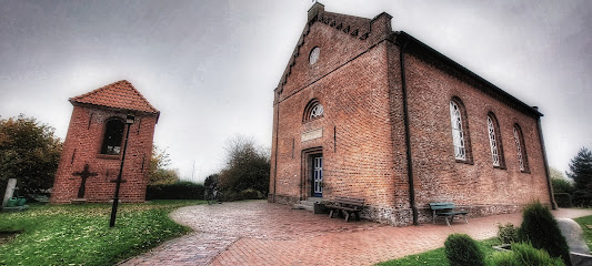
| Description | : | This is a small Lutheran Cemetery in the village of Fulkum. It's owned and managed by the Lutheran Maria-Magdalenen-Congregation. It is only half an acre in size and surrounds the small Lutheran church. Please note that the graves in Germany are not perpetual. After a certain period of repose (20-30 years) the graves are being leveled and re-used. There is no toxic embalming being done in Germany, so the coffin and the corpse have decomposed naturally. If the family of the deceased decides to purchase another period the duration can be extended by another 30 years. War Graves are considered memorials... Read More |
frequently asked questions (FAQ):
-
Where is Friedhof Fulkum?
Friedhof Fulkum is located at Kirchstrasse Holtgast, Landkreis Wittmund ,Lower Saxony (Niedersachsen) , 26427Germany.
-
Friedhof Fulkum cemetery's updated grave count on graveviews.com?
0 memorials
-
Where are the coordinates of the Friedhof Fulkum?
Latitude: 53.6325400
Longitude: 7.5257600
Nearby Cemetories:
1. Friedhof Roggenstede
Dornum, Landkreis Aurich, Germany
Coordinate: 53.6308960, 7.4852930
2. Alter Friedhof Ochtersum
Westochtersum, Landkreis Wittmund, Germany
Coordinate: 53.6090937, 7.5081946
3. Neuer Friedhof Ochtersum
Westochtersum, Landkreis Wittmund, Germany
Coordinate: 53.6085986, 7.5028889
4. Friedhof Westerbur
Dornum, Landkreis Aurich, Germany
Coordinate: 53.6576870, 7.4947990
5. Friedhof Westeraccum
Dornum, Landkreis Aurich, Germany
Coordinate: 53.6497340, 7.4429280
6. Jüdischer Friedhof Esens
Esens, Landkreis Wittmund, Germany
Coordinate: 53.6369722, 7.6140194
7. Friedhof Resterhafe
Dornum, Landkreis Aurich, Germany
Coordinate: 53.6377450, 7.4342680
8. Friedhof Esens
Esens, Landkreis Wittmund, Germany
Coordinate: 53.6466182, 7.6179006
9. Friedhof Westerholt
Westerholt, Landkreis Wittmund, Germany
Coordinate: 53.5912025, 7.4584699
10. Friedhof Blomberg Ostfriesland
Blomberg, Landkreis Wittmund, Germany
Coordinate: 53.5750020, 7.5458370
11. Friedhof Dornum
Dornum, Landkreis Aurich, Germany
Coordinate: 53.6460280, 7.4281890
12. Jüdischer Friedhof Dornum
Dornum, Landkreis Aurich, Germany
Coordinate: 53.6476400, 7.4263930
13. Neuer Friedhof Donum
Esens, Landkreis Wittmund, Germany
Coordinate: 53.5955300, 7.6444200
14. Alter Friedhof Dunum
Esens, Landkreis Wittmund, Germany
Coordinate: 53.5958390, 7.6459330
15. Friedhof Stedesdorf
Esens, Landkreis Wittmund, Germany
Coordinate: 53.6258740, 7.6626590
16. Alter Friedhof Arle
Arle, Landkreis Aurich, Germany
Coordinate: 53.6095000, 7.3911300
17. Arle Friedhof
Arle, Landkreis Aurich, Germany
Coordinate: 53.6084500, 7.3860700
18. Friedhof Nesse
Dornum, Landkreis Aurich, Germany
Coordinate: 53.6542637, 7.3805201
19. Friedhof Grossheide
Grossheide, Landkreis Aurich, Germany
Coordinate: 53.5860270, 7.3576030
20. Friedhof Middels
Aurich, Landkreis Aurich, Germany
Coordinate: 53.5372000, 7.6217200
21. Friedhof Burhafe
Burhafe, Landkreis Wittmund, Germany
Coordinate: 53.5991650, 7.7072890
22. Friedhof Werdum
Esens, Landkreis Wittmund, Germany
Coordinate: 53.6593161, 7.7148162
23. Friedhof Langeoog-Kirche
Langeoog, Landkreis Wittmund, Germany
Coordinate: 53.7459350, 7.4818160
24. Russenfriedhof Tannenhausen
Aurich, Landkreis Aurich, Germany
Coordinate: 53.5200437, 7.4741757