
| Memorials | : | 0 |
| Location | : | Dornum, Landkreis Aurich, Germany |
| Coordinate | : | 53.6476400, 7.4263930 |
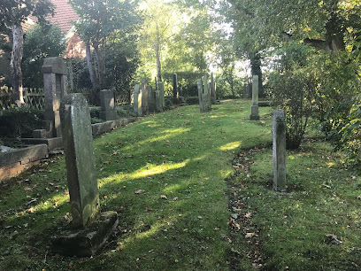
| Description | : | This Jewish cemetery was opened in 1723. For over 200 years the Jewish families of Dornum buried their dead here. After the Nazis took over and following the Night of the Cristals (Reichskristallnacht) in 1938 the cemetery was vandalized and the entire history of the cemetery, including the interment records were burned. About 150 grave stones were stolen and used as pavers or in building construction. 36 grave stones were rescued by civilians and after the war returned to the authorities. The cemetery was cleaned up, but at this point the original location for the surviving stones could not be established.... Read More |
frequently asked questions (FAQ):
-
Where is Jüdischer Friedhof Dornum?
Jüdischer Friedhof Dornum is located at Markstrasse Dornum, Landkreis Aurich ,Lower Saxony (Niedersachsen) , 26553Germany.
-
Jüdischer Friedhof Dornum cemetery's updated grave count on graveviews.com?
0 memorials
-
Where are the coordinates of the Jüdischer Friedhof Dornum?
Latitude: 53.6476400
Longitude: 7.4263930
Nearby Cemetories:
1. Friedhof Dornum
Dornum, Landkreis Aurich, Germany
Coordinate: 53.6460280, 7.4281890
2. Friedhof Westeraccum
Dornum, Landkreis Aurich, Germany
Coordinate: 53.6497340, 7.4429280
3. Friedhof Resterhafe
Dornum, Landkreis Aurich, Germany
Coordinate: 53.6377450, 7.4342680
4. Friedhof Nesse
Dornum, Landkreis Aurich, Germany
Coordinate: 53.6542637, 7.3805201
5. Friedhof Roggenstede
Dornum, Landkreis Aurich, Germany
Coordinate: 53.6308960, 7.4852930
6. Friedhof Westerbur
Dornum, Landkreis Aurich, Germany
Coordinate: 53.6576870, 7.4947990
7. Alter Friedhof Arle
Arle, Landkreis Aurich, Germany
Coordinate: 53.6095000, 7.3911300
8. Arle Friedhof
Arle, Landkreis Aurich, Germany
Coordinate: 53.6084500, 7.3860700
9. Friedhof Westerholt
Westerholt, Landkreis Wittmund, Germany
Coordinate: 53.5912025, 7.4584699
10. Neuer Friedhof Ochtersum
Westochtersum, Landkreis Wittmund, Germany
Coordinate: 53.6085986, 7.5028889
11. Friedhof Fulkum
Holtgast, Landkreis Wittmund, Germany
Coordinate: 53.6325400, 7.5257600
12. Alter Friedhof Ochtersum
Westochtersum, Landkreis Wittmund, Germany
Coordinate: 53.6090937, 7.5081946
13. Friedhof Grossheide
Grossheide, Landkreis Aurich, Germany
Coordinate: 53.5860270, 7.3576030
14. Friedhof Baltrum
Baltrum, Landkreis Aurich, Germany
Coordinate: 53.7257200, 7.3857600
15. Alter Friedhof Hage
Hage, Landkreis Aurich, Germany
Coordinate: 53.6020600, 7.2840430
16. Friedhof Berumerfehn
Grossheide, Landkreis Aurich, Germany
Coordinate: 53.5621750, 7.3461360
17. Friedhof Hage
Hage, Landkreis Aurich, Germany
Coordinate: 53.6033960, 7.2741190
18. Friedhof Blomberg Ostfriesland
Blomberg, Landkreis Wittmund, Germany
Coordinate: 53.5750020, 7.5458370
19. Friedhof Langeoog-Kirche
Langeoog, Landkreis Wittmund, Germany
Coordinate: 53.7459350, 7.4818160
20. Jüdischer Friedhof Esens
Esens, Landkreis Wittmund, Germany
Coordinate: 53.6369722, 7.6140194
21. Dünenfriedhof Langeoog
Langeoog, Landkreis Wittmund, Germany
Coordinate: 53.7533330, 7.4894440
22. Friedhof Esens
Esens, Landkreis Wittmund, Germany
Coordinate: 53.6466182, 7.6179006
23. Russenfriedhof Tannenhausen
Aurich, Landkreis Aurich, Germany
Coordinate: 53.5200437, 7.4741757
24. Friedhof Rechtsupweg
Rechtsupweg, Landkreis Aurich, Germany
Coordinate: 53.5298350, 7.3275200