
| Memorials | : | 0 |
| Location | : | Albertaich, Landkreis Traunstein, Germany |
| Website | : | www.obing.de/?Sehenswertes___Kirche_Albertaich |
| Coordinate | : | 48.0169803, 12.3664307 |
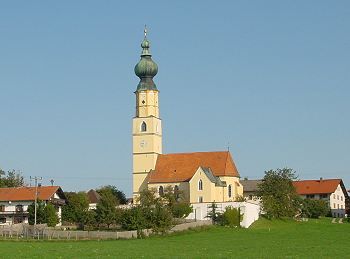
| Description | : | Auf einem Moränenrücken liegt der Ort Albertaich. Der Turm der kleinen Filialkirche ist schon von weitem sichtbar. Der Graubündner Gaspare Zucalli hat den spätgotischen Bau 1670 umgestaltet. Die Kirche war einst eine vielbesuchte Wallfahrt. Sehenswert ist das kostbare Altarbild der Kirche: Es stellt den Hl. Jakobus dar, dem Maria auf einer Säule erscheint nach dem Vorbild der "Virgen del Pilar" in Saragossa. Die Ausstattung ist außerordentlich reich, qualitätvoll und einheitlich. Die drei Altäre entstanden um 1672 und haben eine Schwarz-Gold-Fassung. Sie bieten ein Höchstmaß an Qualität und Reife, was die Schnitzereien angeht. Die Figuren halten die Balance zwischen Ernst und Frohsinn und... Read More |
frequently asked questions (FAQ):
-
Where is Friedhof St. Jakobus d. Ä. Albertaich?
Friedhof St. Jakobus d. Ä. Albertaich is located at Albertaich Albertaich, Landkreis Traunstein ,Bavaria (Bayern) , 83119Germany.
-
Friedhof St. Jakobus d. Ä. Albertaich cemetery's updated grave count on graveviews.com?
0 memorials
-
Where are the coordinates of the Friedhof St. Jakobus d. Ä. Albertaich?
Latitude: 48.0169803
Longitude: 12.3664307
Nearby Cemetories:
1. Gemeindefriedhof Obing
Obing, Landkreis Traunstein, Germany
Coordinate: 48.0056124, 12.4067529
2. Kirchenfriedhof St. Laurentius, Obing
Obing, Landkreis Traunstein, Germany
Coordinate: 48.0011952, 12.4079182
3. Seeon Abbey
Seeon-Seebruck, Landkreis Traunstein, Germany
Coordinate: 47.9751830, 12.4483930
4. Stadtfriedhof Wasserburg
Wasserburg am Inn, Landkreis Rosenheim, Germany
Coordinate: 48.0625800, 12.2297800
5. Friedhof Am Herder Wasserburg am Inn
Wasserburg am Inn, Landkreis Rosenheim, Germany
Coordinate: 48.0451622, 12.2118379
6. Waldfriedhof Altenmarkt
Altenmarkt an der Alz, Landkreis Traunstein, Germany
Coordinate: 47.9991731, 12.5271219
7. Friedhof Trostberg
Trostberg an der Alz, Landkreis Traunstein, Germany
Coordinate: 48.0314459, 12.5579546
8. Friedhof Breitbrunn
Breitbrunn am Chiemsee, Landkreis Rosenheim, Germany
Coordinate: 47.8888515, 12.4006793
9. Antwort
Antwort, Landkreis Rosenheim, Germany
Coordinate: 47.8914389, 12.3047614
10. Friedhof St. Georgen
Sankt Georgen, Landkreis Traunstein, Germany
Coordinate: 47.9714402, 12.5638597
11. Katholischer Friedhof Edling
Edling, Landkreis Rosenheim, Germany
Coordinate: 48.0581600, 12.1620400
12. Friedhof Ramerberg
Ramerberg, Landkreis Rosenheim, Germany
Coordinate: 48.0179966, 12.1453783
13. Fraueninsel Cemetery
Chiemsee, Landkreis Rosenheim, Germany
Coordinate: 47.8724890, 12.4248170
14. Inselfriedhof Frauenchiemsee
Stadtkreis Rosenheim, Germany
Coordinate: 47.8724820, 12.4263610
15. Klosterkirche Mariä Himmelfahrt
Gars, Landkreis Mühldorf am Inn, Germany
Coordinate: 48.1559580, 12.2760530
16. Friedhof Prien am Chiemsee
Prien am Chiemsee, Landkreis Rosenheim, Germany
Coordinate: 47.8586140, 12.3440160
17. Friedhof Rott am Inn
Rott am Inn, Landkreis Rosenheim, Germany
Coordinate: 47.9826501, 12.1297863
18. Waldfriedhof Traunreut
Traunreut, Landkreis Traunstein, Germany
Coordinate: 47.9651947, 12.6017370
19. Friedhof Traunwalchen
Traunwalchen, Landkreis Traunstein, Germany
Coordinate: 47.9417477, 12.6029173
20. Friedhof
Rechtmehring, Landkreis Mühldorf am Inn, Germany
Coordinate: 48.1274560, 12.1575826
21. Mariä Himmelfahrt
Aschau am Inn, Landkreis Mühldorf am Inn, Germany
Coordinate: 48.1978180, 12.3449380
22. Kloster Ramsau
Ramsau, Landkreis Mühldorf am Inn, Germany
Coordinate: 48.1735950, 12.2284910
23. Katholische Kapelle von Oberhochstätt
Oberhochstatt, Landkreis Traunstein, Germany
Coordinate: 47.8732100, 12.5408200
24. Friedhof Haag
Haag in Oberbayern, Landkreis Mühldorf am Inn, Germany
Coordinate: 48.1592500, 12.1805700