
| Memorials | : | 12 |
| Location | : | Manchester, Metropolitan Borough of Manchester, England |
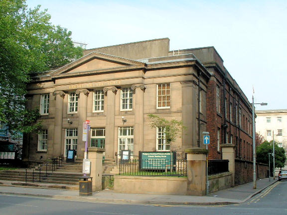
| Description | : | The burial ground was used by the Manchester Society of Friends from 1796 to 1856. It was situated beside the Mount Street meeting house. The 1849 Ordnance Survey map shows that it extends along the side of the building with a substantial wall surrounding it to deter grave robbers. The remains of some 600 Friends rest here. It has been covered over and now serves as a parking lot. The burial registers are on microfilm at the Manchester Central Library. |
frequently asked questions (FAQ):
-
Where is Friends Burial Ground (Defunct)?
Friends Burial Ground (Defunct) is located at No GPS information available Add GPSMount Street Manchester, Metropolitan Borough of Manchester ,Greater Manchester ,England.
-
Friends Burial Ground (Defunct) cemetery's updated grave count on graveviews.com?
12 memorials
Nearby Cemetories:
1. Chorlton Green Cemetery
Chorlton-Cum-Hardy, Metropolitan Borough of Manchester, England
Coordinate: 53.5062710, -2.2179570
2. Southern Cemetery
Chorlton-Cum-Hardy, Metropolitan Borough of Manchester, England
3. St Clement Churchyard
Chorlton-Cum-Hardy, Metropolitan Borough of Manchester, England
4. Christchurch Harpurhey Churchyard
Harpurhey, Metropolitan Borough of Manchester, England
5. Cross Street Chapel
Manchester, Metropolitan Borough of Manchester, England
6. Crumpsall Jewish Cemetery
Manchester, Metropolitan Borough of Manchester, England
Coordinate: 53.4817542, -2.2457527
7. Friends Graveyard Deansgate
Manchester, Metropolitan Borough of Manchester, England
8. Gorton Cemetery
Manchester, Metropolitan Borough of Manchester, England
Coordinate: 53.4777660, -2.2453600
9. Great Bridgewater St. Wesleyan Methodist Churchyard
Manchester, Metropolitan Borough of Manchester, England
10. St. John Churchyard, Higher Broughton
Manchester, Metropolitan Borough of Manchester, England
11. Manchester Cathedral
Manchester, Metropolitan Borough of Manchester, England
Coordinate: 53.4780043, -2.2526487
12. Manchester Crematorium
Manchester, Metropolitan Borough of Manchester, England
Coordinate: 53.4704000, -2.2386500
13. Manchester General Cemetery
Manchester, Metropolitan Borough of Manchester, England
Coordinate: 53.5062710, -2.2179570
14. Patricroft
Manchester, Metropolitan Borough of Manchester, England
15. Pauper Cemetery
Manchester, Metropolitan Borough of Manchester, England
16. Platt Chapel
Manchester, Metropolitan Borough of Manchester, England
17. Saint Andrews Parish
Manchester, Metropolitan Borough of Manchester, England
18. Saint Ann's Churchyard
Manchester, Metropolitan Borough of Manchester, England
Coordinate: 53.4817542, -2.2457527
19. Saint James Churchyard
Manchester, Metropolitan Borough of Manchester, England
20. Saint Peters Street
Manchester, Metropolitan Borough of Manchester, England
Coordinate: 53.4777660, -2.2453600
21. St Andrew's Churchyard
Manchester, Metropolitan Borough of Manchester, England
22. St John the Baptist Parish Church
Manchester, Metropolitan Borough of Manchester, England
23. St John's Churchyard
Manchester, Metropolitan Borough of Manchester, England
Coordinate: 53.4780043, -2.2526487
24. St Lukes Churchyard
Manchester, Metropolitan Borough of Manchester, England
Coordinate: 53.4704000, -2.2386500