| Memorials | : | 2 |
| Location | : | Harvey County, USA |
| Coordinate | : | 38.1232147, -97.4998856 |
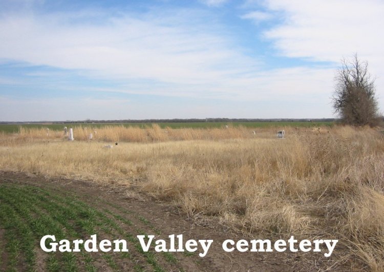
| Description | : | This cemetery is located in Garden Township, Harvey County, Kansas Section 24. From I-135 take Hwy 50 West to County Road 801. You will find County Road 801 about a mile past the Halstead Cemetery. Take CR801 north for 6 miles and then go 1 mile east on NW 60th (dirt road) then go north 1/2 mile. The cemetery is off the road in a field on the east side of the road. There is no fence around this cemetery and it is in very bad shape. Nearly every tombstone there is broken and worn. |
frequently asked questions (FAQ):
-
Where is Garden Valley Cemetery?
Garden Valley Cemetery is located at Harvey County ,Kansas ,USA.
-
Garden Valley Cemetery cemetery's updated grave count on graveviews.com?
2 memorials
-
Where are the coordinates of the Garden Valley Cemetery?
Latitude: 38.1232147
Longitude: -97.4998856
Nearby Cemetories:
1. Farnsworth-Cook Cemetery
Halstead, Harvey County, USA
Coordinate: 38.1233600, -97.4992200
2. Garden Community Church Cemetery
Halstead, Harvey County, USA
Coordinate: 38.1225900, -97.5188600
3. Garden View Mennonite Church Cemetery
Hesston, Harvey County, USA
Coordinate: 38.0874400, -97.5128900
4. Hesston Cemetery
Hesston, Harvey County, USA
Coordinate: 38.1448900, -97.4402400
5. Schlender Cemetery
Harvey County, USA
Coordinate: 38.1669006, -97.5374985
6. Whitestone Mennonite Church Columbarium
Hesston, Harvey County, USA
Coordinate: 38.1458950, -97.4297920
7. Church of God of The Firstborn Cemetery
Emma Township, Harvey County, USA
Coordinate: 38.0940100, -97.4269800
8. First Mennonite Cemetery
Moundridge, McPherson County, USA
Coordinate: 38.1885090, -97.5094070
9. Fairview Cemetery
Harvey County, USA
Coordinate: 38.0574100, -97.5186100
10. Lohrentz Cemetery
Harvey County, USA
Coordinate: 38.1518374, -97.5843430
11. West Zion Cemetery
Moundridge, McPherson County, USA
Coordinate: 38.2028008, -97.5372009
12. Mound Township Cemetery
Moundridge, McPherson County, USA
Coordinate: 38.2028008, -97.5378036
13. Eastlawn Cemetery
Zimmerdale, Harvey County, USA
Coordinate: 38.1151100, -97.3902900
14. Freedom Baptist Church Cemetery
McPherson County, USA
Coordinate: 38.2027400, -97.4362500
15. Halstead Cemetery Mausoleum
Halstead, Harvey County, USA
Coordinate: 38.0287000, -97.5002400
16. Halstead Cemetery
Halstead, Harvey County, USA
Coordinate: 38.0264015, -97.4989014
17. Meridian Cemetery
McPherson County, USA
Coordinate: 38.1741028, -97.3904722
18. Hopefield Church Cemetery
Moundridge, McPherson County, USA
Coordinate: 38.2105180, -97.5858040
19. Highland Cemetery
Newton, Harvey County, USA
Coordinate: 38.1440540, -97.3531320
20. Old Halstead Cemetery
Harvey County, USA
Coordinate: 38.0067350, -97.5297160
21. Restlawn Gardens of Memory Cemetery
Newton, Harvey County, USA
Coordinate: 38.0275002, -97.4075012
22. Faith Mennonite Church Columbarium
Newton, Harvey County, USA
Coordinate: 38.0672700, -97.3547700
23. Church of God of the Firstborn Cemetery
Harvey County, USA
Coordinate: 38.0142400, -97.4073500
24. Royer Cemetery
Newton, Harvey County, USA
Coordinate: 38.0139008, -97.4068985

