
| Memorials | : | 0 |
| Location | : | Louisville, Jefferson County, USA |
| Coordinate | : | 38.2369210, -85.4455730 |
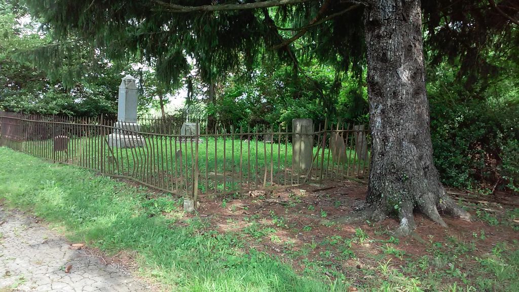
| Description | : | From Shelbyville Road east, turn left onto Flat Rock Road. Go .2 miles, then turn left onto Cotswald Green, entering the Gardiner Park subdivision. Turn left onto Buckland Trace (this goes around a circle to the left, and up a slight hill; continue around the circle to the right). The cemetery is enclosed by an iron fence, surrounded by trees. This is also known as the Pearce-Taylor cemetery. (submitted by Ellen White) |
frequently asked questions (FAQ):
-
Where is Gardiner Family Cemetery?
Gardiner Family Cemetery is located at Near Flat Rock and Shelbyville Roads Louisville, Jefferson County ,Kentucky , 40245USA.
-
Gardiner Family Cemetery cemetery's updated grave count on graveviews.com?
0 memorials
-
Where are the coordinates of the Gardiner Family Cemetery?
Latitude: 38.2369210
Longitude: -85.4455730
Nearby Cemetories:
1. Eastwood Cemetery #2
Louisville, Jefferson County, USA
Coordinate: 38.2387543, -85.4448776
2. Eastwood Cemetery
Louisville, Jefferson County, USA
Coordinate: 38.2336030, -85.4478090
3. Bull Skin Creek Burial Ground
Eastwood, Jefferson County, USA
Coordinate: 38.2319700, -85.4517200
4. Crask-Hobbs Cemetery
Long Run, Jefferson County, USA
Coordinate: 38.2249110, -85.4303210
5. Walden Cemetery
Long Run, Jefferson County, USA
Coordinate: 38.2657200, -85.4317400
6. Long Run Cemetery
Eastwood, Jefferson County, USA
Coordinate: 38.2549220, -85.4131310
7. Jackson Family Cemetery
Louisville, Jefferson County, USA
Coordinate: 38.2782823, -85.4420730
8. Pleasant Grove Cemetery
Anchorage, Jefferson County, USA
Coordinate: 38.2585280, -85.4970430
9. James Ward Cemetery
Louisville, Jefferson County, USA
Coordinate: 38.2796580, -85.4840650
10. Mount Zion Lutheran Cemetery
Jeffersontown, Jefferson County, USA
Coordinate: 38.2114582, -85.5049585
11. Taylor Family Cemetery
Fisherville, Jefferson County, USA
Coordinate: 38.1840533, -85.4328461
12. Flat Rock Christian Church Cemetery
Louisville, Jefferson County, USA
Coordinate: 38.2866600, -85.4168200
13. Allen Cemetery
Louisville, Jefferson County, USA
Coordinate: 38.2893030, -85.4784340
14. Floyds Fork Burying Ground
Fisherville, Jefferson County, USA
Coordinate: 38.1812010, -85.4782440
15. Yager Cemetery #1
Floydsburg, Oldham County, USA
Coordinate: 38.3006859, -85.4574203
16. Bradshaw Cemetery
Crestwood, Oldham County, USA
Coordinate: 38.3015000, -85.4342780
17. Berrytown Cemetery
Louisville, Jefferson County, USA
Coordinate: 38.2689200, -85.5204960
18. Blankenbeker Cemetery
Jeffersontown, Jefferson County, USA
Coordinate: 38.1995380, -85.5171550
19. Confederate Cemetery
Pewee Valley, Oldham County, USA
Coordinate: 38.3032990, -85.4760971
20. Pewee Valley Cemetery
Pewee Valley, Oldham County, USA
Coordinate: 38.3044014, -85.4749985
21. Pewee Valley East Cemetery
Pewee Valley, Oldham County, USA
Coordinate: 38.3044444, -85.4752778
22. Hopewell Cemetery
Jeffersontown, Jefferson County, USA
Coordinate: 38.1862660, -85.5103680
23. Blankenbaker Family Cemetery
Jeffersontown, Jefferson County, USA
Coordinate: 38.2160100, -85.5340500
24. Orr Cemetery
Jeffersontown, Jefferson County, USA
Coordinate: 38.2150900, -85.5338200