
| Memorials | : | 0 |
| Location | : | Bolesławiec, Powiat bolesławiecki, Poland |
| Coordinate | : | 50.9795019, 15.3471404 |
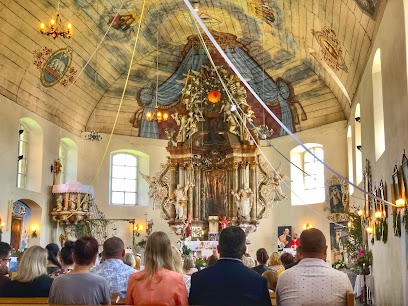
| Description | : | The first wooden church in Giebułtów (formerly Gebhardsdorf) was founded in the 14th century. This structure was burned by the Hussites in 1431. A new church was constructed on the initiative of the Dominican friar and nemesis of Martin Luther, Johann Tetzel, using funds he collected through the sale of Indulgences. After the Reformation church passed into the hands of the Protestant church when the village and its lord converted. It became a center for Protestant worship for faithful from other parts of Silesia where that religion was banned. The church was expanded in 1704 to accommodate the increased number... Read More |
frequently asked questions (FAQ):
-
Where is Giebułtów Church of St. Michael?
Giebułtów Church of St. Michael is located at Giebułtów Bolesławiec, Powiat bolesławiecki ,Dolnośląskie ,Poland.
-
Giebułtów Church of St. Michael cemetery's updated grave count on graveviews.com?
0 memorials
-
Where are the coordinates of the Giebułtów Church of St. Michael?
Latitude: 50.9795019
Longitude: 15.3471404
Nearby Cemetories:
1. Church of the Annunciation
Mirsk, Powiat lwówecki, Poland
Coordinate: 50.9689700, 15.3814000
2. Wolimierz Church Graveyard
Bolesławiec, Powiat bolesławiecki, Poland
Coordinate: 50.9578400, 15.3179800
3. Pobieda Communal Cemetery
Bolesławiec, Powiat bolesławiecki, Poland
Coordinate: 50.9362300, 15.2939900
4. Wieża Protestant Cemetery
Bolesławiec, Powiat bolesławiecki, Poland
Coordinate: 51.0247600, 15.4092000
5. Church of St. Anthony
Biedrzychowice, Powiat lubański, Poland
Coordinate: 51.0391408, 15.3796510
6. Church of St. Hedwig
Gryfów Śląski, Powiat lwówecki, Poland
Coordinate: 51.0292397, 15.4152342
7. Rębiszów Catholic Church Graveyard
Bolesławiec, Powiat bolesławiecki, Poland
Coordinate: 50.9532800, 15.4434700
8. Gryfów Śląski Cemetery
Wrocław, Miasto Wrocław, Poland
Coordinate: 51.0313300, 15.4139900
9. Leśna Evangelical Cemetery
Bolesławiec, Powiat bolesławiecki, Poland
Coordinate: 51.0255000, 15.2608700
10. Grabiszyce Średnie Catholic Graveyard
Bolesławiec, Powiat bolesławiecki, Poland
Coordinate: 51.0158200, 15.2004200
11. Lubomierz Cemetery
Bolesławiec, Powiat bolesławiecki, Poland
Coordinate: 51.0157900, 15.5053200
12. Kościelnik Church of St. John the Baptist
Bolesławiec, Powiat bolesławiecki, Poland
Coordinate: 51.0849840, 15.2981083
13. Rząsiny Church of the Assumption Graveyard
Bolesławiec, Powiat bolesławiecki, Poland
Coordinate: 51.0812200, 15.4383600
14. Janice Protestant Cemetery
Bolesławiec, Powiat bolesławiecki, Poland
Coordinate: 50.9563051, 15.5339381
15. Mała Kamienica Church of St. Barbara
Bolesławiec, Powiat bolesławiecki, Poland
Coordinate: 50.9098210, 15.5433361
16. Lubań Communal Cemetery
Bolesławiec, Powiat bolesławiecki, Poland
Coordinate: 51.1271600, 15.2924400
17. Stara Kamienica Church of St. John the Baptist
Bolesławiec, Powiat bolesławiecki, Poland
Coordinate: 50.9196557, 15.5718010
18. Kopaniec Church of St. Anthony of Padua
Bolesławiec, Powiat bolesławiecki, Poland
Coordinate: 50.8921302, 15.5516039
19. Barcinek Church of St. Michael
Bolesławiec, Powiat bolesławiecki, Poland
Coordinate: 50.9397320, 15.5957866
20. Church of St. Hedwig
Niwnice, Powiat lwówecki, Poland
Coordinate: 51.1183700, 15.4872700
21. Radomice Church of Sts. James and Catherine
Bolesławiec, Powiat bolesławiecki, Poland
Coordinate: 50.9922307, 15.6085615
22. Pławna Dolna Church Graveyard
Bolesławiec, Powiat bolesławiecki, Poland
Coordinate: 51.0513800, 15.5878000
23. Siekierczyn Church of St. Anthony
Bolesławiec, Powiat bolesławiecki, Poland
Coordinate: 51.1179159, 15.1944265
24. Kromnów Church of St. George
Bolesławiec, Powiat bolesławiecki, Poland
Coordinate: 50.8955308, 15.5792439