
| Memorials | : | 398 |
| Location | : | Orange, Orange County, USA |
| Coordinate | : | 38.2433014, -78.1267014 |
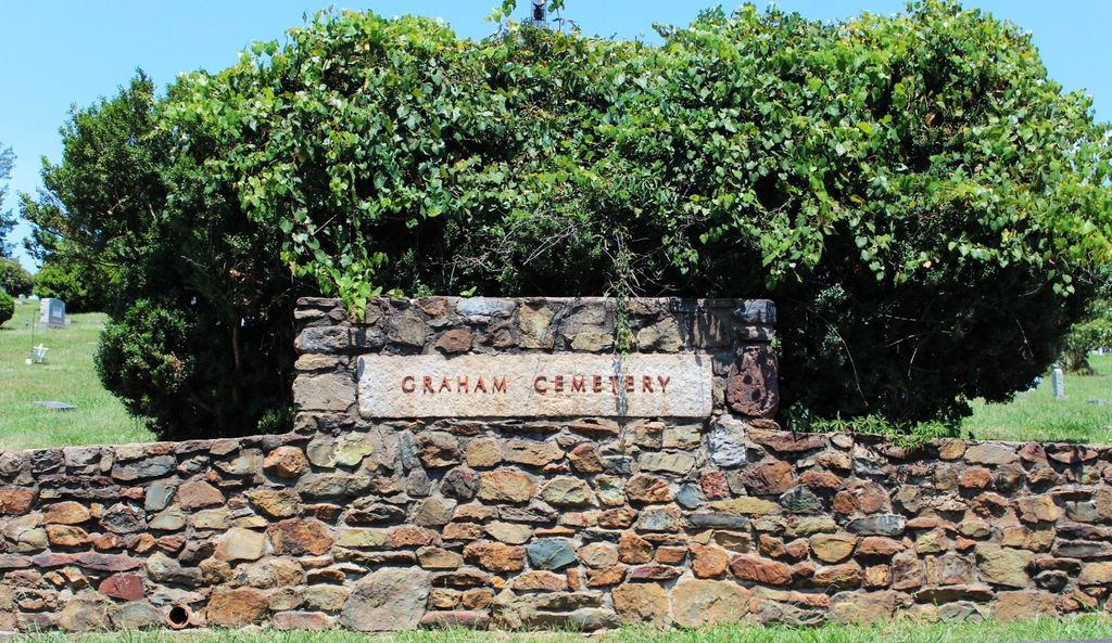
| Description | : | A deed dated August 4, 1868, a Mr. Richard Boulware conveyed five acres of land located just west of the Town of Orange and on the Orange to Montpelier road to Alexander Daley, E.W. Rowe and W.G. Williams to hold the same in trust and to administer it as a graveyard. A Mr. David Graham contributed the purchase price of the land, which act is thought to be why the cemetery was named Graham Cemetery. Although the cemetery was not deeded into existence until after the Civil War, the land was used for burying soldiers who died in the Orange Court... Read More |
frequently asked questions (FAQ):
-
Where is Graham Cemetery?
Graham Cemetery is located at 14293 Constitution Highway (Rt. 20) Orange, Orange County ,Virginia , 22960USA.
-
Graham Cemetery cemetery's updated grave count on graveviews.com?
376 memorials
-
Where are the coordinates of the Graham Cemetery?
Latitude: 38.2433014
Longitude: -78.1267014
Nearby Cemetories:
1. Westview Cemetery
Orange, Orange County, USA
Coordinate: 38.2428017, -78.1303024
2. Saint Thomas Episcopal Church Cemetery
Orange, Orange County, USA
Coordinate: 38.2437740, -78.1128630
3. Greenfield Cemetery
Orange, Orange County, USA
Coordinate: 38.2533500, -78.1003900
4. Dade - Cason - Kemper Cemetery
Orange, Orange County, USA
Coordinate: 38.2720000, -78.1367600
5. Munday Cemetery
Orange County, USA
Coordinate: 38.2640720, -78.0973980
6. Kemper Family Cemetery
Orange, Orange County, USA
Coordinate: 38.2742004, -78.1547012
7. Saint Isidore The Farmer Catholic Church Cemetery
Orange, Orange County, USA
Coordinate: 38.2049390, -78.1353760
8. Taylor Family Cemetery
Orange, Orange County, USA
Coordinate: 38.2289770, -78.0785470
9. Montpelier Slave Cemetery
Montpelier Station, Orange County, USA
Coordinate: 38.2196010, -78.1726330
10. Madison-Taliaferro Family Cemetery
Madison Mills, Madison County, USA
Coordinate: 38.2856700, -78.1418200
11. Gilmore Cemetery
Orange, Orange County, USA
Coordinate: 38.2273270, -78.1801920
12. Montpelier Estate National Historic Site
Montpelier Station, Orange County, USA
Coordinate: 38.2177730, -78.1748230
13. Zion Baptist Church
Orange, Orange County, USA
Coordinate: 38.1957990, -78.1322480
14. Woodberry Forest School Columbarium
Five Forks, Madison County, USA
Coordinate: 38.2909930, -78.1229230
15. Pierce Family Cemetery
Orange, Orange County, USA
Coordinate: 38.2325570, -78.0576850
16. Jerdone Cemetery
Orange, Orange County, USA
Coordinate: 38.2565280, -78.0561670
17. Taylor-Quarles Family Cemetery
Orange, Orange County, USA
Coordinate: 38.2562940, -78.0539430
18. Walkers Methodist Church Cemetery
Radiant, Madison County, USA
Coordinate: 38.2932870, -78.1680700
19. Jacksontown Cemetery
Somerset, Orange County, USA
Coordinate: 38.2034250, -78.1928690
20. Mount Pisgah Baptist Church Cemetery
Tanners, Madison County, USA
Coordinate: 38.3072900, -78.1519200
21. Johnson Cemetery
Burnt Tree, Madison County, USA
Coordinate: 38.3025390, -78.1721370
22. Lee Family Cemetery
Old Somerset, Orange County, USA
Coordinate: 38.2227900, -78.2192720
23. Scott Family Cemetery
Gordonsville, Orange County, USA
Coordinate: 38.1676940, -78.1416220
24. Rose Hill Cemetery
Orange County, USA
Coordinate: 38.3126370, -78.0764850