
| Memorials | : | 0 |
| Location | : | Gravesend, Gravesham Borough, England |
| Phone | : | 01474 328249 |
| Coordinate | : | 51.4418776, 0.3721993 |
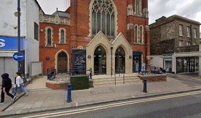
| Description | : | The Methodist Church was established in 1812, with the current building being constructed on the site in 1906, as the previous one was inadequate for its needs. This site may have once been known as the Ebenezer Chapel (also located on Milton Road). Today, no sign of the original Ebenezer Chapel remains. |
frequently asked questions (FAQ):
-
Where is Gravesend Methodist Churchyard?
Gravesend Methodist Churchyard is located at Milton Road Gravesend, Gravesham Borough ,Kent , DA12 2REEngland.
-
Gravesend Methodist Churchyard cemetery's updated grave count on graveviews.com?
0 memorials
-
Where are the coordinates of the Gravesend Methodist Churchyard?
Latitude: 51.4418776
Longitude: 0.3721993
Nearby Cemetories:
1. St George Churchyard
Gravesend, Gravesham Borough, England
Coordinate: 51.4441060, 0.3683350
2. Gravesend War Memorial
Gravesend, Gravesham Borough, England
Coordinate: 51.4362650, 0.3720650
3. St. Peter and St. Paul Churchyard
Gravesend, Gravesham Borough, England
Coordinate: 51.4391441, 0.3854820
4. Christ Church Milton-next-Gravesend
Gravesend, Gravesham Borough, England
Coordinate: 51.4317570, 0.3769340
5. Gravesend Cemetery
Gravesend, Gravesham Borough, England
Coordinate: 51.4345220, 0.3596280
6. Tilbury Fort
Tilbury, Thurrock Unitary Authority, England
Coordinate: 51.4526160, 0.3745650
7. Milton-next-Gravesend War Memorial
Gravesend, Gravesham Borough, England
Coordinate: 51.4389950, 0.3896110
8. All Saints Churchyard
Northfleet, Gravesham Borough, England
Coordinate: 51.4334679, 0.3513570
9. St Botolph Churchyard
Northfleet, Gravesham Borough, England
Coordinate: 51.4429910, 0.3347090
10. Northfleet Cemetery
Northfleet, Gravesham Borough, England
Coordinate: 51.4345551, 0.3333960
11. St Mary the Virgin Churchyard
Chalk, Gravesham Borough, England
Coordinate: 51.4265213, 0.4195510
12. St James Churchyard
West Tilbury, Thurrock Unitary Authority, England
Coordinate: 51.4739320, 0.3908730
13. St. Margaret Churchyard
Cobham, Gravesham Borough, England
Coordinate: 51.4059906, 0.3749080
14. St Stephen
Twickenham, London Borough of Richmond upon Thames, England
Coordinate: 51.4534000, 0.3130400
15. St Mary the Virgin Churchyard
Little Thurrock, Thurrock Unitary Authority, England
Coordinate: 51.4756980, 0.3402920
16. St. Mary's Churchyard
Chadwell St Mary, Thurrock Unitary Authority, England
Coordinate: 51.4815470, 0.3691580
17. St Peter and St Paul Churchyard
Swanscombe, Dartford Borough, England
Coordinate: 51.4422302, 0.3074830
18. Swanscombe Cemetery
Swanscombe, Dartford Borough, England
Coordinate: 51.4424200, 0.3074220
19. Swanscombe War Memorial
Swanscombe, Dartford Borough, England
Coordinate: 51.4426422, 0.3062360
20. St Nicholas Churchyard
Southfleet, Dartford Borough, England
Coordinate: 51.4165030, 0.3193850
21. St. Catherine's Churchyard
East Tilbury, Thurrock Unitary Authority, England
Coordinate: 51.4664730, 0.4303230
22. Chadwell St Mary Cemetery
Chadwell St Mary, Thurrock Unitary Authority, England
Coordinate: 51.4858260, 0.3695060
23. Grays New Cemetery
Grays, Thurrock Unitary Authority, England
Coordinate: 51.4843130, 0.3460480
24. St Peter and St Paul Churchyard
Grays, Thurrock Unitary Authority, England
Coordinate: 51.4755400, 0.3221700