
| Memorials | : | 66 |
| Location | : | Grays, Thurrock Unitary Authority, England |
| Coordinate | : | 51.4755400, 0.3221700 |
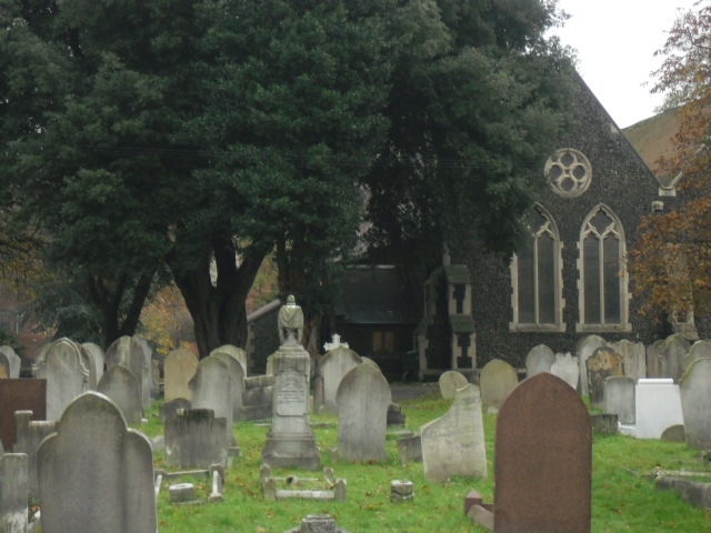
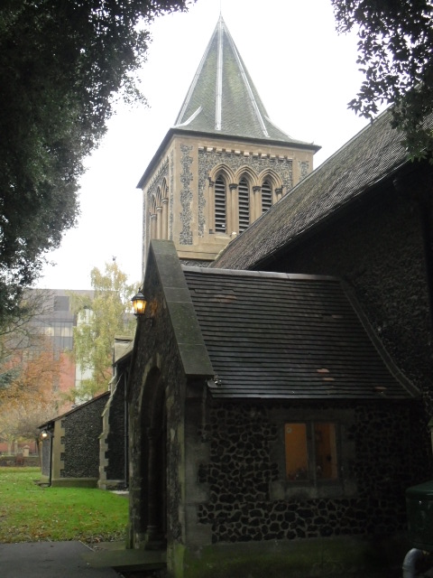
| Description | : | Although there is no structural evidence of a Saxon church, the first firm evidence of a church in Grays is 1040, when a priest, Wulfstan the Wild One, inherited the Manor of Thurrock. The earliest architectural style identified in the present structure and in old drawings is Norman, and it has been concluded that the oldest part of the present building dates from a few years either side of 1100, and consists of the present chancel and part of the nave built by the Peverels, who were then Lords of the Manor. Sometime between 1152 and 1159, the church was given... Read More |
frequently asked questions (FAQ):
-
Where is St Peter and St Paul Churchyard?
St Peter and St Paul Churchyard is located at High Street/New Road Grays, Thurrock Unitary Authority ,Essex , RM17 6LNEngland.
-
St Peter and St Paul Churchyard cemetery's updated grave count on graveviews.com?
66 memorials
-
Where are the coordinates of the St Peter and St Paul Churchyard?
Latitude: 51.4755400
Longitude: 0.3221700
Nearby Cemetories:
1. St Mary the Virgin Churchyard
Little Thurrock, Thurrock Unitary Authority, England
Coordinate: 51.4756980, 0.3402920
2. Grays New Cemetery
Grays, Thurrock Unitary Authority, England
Coordinate: 51.4843130, 0.3460480
3. St. Clement's Churchyard
West Thurrock, Thurrock Unitary Authority, England
Coordinate: 51.4722010, 0.2924900
4. St Stephen
Twickenham, London Borough of Richmond upon Thames, England
Coordinate: 51.4534000, 0.3130400
5. Hammersmith New Cemetery
Hammersmith, London Borough of Hammersmith and Fulham, England
Coordinate: 51.4710900, 0.2752400
6. St. Mary's Churchyard
Chadwell St Mary, Thurrock Unitary Authority, England
Coordinate: 51.4815470, 0.3691580
7. Chadwell St Mary Cemetery
Chadwell St Mary, Thurrock Unitary Authority, England
Coordinate: 51.4858260, 0.3695060
8. St Botolph Churchyard
Northfleet, Gravesham Borough, England
Coordinate: 51.4429910, 0.3347090
9. Swanscombe War Memorial
Swanscombe, Dartford Borough, England
Coordinate: 51.4426422, 0.3062360
10. Swanscombe Cemetery
Swanscombe, Dartford Borough, England
Coordinate: 51.4424200, 0.3074220
11. St Peter and St Paul Churchyard
Swanscombe, Dartford Borough, England
Coordinate: 51.4422302, 0.3074830
12. Tilbury Fort
Tilbury, Thurrock Unitary Authority, England
Coordinate: 51.4526160, 0.3745650
13. Northfleet Cemetery
Northfleet, Gravesham Borough, England
Coordinate: 51.4345551, 0.3333960
14. St. Mary the Virgin Churchyard
Stone, Dartford Borough, England
Coordinate: 51.4503160, 0.2673630
15. St George Churchyard
Gravesend, Gravesham Borough, England
Coordinate: 51.4441060, 0.3683350
16. St James Churchyard
West Tilbury, Thurrock Unitary Authority, England
Coordinate: 51.4739320, 0.3908730
17. All Saints Churchyard
Northfleet, Gravesham Borough, England
Coordinate: 51.4334679, 0.3513570
18. Gravesend Methodist Churchyard
Gravesend, Gravesham Borough, England
Coordinate: 51.4418776, 0.3721993
19. St. Michael’s Churchyard
Aveley, Thurrock Unitary Authority, England
Coordinate: 51.4980160, 0.2568560
20. St. Giles and All Saints Churchyard
Orsett, Thurrock Unitary Authority, England
Coordinate: 51.5127200, 0.3683180
21. Gravesend Cemetery
Gravesend, Gravesham Borough, England
Coordinate: 51.4345220, 0.3596280
22. South Ockendon Cemetery
South Ockendon, Thurrock Unitary Authority, England
Coordinate: 51.5226000, 0.2988650
23. St. Nicholas Churchyard
South Ockendon, Thurrock Unitary Authority, England
Coordinate: 51.5224830, 0.2976820
24. Gravesend War Memorial
Gravesend, Gravesham Borough, England
Coordinate: 51.4362650, 0.3720650