
| Memorials | : | 0 |
| Location | : | Regensburg, Stadtkreis Regensburg, Germany |
| Coordinate | : | 49.0150320, 12.0928040 |
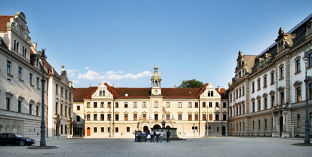
| Description | : | St. Emmeram's Abbey, now known as Schloss Thurn und Taxis and St. Emmeram's Basilica, was a Benedictine monastery founded in about 739 in Regensburg in Bavaria at the grave of the itinerant Frankish bishop Saint Emmeram. In 1295 the counter-king Adolf of Nassau granted the abbey the regalia and made it an Imperial abbey, an independent sovereign power subject directly to the emperor. In 1731, the abbots were raised to the status of Princes of the Empire (Reichsfürsten). Between 1731 and 1733 there followed the magnificent Baroque refurbishment, by the Asam brothers, of the abbey church, which had been repeatedly... Read More |
frequently asked questions (FAQ):
-
Where is Gruftkapelle St. Emmeram?
Gruftkapelle St. Emmeram is located at Emmeramsplatz 3, Regensburg, Stadtkreis Regensburg ,Bavaria (Bayern) , 93047Germany.
-
Gruftkapelle St. Emmeram cemetery's updated grave count on graveviews.com?
0 memorials
-
Where are the coordinates of the Gruftkapelle St. Emmeram?
Latitude: 49.0150320
Longitude: 12.0928040
Nearby Cemetories:
1. Gesandtenfriedhof
Regensburg, Stadtkreis Regensburg, Germany
Coordinate: 49.0183985, 12.0918603
2. Regensburg Evangelischer Zentralfriedhof
Regensburg, Stadtkreis Regensburg, Germany
Coordinate: 49.0098700, 12.0958200
3. Evangelischer Zentralfriedhof
Regensburg, Stadtkreis Regensburg, Germany
Coordinate: 49.0098000, 12.0958800
4. St. Johann
Regensburg, Stadtkreis Regensburg, Germany
Coordinate: 49.0197890, 12.0975142
5. Peterskirchlein
Regensburg, Stadtkreis Regensburg, Germany
Coordinate: 49.0129410, 12.1008740
6. Kathedrale St. Peter
Regensburg, Stadtkreis Regensburg, Germany
Coordinate: 49.0194940, 12.0981920
7. Minoritenkirche
Regensburg, Stadtkreis Regensburg, Germany
Coordinate: 49.0180560, 12.1019440
8. Stift Niedermünster
Regensburg, Stadtkreis Regensburg, Germany
Coordinate: 49.0195750, 12.1007610
9. Oberer Katholischer Friedhof Regensburg
Regensburg, Stadtkreis Regensburg, Germany
Coordinate: 49.0069900, 12.0950900
10. Maria-Schutz Kirche
Regensburg, Stadtkreis Regensburg, Germany
Coordinate: 49.0190090, 12.0803710
11. Cemetery of Saint Lazarus (Defunct)
Regensburg, Stadtkreis Regensburg, Germany
Coordinate: 49.0187710, 12.0792830
12. Unterer Katholischer Friedhof Regensburg
Regensburg, Stadtkreis Regensburg, Germany
Coordinate: 49.0075990, 12.1074430
13. Friedhof Ziegetsdorf
Regensburg, Stadtkreis Regensburg, Germany
Coordinate: 48.9924150, 12.0712360
14. Friedhof Sinzing
Sinzing, Landkreis Regensburg, Germany
Coordinate: 48.9929001, 12.0343558
15. Kirchlicher Friedhof Eilsbrunn
Eilsbrunn, Landkreis Regensburg, Germany
Coordinate: 49.0044463, 11.9752872
16. Friedhof Neutraubling
Neutraubling, Landkreis Regensburg, Germany
Coordinate: 48.9875328, 12.2067483
17. Friedhof Abbach
Bad Abbach, Landkreis Kelheim, Germany
Coordinate: 48.9350284, 12.0521349
18. Friedhof Bergmatting
Bergmatting, Landkreis Regensburg, Germany
Coordinate: 48.9692808, 11.9813400
19. Friedhof Nittendorf
Nittendorf, Landkreis Regensburg, Germany
Coordinate: 49.0252320, 11.9604270
20. Friedhof Viehhausen
Viehhausen, Landkreis Regensburg, Germany
Coordinate: 48.9799884, 11.9625860
21. Alter Friedhof Regenstauf
Regenstauf, Landkreis Regensburg, Germany
Coordinate: 49.1202835, 12.1260488
22. Friedhof Kapfelberg
Kapfelberg, Landkreis Kelheim, Germany
Coordinate: 48.9313645, 11.9841941
23. Neuer Friedhof Regenstauf
Regenstauf, Landkreis Regensburg, Germany
Coordinate: 49.1333342, 12.1292860
24. Friedhof Saal Donau
Saal an der Donau, Landkreis Kelheim, Germany
Coordinate: 48.9008500, 11.9396400