
| Memorials | : | 0 |
| Location | : | Heber, Navajo County, USA |
| Coordinate | : | 34.3056700, -110.7333300 |
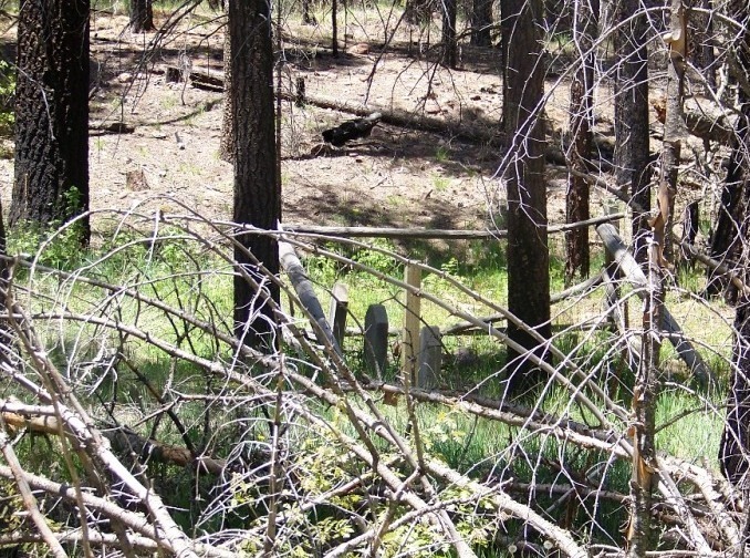
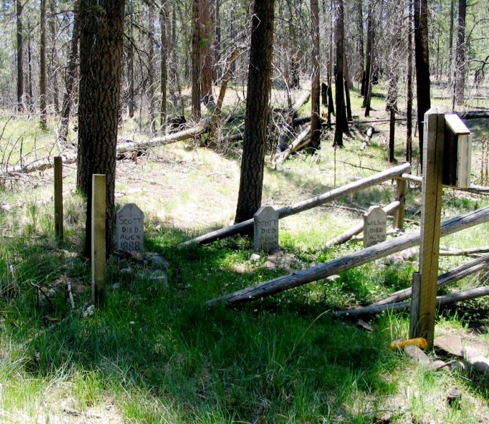
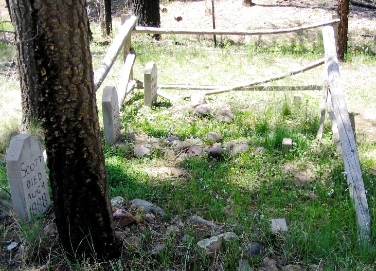
| Description | : | During the violent and bloody Pleasant Valley War, known also as the Graham-Tewksbury Feud, the three cowboys buried here were under the arrest and protection of J. D. Houck, a sheep man and some time law enforcement officer. The three had perfectly good alibis for the offense which they were accused and Houck was aware the men were innocent. En route to Prescott a group of masked vigilantes known as the Committee of Fifty intercepted the posse and made off with the prisoners. The posse and the vigilantes were in cahoots and it was all prearranged. The three men were... Read More |
frequently asked questions (FAQ):
-
Where is Hangman Trail Burial Ground?
Hangman Trail Burial Ground is located at Heber, Navajo County ,Arizona ,USA.
-
Hangman Trail Burial Ground cemetery's updated grave count on graveviews.com?
0 memorials
-
Where are the coordinates of the Hangman Trail Burial Ground?
Latitude: 34.3056700
Longitude: -110.7333300
Nearby Cemetories:
1. Baca Family Cemetery
Heber, Navajo County, USA
Coordinate: 34.3229000, -110.6864700
2. J Redman Gravesite
Young, Gila County, USA
Coordinate: 34.1866200, -110.7836400
3. Gordon Canyon Cemetery
Gila County, USA
Coordinate: 34.2816100, -110.9177600
4. Heber Cemetery
Heber, Navajo County, USA
Coordinate: 34.4274635, -110.6049194
5. Overgaard Baby Cemetery
Overgaard, Navajo County, USA
Coordinate: 34.4011000, -110.5582900
6. Q Ranch Historic Cemetery
Young, Gila County, USA
Coordinate: 34.1024990, -110.8104400
7. Navajo Sheepherder Gravesite
Young, Gila County, USA
Coordinate: 34.1498010, -110.9328620
8. Grant Roadside Gravesite
Aripine, Navajo County, USA
Coordinate: 34.4258995, -110.4132767
9. Tewksbury-Jacobs Gravesite
Young, Gila County, USA
Coordinate: 34.0494330, -110.8987417
10. Cibecue Northwest Cemetery
Cibecue, Navajo County, USA
Coordinate: 34.0638700, -110.4978300
11. Clay Springs Cemetery
Clay Springs, Navajo County, USA
Coordinate: 34.3686500, -110.2988300
12. Pinedale Cemetery
Pinedale, Navajo County, USA
Coordinate: 34.3068000, -110.2467000
13. Haught Ranch Pioneer Cemetery
Rye, Gila County, USA
Coordinate: 34.0712090, -111.2155533
14. Big Dry Wash Battlefield
Coconino County, USA
Coordinate: 34.5461230, -111.2206610
15. Frost Family Cemetery
Linden, Navajo County, USA
Coordinate: 34.2932816, -110.1576004
16. Burton Cemetery
Navajo County, USA
Coordinate: 34.3314800, -110.1494000
17. Mountain Meadows Memorial Park and Crematory
Payson, Gila County, USA
Coordinate: 34.1941986, -111.3153000
18. Gisela Cemetery
Gisela, Gila County, USA
Coordinate: 34.1010017, -111.2789993
19. Payson Pioneer Cemetery
Payson, Gila County, USA
Coordinate: 34.2352660, -111.3560490
20. Shumway Cemetery
Shumway, Navajo County, USA
Coordinate: 34.4077988, -110.0824966
21. Taylor Cemetery
Taylor, Navajo County, USA
Coordinate: 34.4644012, -110.0971985
22. Adair Cemetery
Show Low, Navajo County, USA
Coordinate: 34.2688500, -110.0647300
23. Brown Family Cemetery
Rye, Gila County, USA
Coordinate: 34.0862740, -111.3496390
24. Andres Moreno Gravesite
Coconino County, USA
Coordinate: 34.4524490, -111.3823150