
| Memorials | : | 0 |
| Location | : | Hereford, Deaf Smith County, USA |
| Website | : | www.texasescapes.com/WorldWarII/POW-Camp-Chapel-Hereford-Texas.htm |
| Coordinate | : | 34.7458000, -102.4250000 |
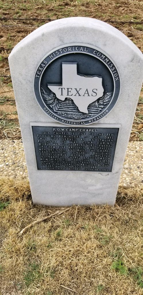
| Description | : | Italian POW Camp Chapel about 3.5 miles South of Hereford, Deaf Smith County, Texas near Umbarger, Randall County, Texas. Camp Hereford, known officially as the Hereford Military Reservation and Reception Center, was built in parts of Deaf Smith and Castro counties in the panhandle of Texas in 1942. The first POWs arrived at Hereford on April 3, 1943. The last prisoners left on Feb. 7, 1946. Camp Hereford was the second-largest POW camp built in the United States. |
frequently asked questions (FAQ):
-
Where is Hereford Italian POW Camp Chapel Grounds?
Hereford Italian POW Camp Chapel Grounds is located at 104 County Road 507 Hereford, Deaf Smith County ,Texas , 79045USA.
-
Hereford Italian POW Camp Chapel Grounds cemetery's updated grave count on graveviews.com?
0 memorials
-
Where are the coordinates of the Hereford Italian POW Camp Chapel Grounds?
Latitude: 34.7458000
Longitude: -102.4250000
Nearby Cemetories:
1. West Park Cemetery
Hereford, Deaf Smith County, USA
Coordinate: 34.8210983, -102.4206009
2. Saint Thomas Episcopal Church Columbarium
Hereford, Deaf Smith County, USA
Coordinate: 34.8217660, -102.4133190
3. Saint Anthonys Cemetery
Hereford, Deaf Smith County, USA
Coordinate: 34.8327600, -102.4100700
4. Rest Lawn Cemetery
Hereford, Deaf Smith County, USA
Coordinate: 34.8643990, -102.4049988
5. Westlawn Memorial Park
Dimmitt, Castro County, USA
Coordinate: 34.5380250, -102.3618610
6. Castro Memorial Gardens
Dimmitt, Castro County, USA
Coordinate: 34.5280991, -102.3197021
7. Old La Plata Cemetery
Hereford, Deaf Smith County, USA
Coordinate: 34.9695880, -102.5980060
8. Flagg Cemetery
Castro County, USA
Coordinate: 34.4393997, -102.3681030
9. Holy Family Cemetery
Nazareth, Castro County, USA
Coordinate: 34.5469017, -102.1025009
10. Palo Duro Wildorado
Deaf Smith County, USA
Coordinate: 35.1167700, -102.2047260
11. Hart Cemetery
Hart, Castro County, USA
Coordinate: 34.3926010, -102.1346970
12. Bailey County Cemetery
Muleshoe, Bailey County, USA
Coordinate: 34.2859600, -102.7661950
13. Hollene Cemetery
Hollene, Curry County, USA
Coordinate: 34.7774950, -103.0994210
14. Muleshoe Memorial Park Cemetery
Muleshoe, Bailey County, USA
Coordinate: 34.2634100, -102.7851800
15. Pleasant Hill Cemetery
Pleasant Hill, Curry County, USA
Coordinate: 34.5349998, -103.0733032
16. Mitchell Cemetery
Bellview, Curry County, USA
Coordinate: 34.9150009, -103.0991974
17. Allen Cemetery
Quay County, USA
Coordinate: 35.0120020, -103.1381030
18. West Camp Cemetery
Bailey County, USA
Coordinate: 34.2811012, -102.9757996
19. Texico Cemetery
Texico, Curry County, USA
Coordinate: 34.3758011, -103.0849991
20. Running Water Cemetery
Edmonson, Hale County, USA
Coordinate: 34.2602710, -101.8685960
21. Halfway Cemetery
Hale County, USA
Coordinate: 34.1875000, -101.9356003
22. Endee Cemetery
Quay County, USA
Coordinate: 35.1453018, -103.1247025
23. Lawn Haven Memorial Gardens Cemetery
Clovis, Curry County, USA
Coordinate: 34.4333000, -103.1856003
24. Wayside Cemetery
Wayside, Armstrong County, USA
Coordinate: 34.7919998, -101.5466003