
| Memorials | : | 0 |
| Location | : | Marion, Cole County, USA |
| Coordinate | : | 38.6776300, -92.3595600 |
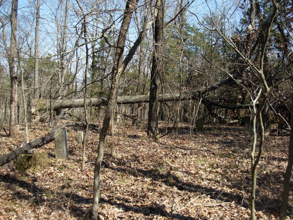
| Description | : | Located on the property of Bernice Taggart Township 45 North, Range 13 West, Section 4, N.W. 1/4 of S.W. 1/14 This cemetery is also known as the Hickam Cemetery, the Durham Cemetery and as the Taggart Cemetery. This cemetery is not maintained and is in very poor condition. There is a huge oak tree that has fallen across what appears to be the center of the cemetery. There is not a good road to the cemetery and it can only be accessed, through the owners driveway, by ATV. |
frequently asked questions (FAQ):
-
Where is Hickman Cemetery?
Hickman Cemetery is located at Marion, Cole County ,Missouri ,USA.
-
Hickman Cemetery cemetery's updated grave count on graveviews.com?
0 memorials
-
Where are the coordinates of the Hickman Cemetery?
Latitude: 38.6776300
Longitude: -92.3595600
Nearby Cemetories:
1. Bailey Farm Cemetery
Marion, Cole County, USA
Coordinate: 38.6680330, -92.3553800
2. Knife Cemetery
Marion, Cole County, USA
Coordinate: 38.6681200, -92.3417300
3. New Hope Cemetery
Marion, Cole County, USA
Coordinate: 38.6955872, -92.3943558
4. Old Marion Cemetery
Marion, Cole County, USA
Coordinate: 38.7065506, -92.3792801
5. Steeley Cemetery
Elston, Cole County, USA
Coordinate: 38.6530883, -92.3282420
6. Steeley Cemetery
Moniteau County, USA
Coordinate: 38.6530991, -92.3281021
7. Friedens Cemetery
Hartsburg, Boone County, USA
Coordinate: 38.6986000, -92.3087000
8. Elias Chambers Burial Ground
Elston, Cole County, USA
Coordinate: 38.6320600, -92.3362300
9. Goshen Primitive Baptist Church Cemetery
Wilton, Boone County, USA
Coordinate: 38.7346600, -92.3550000
10. Shull Cemetery
Moniteau County, USA
Coordinate: 38.7296982, -92.3972015
11. Shull Cemetery
Cole County, USA
Coordinate: 38.7296982, -92.3974991
12. Mary Ann Williams Cemetery
California, Moniteau County, USA
Coordinate: 38.6988200, -92.4327900
13. Chambers Cemetery
Elston, Cole County, USA
Coordinate: 38.6166153, -92.3853836
14. Bonds Chapel Cemetery
Hartsburg, Boone County, USA
Coordinate: 38.7093900, -92.2855200
15. Sweetwater Cemetery
Moniteau County, USA
Coordinate: 38.6567001, -92.4411011
16. Cole County Poor Farm Cemetery
Elston, Cole County, USA
Coordinate: 38.6141810, -92.3287310
17. Centertown Cemetery
Centertown, Cole County, USA
Coordinate: 38.6188660, -92.4031677
18. Elston Cemetery
Elston, Cole County, USA
Coordinate: 38.6134491, -92.3227310
19. Cook Cemetery
Moniteau County, USA
Coordinate: 38.7393990, -92.4080963
20. Shiloh Christian Church Cemetery
California, Moniteau County, USA
Coordinate: 38.6951800, -92.4502300
21. Kleindits Cemetery
Jefferson Township, Cole County, USA
Coordinate: 38.6240390, -92.2917600
22. New Saint Martin Catholic Cemetery
Saint Martins, Cole County, USA
Coordinate: 38.6032900, -92.3415420
23. Evangelical Lutheran Emanuel Cemetery
Centertown, Cole County, USA
Coordinate: 38.6173820, -92.4191208
24. Tranbarger Burial Ground
Jefferson City, Cole County, USA
Coordinate: 38.6347200, -92.2752800