
| Memorials | : | 2 |
| Location | : | Mount Vernon, Monroe County, USA |
| Coordinate | : | 35.4200974, -84.3763275 |
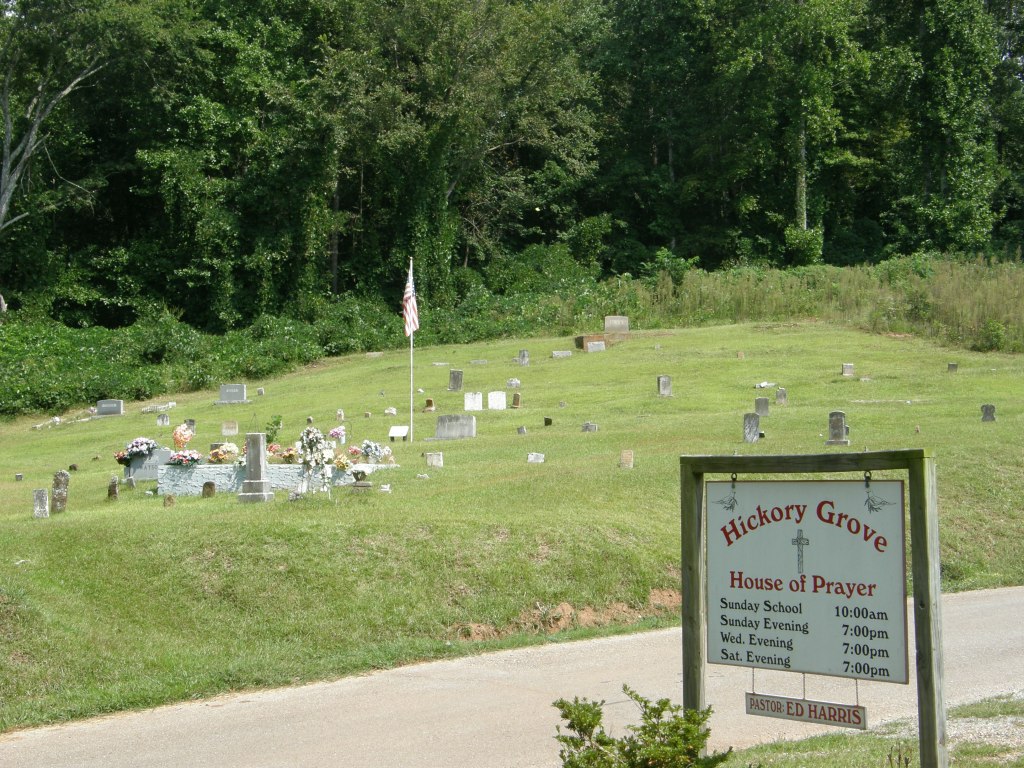
| Description | : | Located off of route 68 between Madisonville and Tellico Plains on Country Road 766 in Mt Vernon Community. This church was first organized about 1830 as the Hickory Grove Cumberland Presbyterian Church and reorganized in church capacity on October 5, 1899. Now called Hickory Grove House of Prayer, it is located off old HWY 68 between Madisonville and Tellico Plains on County Road 766 in Mt. Vernon Community. |
frequently asked questions (FAQ):
-
Where is Hickory Grove Cemetery?
Hickory Grove Cemetery is located at Mount Vernon, Monroe County ,Tennessee ,USA.
-
Hickory Grove Cemetery cemetery's updated grave count on graveviews.com?
2 memorials
-
Where are the coordinates of the Hickory Grove Cemetery?
Latitude: 35.4200974
Longitude: -84.3763275
Nearby Cemetories:
1. New Bethel Cemetery
Madisonville, Monroe County, USA
Coordinate: 35.4291992, -84.3867035
2. Eleazar Cemetery
Mount Vernon, Monroe County, USA
Coordinate: 35.4085999, -84.3527985
3. Sitzlar Family Cemetery
Mount Vernon, Monroe County, USA
Coordinate: 35.4074200, -84.3530900
4. Ebenezer Cemetery
Mount Vernon, Monroe County, USA
Coordinate: 35.4005210, -84.3999600
5. Bethlehem Cemetery
Monroe County, USA
Coordinate: 35.4371986, -84.3422012
6. Shoal Creek Baptist Church Cemetery
Tellico Plains, Monroe County, USA
Coordinate: 35.3846590, -84.3839480
7. Lands Chapel Cemetery
Monroe County, USA
Coordinate: 35.4043999, -84.4178009
8. Wilson Station Presbyterian Church Cemetery
Madisonville, Monroe County, USA
Coordinate: 35.4273940, -84.4215310
9. Notchey Creek Cemetery Old
Madisonville, Monroe County, USA
Coordinate: 35.4610000, -84.3710000
10. Notchey Creek Cemetery
Notchy Creek, Monroe County, USA
Coordinate: 35.4611015, -84.3713989
11. Rogers Cemetery
Monroe County, USA
Coordinate: 35.4103012, -84.3272018
12. Boyd Cemetery
Notchy Creek, Monroe County, USA
Coordinate: 35.4350830, -84.4279670
13. Mount Harmony Cemetery
Monroe County, USA
Coordinate: 35.3816760, -84.3480060
14. Fain Family Cemetery
McMinn County, USA
Coordinate: 35.4630013, -84.3928986
15. Piney Grove Baptist Church Cemetery
Monroe County, USA
Coordinate: 35.4177700, -84.3201000
16. Monroe County Paupers Cemetery
Madisonville, Monroe County, USA
Coordinate: 35.4697850, -84.3895270
17. Burger Family Cemetery
McMinn County, USA
Coordinate: 35.3997993, -84.4394989
18. Joines-Wilson Family Cemetery
Monroe County, USA
Coordinate: 35.4686000, -84.4102000
19. Baker Cemetery
Monroe County, USA
Coordinate: 35.3737800, -84.3380200
20. Chestua Baptist Church Cemetery
Madisonville, Monroe County, USA
Coordinate: 35.4695000, -84.4088000
21. Chestua Campground Community Cemetery
Madisonville, Monroe County, USA
Coordinate: 35.4627991, -84.4233017
22. Liberty Hill Church of Christ Cemetery
Englewood, McMinn County, USA
Coordinate: 35.3852997, -84.4375000
23. Haven of Light Cemetery
Madisonville, Monroe County, USA
Coordinate: 35.4755960, -84.4069870
24. Gray Memorial Cemetery
Monroe County, USA
Coordinate: 35.3758940, -84.3193820