
| Memorials | : | 0 |
| Location | : | Burnsville, Anson County, USA |
| Coordinate | : | 35.1325500, -80.1941000 |
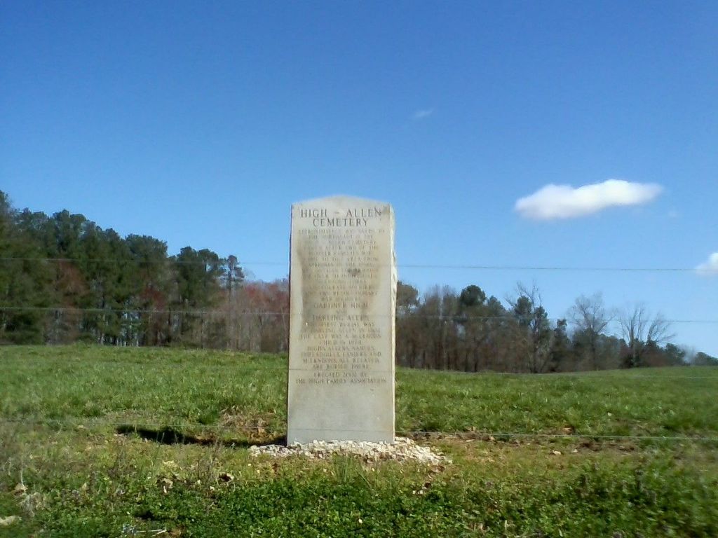
| Description | : | Approximately 300 yards to the northeast is the High-Allen Cemetery, named after two of the Pioneer families who came to this area from Virginia in the 1700's. It contains the remains of over 30 individuals including three Confederate soldiers and two Revolutionary War soldiers, Gardner High and Darling Allen. The first burial was of Darling Allen in 1802, the last was a McLendon child in 1874. Highs, Allens, Nances, Threadgills, Laniers and McLendons, all related, are buried there. Erected 2002 by The High Family Association |
frequently asked questions (FAQ):
-
Where is High-Allen Cemetery?
High-Allen Cemetery is located at Randall Rd Burnsville, Anson County ,North Carolina ,USA.
-
High-Allen Cemetery cemetery's updated grave count on graveviews.com?
0 memorials
-
Where are the coordinates of the High-Allen Cemetery?
Latitude: 35.1325500
Longitude: -80.1941000
Nearby Cemetories:
1. Rocky River Baptist Church Cemetery
Polkton, Anson County, USA
Coordinate: 35.1323540, -80.2019530
2. Wightman United Methodist Church Cemetery
Polkton, Anson County, USA
Coordinate: 35.1419525, -80.1939468
3. Fredrick Staton Cemetery
Burnsville, Anson County, USA
Coordinate: 35.1180560, -80.1886110
4. Drury Allen Cemetery
Anson County, USA
Coordinate: 35.1270940, -80.2120430
5. Poplar Springs Missionary Baptist Church Cemetery
Polkton, Anson County, USA
Coordinate: 35.1361198, -80.2205353
6. Red Hill Baptist Church Cemetery
Ansonville, Anson County, USA
Coordinate: 35.1076220, -80.1577950
7. Fairview Church of God Cemetery
Polkton, Anson County, USA
Coordinate: 35.1171133, -80.2484826
8. Cedar Grove Baptist Church Cemetery
Polkton, Anson County, USA
Coordinate: 35.0827400, -80.2084400
9. Concord United Methodist Church Cemetery
Ansonville, Anson County, USA
Coordinate: 35.1466610, -80.1338440
10. Cedar Hill AME Zion Church Cemetery
Ansonville, Anson County, USA
Coordinate: 35.1436100, -80.1281100
11. S Lilly Cemetery
Norwood, Stanly County, USA
Coordinate: 35.1739900, -80.1437200
12. Williams Cemetery
Burnsville, Anson County, USA
Coordinate: 35.0970200, -80.2571400
13. Cottonville AME Zion Cemetery
Norwood, Stanly County, USA
Coordinate: 35.1959960, -80.1887430
14. Mount Zion United Methodist Church Cemetery
Norwood, Stanly County, USA
Coordinate: 35.1896320, -80.1592460
15. Rocky Mount Baptist Church Cemetery
Polkton, Anson County, USA
Coordinate: 35.1758900, -80.2557900
16. Cottonville Baptist Church Cemetery
Norwood, Stanly County, USA
Coordinate: 35.1994340, -80.1888300
17. Benjamin Lilly Burial Ground
Norwood, Stanly County, USA
Coordinate: 35.1798167, -80.1345500
18. Hopewell Methodist Church Cemetery
Peachland, Anson County, USA
Coordinate: 35.0700500, -80.2325320
19. Edwards Family Cemetery
Anson County, USA
Coordinate: 35.1295220, -80.2810380
20. Kean-Meggs
Burnsville, Anson County, USA
Coordinate: 35.1329500, -80.2829700
21. Poplar Springs Cemetery
Norwood, Stanly County, USA
Coordinate: 35.1959667, -80.1492167
22. Gaddy-Allen-Threadgill Cemetery
Ansonville, Anson County, USA
Coordinate: 35.1275250, -80.1046820
23. Tucker Plantation Cemetery
Peachland, Anson County, USA
Coordinate: 35.0702670, -80.2443660
24. Jerusalem Primitive Baptist Church Cemetery
Burnsville, Anson County, USA
Coordinate: 35.1168000, -80.2836000