
| Memorials | : | 2 |
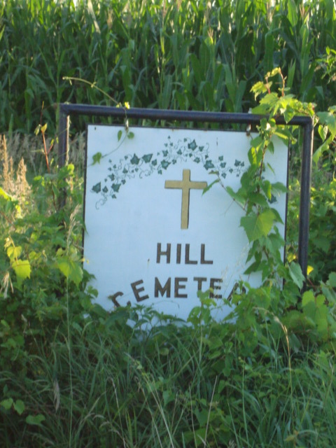
| Location | : | Norborne, Carroll County, USA |
| Coordinate | : | 39.2497000, -93.6725000 |
| Description | : | Cherry Valley Township |
frequently asked questions (FAQ):
-
Where is Hill Cemetery?
Hill Cemetery is located at Norborne, Carroll County ,Missouri ,USA.
-
Hill Cemetery cemetery's updated grave count on graveviews.com?
1 memorials
-
Where are the coordinates of the Hill Cemetery?
Latitude: 39.2497000
Longitude: -93.6725000
Nearby Cemetories:
1. Fairhaven Cemetery
Norborne, Carroll County, USA
Coordinate: 39.2991982, -93.6903000
2. Sacred Heart Cemetery
Norborne, Carroll County, USA
Coordinate: 39.2914009, -93.6247025
3. Gilead Cemetery
Norborne, Carroll County, USA
Coordinate: 39.2716780, -93.6059130
4. Dover Cemetery
Dover, Lafayette County, USA
Coordinate: 39.1920013, -93.6874008
5. Unnamed Cemetery #91
Carroll County, USA
Coordinate: 39.2658005, -93.5985031
6. Saint John's Cemetery
Dover, Lafayette County, USA
Coordinate: 39.1910200, -93.6864000
7. Watson Cemetery
Cherry Valley Township, Carroll County, USA
Coordinate: 39.2246000, -93.7438000
8. Unnamed Cemetery #85
Carroll County, USA
Coordinate: 39.2863998, -93.6071014
9. Austin Cemetery
Carroll County, USA
Coordinate: 39.2771988, -93.5864029
10. Williams Cemetery
Carroll County, USA
Coordinate: 39.2770000, -93.5860000
11. Stempel Cemetery
Norborne, Carroll County, USA
Coordinate: 39.3270780, -93.6829730
12. Trinity Lutheran Cemetery
Norborne, Carroll County, USA
Coordinate: 39.3293991, -93.6844025
13. Woolsey Cemetery
Carroll County, USA
Coordinate: 39.2341995, -93.5689011
14. Clowdis Cemetery
Carroll County, USA
Coordinate: 39.3386700, -93.6573500
15. Slusher Cemetery
Lafayette County, USA
Coordinate: 39.1847000, -93.7572021
16. Mount Hope Cemetery
Waverly, Lafayette County, USA
Coordinate: 39.2018780, -93.5680730
17. Mount Hope Cemetery
Odessa, Lafayette County, USA
Coordinate: 39.2018800, -93.5680700
18. German Methodist Cemetery
Norborne, Carroll County, USA
Coordinate: 39.3428001, -93.6500015
19. Unnamed Cemetery #47
Carroll County, USA
Coordinate: 39.3558998, -93.6673965
20. Providence Cemetery
Norborne, Carroll County, USA
Coordinate: 39.3511009, -93.7230988
21. Liberty Cemetery
Hardin, Ray County, USA
Coordinate: 39.3331800, -93.7667800
22. Hardin Cemetery
Hardin, Ray County, USA
Coordinate: 39.2661018, -93.8181000
23. Boggess Cemetery
Hardin, Ray County, USA
Coordinate: 39.2447200, -93.8205600
24. Forester Cemetery
Hardin, Ray County, USA
Coordinate: 39.3125700, -93.8079100