
| Memorials | : | 0 |
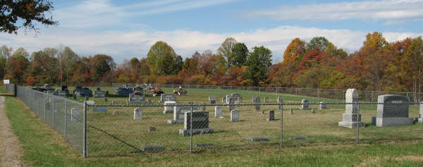
| Location | : | Knifley, Adair County, USA |
| Coordinate | : | 37.2477989, -85.0678024 |
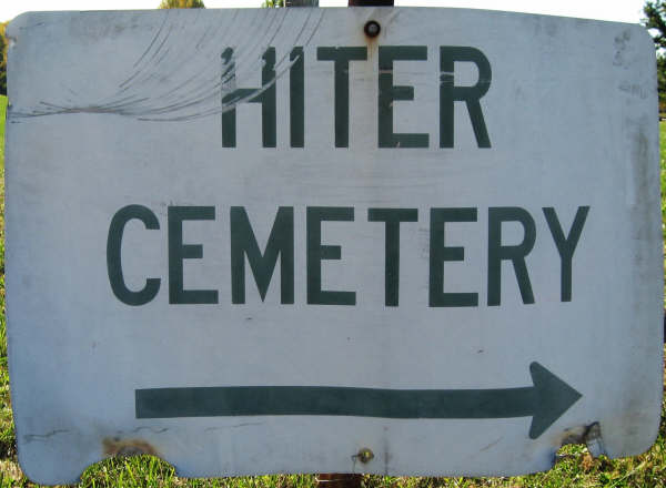
| Description | : | Turn left onto Moxey at Anioch Cem on the corner, passing Anioch on right. Cross Adair County Line. Soon after crossing the Adair County line you'll find the Hiter Cemetery sign on the right, along with the street sign. Turn right at the street sign and Hiter Cem sign on gravel road in-between two homes. I believe the street sign at the cemetery is Vannoy & Sanders Ridge. (Moxey turns into Sanders Ridge at some point.) The cemetery is only a few yards down the gravel road, (which looks like a driveway.) Hiter Cemetery is also in the middle of... Read More |
frequently asked questions (FAQ):
-
Where is Hiter Cemetery?
Hiter Cemetery is located at Knifley, Adair County ,Kentucky ,USA.
-
Hiter Cemetery cemetery's updated grave count on graveviews.com?
0 memorials
-
Where are the coordinates of the Hiter Cemetery?
Latitude: 37.2477989
Longitude: -85.0678024
Nearby Cemetories:
1. Mills Gravesite
Pellyton, Adair County, USA
Coordinate: 37.2424100, -85.0736100
2. Neel-Davis Cemetery #2
Creston, Casey County, USA
Coordinate: 37.2444440, -85.0486111
3. Antioch Baptist Church Cemetery
Casey County, USA
Coordinate: 37.2658600, -85.0492300
4. Pleasant Hill Cemetery
Barnett Springs, Adair County, USA
Coordinate: 37.2443160, -85.0970000
5. Barnett Creek Methodist Church Cemetery
Barnett Springs, Adair County, USA
Coordinate: 37.2304800, -85.0882500
6. Cold Springs Primitive Baptist Church Cemetery
Creston, Casey County, USA
Coordinate: 37.2681274, -85.0435638
7. Blessed Hope Old Regular Baptist Church Cemetery
Pellyton, Adair County, USA
Coordinate: 37.2145800, -85.0739200
8. Miller-Yoder Family Graveyard
Pellyton, Adair County, USA
Coordinate: 37.2141670, -85.0791670
9. Pellyton Cemetery
Pellyton, Adair County, USA
Coordinate: 37.2090900, -85.0783100
10. Pelley Slave Graveyard
Pellyton, Adair County, USA
Coordinate: 37.2093600, -85.0544900
11. Pelley-Gabhert Family Graveyard
Pellyton, Adair County, USA
Coordinate: 37.2083000, -85.0570000
12. Mount Pleasant Cemetery
Creston, Casey County, USA
Coordinate: 37.2750702, -85.0291214
13. Austin Cemetery
Casey County, USA
Coordinate: 37.2167015, -85.0306015
14. Kennett Cemetery
Casey County, USA
Coordinate: 37.2130360, -85.0354580
15. Fisher Cemetery
Casey County, USA
Coordinate: 37.2791750, -85.0296040
16. Saint Bernard Cemetery
Clementsville, Casey County, USA
Coordinate: 37.2877860, -85.0955300
17. Salem United Methodist Church Cemetery
Liberty, Casey County, USA
Coordinate: 37.2560320, -85.0109760
18. Saint Bernard Cemetery Old
Clementsville, Casey County, USA
Coordinate: 37.2892560, -85.0961550
19. Workman Cemetery
Neatsville, Adair County, USA
Coordinate: 37.2123870, -85.1094510
20. Pelley Cemetery
Pellyton, Adair County, USA
Coordinate: 37.1980200, -85.0826400
21. Luttrells Creek Cemetery
Dunnville, Casey County, USA
Coordinate: 37.1944427, -85.0532303
22. Rector Cemetery
Dunnville, Casey County, USA
Coordinate: 37.2130100, -85.0143000
23. Pelley-Rubarts Cemetery
Eunice, Adair County, USA
Coordinate: 37.1939970, -85.0511100
24. Caldwell Chapel Cemetery
Knifley, Adair County, USA
Coordinate: 37.2314800, -85.1395700