
| Memorials | : | 80 |
| Location | : | Bean Station, Grainger County, USA |
| Coordinate | : | 36.2775002, -83.3796997 |
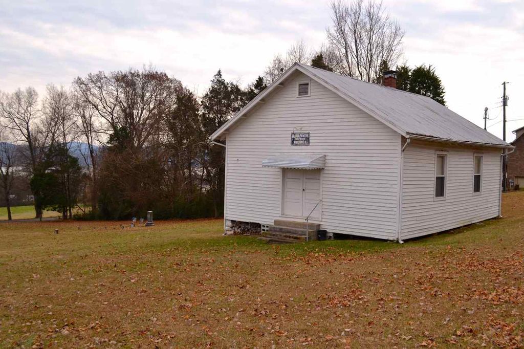
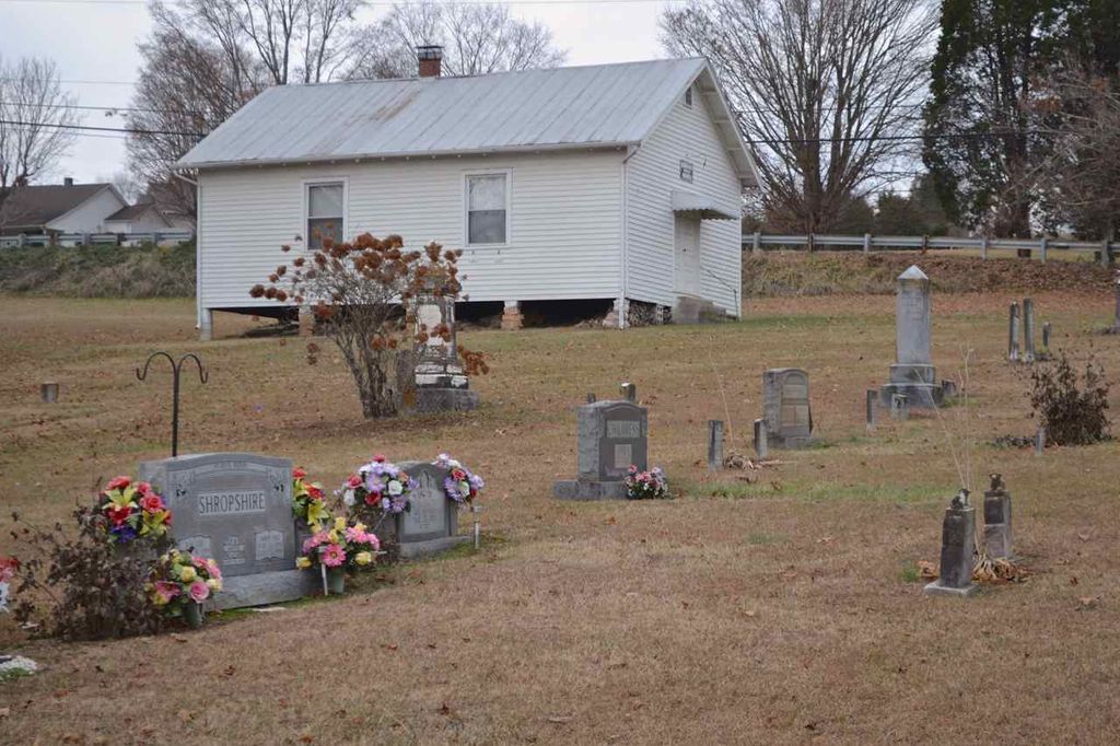
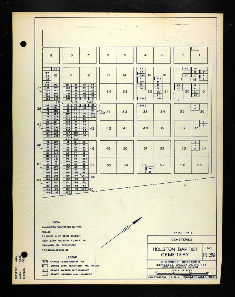
| Description | : | Holston Baptist Church Cemetery was originally located beside Holston Baptist Church, near the north shore of the Holston River, very close to the shoreline of the future Cherokee Lake. When TVA surveyed the cemetery prior to the creation of the lake in 1941, 43 graves were found and all were identified. The church relocated to its present location on Lakeshore Road, west of the original location, and a new cemetery was created beside it. Three of the graves in the original cemetery were removed to cemeteries in other counties, but the remaining forty graves were reinterred in the new relocated... Read More |
frequently asked questions (FAQ):
-
Where is Holston Baptist Church Cemetery?
Holston Baptist Church Cemetery is located at Twin Church Road Bean Station, Grainger County ,Tennessee ,USA.
-
Holston Baptist Church Cemetery cemetery's updated grave count on graveviews.com?
80 memorials
-
Where are the coordinates of the Holston Baptist Church Cemetery?
Latitude: 36.2775002
Longitude: -83.3796997
Nearby Cemetories:
1. Lakeshore Missionary Baptist Church Cemetery
Bean Station, Grainger County, USA
Coordinate: 36.2797470, -83.3780200
2. Freedom Chapel Missionary Baptist Church Cemetery
Grainger County, USA
Coordinate: 36.2865410, -83.3948480
3. Heath Chapel Cemetery
Grainger County, USA
Coordinate: 36.2851730, -83.3615220
4. Helton Cemetery
Bean Station, Grainger County, USA
Coordinate: 36.2910995, -83.3993988
5. Marys Chapel Cemetery
Grainger County, USA
Coordinate: 36.3011017, -83.3569031
6. Hodge Cemetery
Helton, Grainger County, USA
Coordinate: 36.2985360, -83.4077340
7. Holt's Baptist Church Cemetery
Morristown, Hamblen County, USA
Coordinate: 36.2467220, -83.3626160
8. Harrell Cemetery
Bean Station, Grainger County, USA
Coordinate: 36.3074989, -83.3463974
9. Macedonia Missionary Baptist Church Cemetery
Morristown, Hamblen County, USA
Coordinate: 36.2696100, -83.3301400
10. Kidwells Ridge Baptist Church Cemetery
Morristown, Hamblen County, USA
Coordinate: 36.2359870, -83.3917690
11. Cobb Cemetery
Grainger County, USA
Coordinate: 36.3189011, -83.3644028
12. Noeton Baptist Church Cemetery Original
Bean Station, Grainger County, USA
Coordinate: 36.3012600, -83.3342200
13. Harris Cemetery
Grainger County, USA
Coordinate: 36.3055992, -83.3308029
14. Bean Station Cemetery
Bean Station, Grainger County, USA
Coordinate: 36.3283000, -83.3697000
15. McBride Missionary Baptist Cemetery
Morristown, Hamblen County, USA
Coordinate: 36.2406500, -83.3348900
16. Bowen Cemetery
Grainger County, USA
Coordinate: 36.3093987, -83.4328003
17. Little Redeemed Church Cemetery
Hamblen County, USA
Coordinate: 36.2421700, -83.3291200
18. Winstead Family Cemetery
Hamblen County, USA
Coordinate: 36.2493060, -83.3161570
19. Buck Hollow Cemetery
Grainger County, USA
Coordinate: 36.3344120, -83.3589440
20. Ford Cemetery
Grainger County, USA
Coordinate: 36.2902985, -83.3071976
21. Grove Cemetery
Grainger County, USA
Coordinate: 36.2661018, -83.4558029
22. Floyd Cemetery
Grainger County, USA
Coordinate: 36.3328018, -83.4188995
23. Central Baptist Church Cemetery
Morristown, Hamblen County, USA
Coordinate: 36.2146200, -83.3558700
24. Noes Chapel United Methodist Church Cemetery
Morristown, Hamblen County, USA
Coordinate: 36.2401000, -83.3124900