
| Memorials | : | 4 |
| Location | : | Bean Station, Grainger County, USA |
| Coordinate | : | 36.3012600, -83.3342200 |
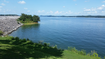
| Description | : | Now under the waters of Cherokee Lake, the original Noeton Baptist Church Cemetery was located behind the original church on the right bank of the Holston River at mile post 70. In 1940, this location was determined by TVA to be below the level of the future Cherokee Lake, forcing the relocation of the church, now known as Noeton Missionary Baptist Church, to its present location on Newman Hollow Road, and the creation of a new church cemetery across the road from the relocated church. The survey of the original cemetery showed 46 graves, but only sixteen of them were... Read More |
frequently asked questions (FAQ):
-
Where is Noeton Baptist Church Cemetery Original?
Noeton Baptist Church Cemetery Original is located at Bean Station, Grainger County ,Tennessee ,USA.
-
Noeton Baptist Church Cemetery Original cemetery's updated grave count on graveviews.com?
4 memorials
-
Where are the coordinates of the Noeton Baptist Church Cemetery Original?
Latitude: 36.3012600
Longitude: -83.3342200
Nearby Cemetories:
1. Harris Cemetery
Grainger County, USA
Coordinate: 36.3055992, -83.3308029
2. Harrell Cemetery
Bean Station, Grainger County, USA
Coordinate: 36.3074989, -83.3463974
3. Marys Chapel Cemetery
Grainger County, USA
Coordinate: 36.3011017, -83.3569031
4. Ford Cemetery
Grainger County, USA
Coordinate: 36.2902985, -83.3071976
5. Heath Chapel Cemetery
Grainger County, USA
Coordinate: 36.2851730, -83.3615220
6. Cobb Cemetery
Grainger County, USA
Coordinate: 36.3189011, -83.3644028
7. Macedonia Missionary Baptist Church Cemetery
Morristown, Hamblen County, USA
Coordinate: 36.2696100, -83.3301400
8. Samsel Cemetery
Bean Station, Grainger County, USA
Coordinate: 36.3114014, -83.2925034
9. Taylor Family Cemetery
Bean Station, Grainger County, USA
Coordinate: 36.2876670, -83.2907330
10. Adriel Baptist Church Cemetery
Bean Station, Grainger County, USA
Coordinate: 36.3125000, -83.2897034
11. Dodson Cemetery
Bean Station, Grainger County, USA
Coordinate: 36.2989006, -83.2869034
12. Buck Hollow Cemetery
Grainger County, USA
Coordinate: 36.3344120, -83.3589440
13. Bean Station Cemetery
Bean Station, Grainger County, USA
Coordinate: 36.3283000, -83.3697000
14. Lakeshore Missionary Baptist Church Cemetery
Bean Station, Grainger County, USA
Coordinate: 36.2797470, -83.3780200
15. Dalton Cemetery
Bean Station, Grainger County, USA
Coordinate: 36.3428001, -83.3296967
16. First Independent Freewill Baptist Church Cemetery
Bean Station, Grainger County, USA
Coordinate: 36.3158860, -83.2855850
17. Samsel Cemetery
Bean Station, Grainger County, USA
Coordinate: 36.3424020, -83.3167060
18. Holston Baptist Church Cemetery
Bean Station, Grainger County, USA
Coordinate: 36.2775002, -83.3796997
19. Rocky Summit Cemetery
Bean Station, Grainger County, USA
Coordinate: 36.2984750, -83.2799030
20. Grantham Cemetery
Grainger County, USA
Coordinate: 36.2946860, -83.2794570
21. Garrett Cemetery
Grainger County, USA
Coordinate: 36.3414001, -83.3082962
22. Samsel Lakeview Cemetery
Bean Station, Grainger County, USA
Coordinate: 36.3475800, -83.3189468
23. Meek Cemetery
Bean Station, Grainger County, USA
Coordinate: 36.3207180, -83.2797150
24. County Line Cemetery
Bean Station, Grainger County, USA
Coordinate: 36.3207700, -83.2789850