
| Memorials | : | 1 |
| Location | : | Fergus, Wellington County, Canada |
| Coordinate | : | 43.6905910, -80.3943440 |
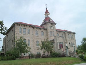
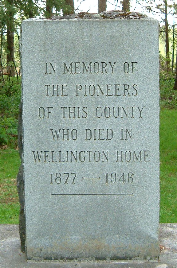
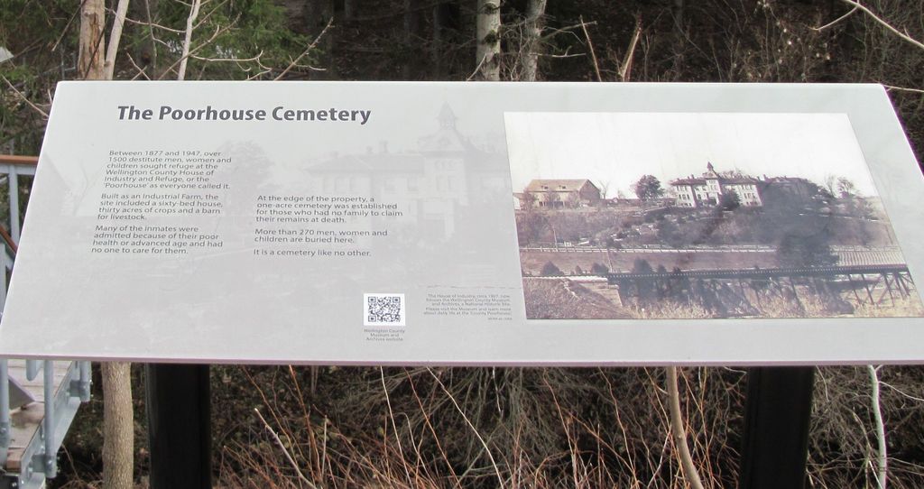
| Description | : | As the name suggests, this burial ground is the last resting place of many former residents of the House of Industry and Refuge. In more recent times this property was known as the Wellington County Home for the Aged, and most recently, The Wellington County Museum & Archives. Wilfred E. Roszell, who served as Superintendent of that establishment for a lengthy period, is authority for the information that the first interment took place in the month of December, 1877, and that the cemetery was closed to further burials in 1946. During that period of 69 years a total of 266 interments were... Read More |
frequently asked questions (FAQ):
-
Where is House of Industry & Refuge Cemetery?
House of Industry & Refuge Cemetery is located at 0536 Wellington County Road 18, RR#1 Fergus, Wellington County ,Ontario , N1M 2W3Canada.
-
House of Industry & Refuge Cemetery cemetery's updated grave count on graveviews.com?
1 memorials
-
Where are the coordinates of the House of Industry & Refuge Cemetery?
Latitude: 43.6905910
Longitude: -80.3943440
Nearby Cemetories:
1. Wellington County Cemetery
Elora, Wellington County, Canada
Coordinate: 43.6913500, -80.3954600
2. Saint Joseph's Catholic Cemetery
Fergus, Wellington County, Canada
Coordinate: 43.7024918, -80.3827591
3. Saint Andrews Auld Presbyterian Kirkyard
Fergus, Wellington County, Canada
Coordinate: 43.7042122, -80.3811722
4. Belsyde Cemetery
Fergus, Wellington County, Canada
Coordinate: 43.7063522, -80.3686829
5. Saint John the Evangelist Anglican Cairn
Elora, Wellington County, Canada
Coordinate: 43.6756940, -80.4300500
6. Elora Cemetery
Elora, Wellington County, Canada
Coordinate: 43.6876259, -80.4413986
7. St. Mary's Roman Catholic Cemetery
Elora, Wellington County, Canada
Coordinate: 43.6868510, -80.4414870
8. Mount Pleasant Cemetery
Centre Wellington Township, Wellington County, Canada
Coordinate: 43.6436000, -80.3141000
9. Bethel Mennonite Cemetery
Elora, Wellington County, Canada
Coordinate: 43.6720009, -80.5111160
10. Bloomsbury Methodist Cemetery
Centre Wellington Township, Wellington County, Canada
Coordinate: 43.7020810, -80.5405760
11. Maple View Mennonite Cemetery
Alma, Wellington County, Canada
Coordinate: 43.7482990, -80.5179980
12. Calvary Conservative Mennonite Cemetery
Woolwich Township, Waterloo Regional Municipality, Canada
Coordinate: 43.6695709, -80.5437622
13. Johnson-Eramosa Union Cemetery
Eramosa Township, Wellington County, Canada
Coordinate: 43.6515600, -80.2516100
14. Mount Carmel Cemetery
Belwood, Wellington County, Canada
Coordinate: 43.7967320, -80.3501690
15. Sandhills Baptist Cemetery
Woolwich Township, Waterloo Regional Municipality, Canada
Coordinate: 43.6476440, -80.5368670
16. West Montrose Mennonite Meeting House Cemetery
West Montrose, Waterloo Regional Municipality, Canada
Coordinate: 43.5967293, -80.4791183
17. West Montrose United Church Cemetery
West Montrose, Waterloo Regional Municipality, Canada
Coordinate: 43.5900917, -80.4815063
18. Creek Bank Mennonite Cemetery
Creek Bank, Wellington County, Canada
Coordinate: 43.6863861, -80.5634460
19. McKee Cemetery
Craigsholme, Dufferin County, Canada
Coordinate: 43.7811600, -80.2775700
20. McCormick Cemetery
Eramosa Township, Wellington County, Canada
Coordinate: 43.6347500, -80.2403300
21. Saint Pauls Evangelical Lutheran Cemetery
Waterloo Regional Municipality, Canada
Coordinate: 43.5935360, -80.5088050
22. Winterbourne Mennonite Cemetery
Winterbourne, Waterloo Regional Municipality, Canada
Coordinate: 43.5704422, -80.4729614
23. North Woolwich Mennonite Meeting House Cemetery
Floradale, Waterloo Regional Municipality, Canada
Coordinate: 43.6510315, -80.5748901
24. Mimosa Union Cemetery
Mimosa, Wellington County, Canada
Coordinate: 43.7456690, -80.2202533