
| Memorials | : | 0 |
| Location | : | Murray County, USA |
| Coordinate | : | 34.4601800, -97.1174670 |
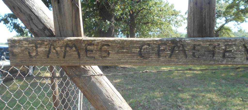
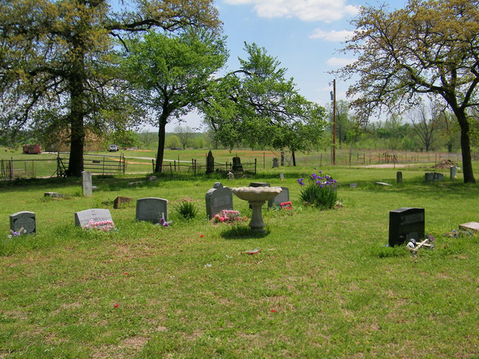
| Description | : | James Cemetery is an old African American cemetery located 2 miles south and 1/2 mile east of Davis, Murray County, Oklahoma. The cemetery is located on property owner by descendants of the James family. The James family does not mind persons entering the property to view the cemetery without prior permission. The cemetery is in fair condition but is overgrown with grass and weeds, depending on the time of year. The oldest marker found was dated 1886. One interesting headstone in the cemetery is that of Richmond Kimble who was a PVT Buffalo Soldier 10th U.S. Cavalry Tennessee. There is a large... Read More |
frequently asked questions (FAQ):
-
Where is James Cemetery?
James Cemetery is located at Knapp Road Murray County ,Oklahoma , 73039USA.
-
James Cemetery cemetery's updated grave count on graveviews.com?
0 memorials
-
Where are the coordinates of the James Cemetery?
Latitude: 34.4601800
Longitude: -97.1174670

Nearby Cemetories:
1. Walnut Cemetery
Davis, Murray County, USA
Coordinate: 34.4427780, -97.0852780
2. Price Chapel Cemetery
Davis, Murray County, USA
Coordinate: 34.4322014, -97.0958023
3. Green Hill Cemetery
Davis, Murray County, USA
Coordinate: 34.4981003, -97.1294022
4. Oak Ridge Cemetery
Davis, Murray County, USA
Coordinate: 34.5050011, -97.1296997
5. Howell Cemetery
Garvin County, USA
Coordinate: 34.5080986, -97.1735992
6. Oak Ridge Cemetery
Garvin County, USA
Coordinate: 34.5127983, -97.1921997
7. Dougherty Cemetery
Dougherty, Murray County, USA
Coordinate: 34.3993200, -97.0425000
8. Wheeler Flats Cemetery
Murray County, USA
Coordinate: 34.5614014, -97.1399994
9. Sandy Baptist Church Cemetery
Sulphur, Murray County, USA
Coordinate: 34.5483500, -97.0284700
10. Cobb Cemetery
Springer, Carter County, USA
Coordinate: 34.3445560, -97.1648810
11. Fort Arbuckle Cemetery
Washita, Murray County, USA
Coordinate: 34.5208330, -97.2472220
12. Big Canyon Cemetery
Murray County, USA
Coordinate: 34.3630981, -97.0255966
13. Wynnewood View Cemetery
Garvin County, USA
Coordinate: 34.5787930, -97.1955940
14. Buckhorn Cemetery
Sulphur, Murray County, USA
Coordinate: 34.4622002, -96.9511032
15. Drake-Nebo Cemetery
Drake, Murray County, USA
Coordinate: 34.3897018, -96.9728012
16. Oaklawn Cemetery
Leeper Township, Murray County, USA
Coordinate: 34.5469017, -96.9822006
17. Lowrance Cemetery
Murray County, USA
Coordinate: 34.4602400, -96.9448800
18. William Taylor Grave
Sulphur, Murray County, USA
Coordinate: 34.4230560, -96.9502780
19. Springer Cemetery
Springer, Carter County, USA
Coordinate: 34.3129700, -97.1367000
20. Calvary Cemetery
Gene Autry, Carter County, USA
Coordinate: 34.3213150, -97.0451350
21. Shirley Family Cemetery
Murray County, USA
Coordinate: 34.5410520, -96.9600990
22. Ramer Cemetery
Sulphur, Murray County, USA
Coordinate: 34.5438890, -96.9563890
23. Old Five Mile Cemetery
Murray County, USA
Coordinate: 34.5005560, -97.3077780
24. Glenn Cemetery
Glenn, Carter County, USA
Coordinate: 34.3067500, -97.1961000