
| Memorials | : | 0 |
| Location | : | Steinhart, Landkreis Donau-Ries, Germany |
| Coordinate | : | 48.9600246, 10.6754638 |
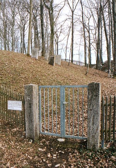
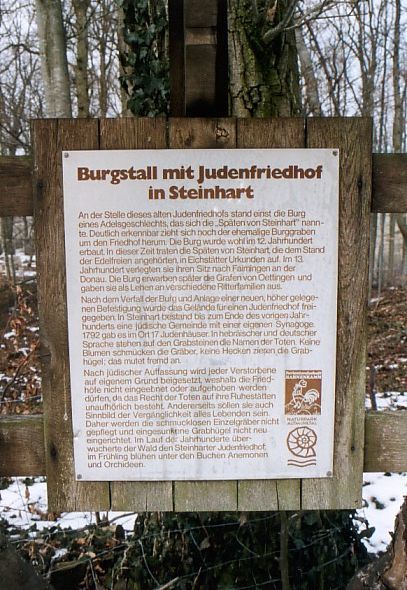
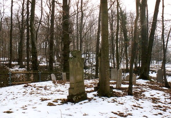
| Description | : | The Jewish Cemetery in Steinhart was created in the 18th Century. It is located 50 m directly below the mighty castle ruins on the site of a previous castle built in 1328, so the cemetery is also surrounded by an old moat. This old castle originally belonged to the noble family of the "Late von Steinhart". The old castle hill with the cemetery is called "Judenbuck". The cemetery (area: 1430 square meters) is surrounded by a wooden fence, which is interrupted by a small metal door. Only 99 of the formerly existing tombstones have survived. The... Read More |
frequently asked questions (FAQ):
-
Where is Jewish Cemetery of Steinhart?
Jewish Cemetery of Steinhart is located at Steinhart, Landkreis Donau-Ries ,Bavaria (Bayern) ,Germany.
-
Jewish Cemetery of Steinhart cemetery's updated grave count on graveviews.com?
0 memorials
-
Where are the coordinates of the Jewish Cemetery of Steinhart?
Latitude: 48.9600246
Longitude: 10.6754638

Nearby Cemetories:
1. Benediktinerkloster in Markt Heidenheim
Heidenheim, Landkreis Weißenburg-Gunzenhausen, Germany
Coordinate: 49.0167000, 10.7500000
2. Friedhof Wolferstadt
Wolferstadt, Landkreis Donau-Ries, Germany
Coordinate: 48.9010850, 10.7754440
3. Kloster Zimmern
Deiningen, Landkreis Donau-Ries, Germany
Coordinate: 48.8762000, 10.5569000
4. Pflaumfeld
Gunzenhausen, Landkreis Weißenburg-Gunzenhausen, Germany
Coordinate: 49.0771900, 10.7386290
5. Klosterkirche Maria Immaculata
Maihingen, Landkreis Donau-Ries, Germany
Coordinate: 48.9284000, 10.4914600
6. Jüdischer Friedhof Wallerstein
Wallerstein, Landkreis Donau-Ries, Germany
Coordinate: 48.8892170, 10.4920120
7. Friedhof Aha
Aha, Landkreis Weißenburg-Gunzenhausen, Germany
Coordinate: 49.0974246, 10.7514500
8. Laurentiuskirche
Rehlingen, Landkreis Weißenburg-Gunzenhausen, Germany
Coordinate: 48.9150610, 10.8879280
9. St. Jodokus-Kirche, Enkingen.
Enkingen, Landkreis Donau-Ries, Germany
Coordinate: 48.8266170, 10.5738487
10. Dornhausen Cemetery
Dornhausen, Landkreis Weißenburg-Gunzenhausen, Germany
Coordinate: 49.0879050, 10.8199320
11. St.-Georgs-Kirche
Nördlingen, Landkreis Donau-Ries, Germany
Coordinate: 48.8506700, 10.4884200
12. Jewish Cemetery of Gunzenhausen
Gunzenhausen, Landkreis Weißenburg-Gunzenhausen, Germany
Coordinate: 49.1140213, 10.7653408
13. Friedhof Nördlingen
Nördlingen, Landkreis Donau-Ries, Germany
Coordinate: 48.8461070, 10.4809419
14. Jüdischer Friedhof Nördlingen
Nördlingen, Landkreis Donau-Ries, Germany
Coordinate: 48.8482300, 10.4777300
15. St. Michael Obermichelbach
Obermichelbach, Landkreis Ansbach, Germany
Coordinate: 49.0601483, 10.4351895
16. Jüdischer Friedhof Pflaumloch
Pflaumloch, Ostalbkreis, Germany
Coordinate: 48.8507600, 10.4308700
17. Friedhof Dorfkemmathen
Dorfkemmathen, Landkreis Ansbach, Germany
Coordinate: 49.0835504, 10.4432640
18. Jüdischer Friedhof Mönchsdeggingen
Mönchsdeggingen, Landkreis Donau-Ries, Germany
Coordinate: 48.7713200, 10.5761000
19. Weißenburg Neuer Friedhof
Weissenburg in Bayern, Landkreis Weißenburg-Gunzenhausen, Germany
Coordinate: 49.0360600, 10.9577470
20. Pfarrkirche Mariä Himmelfahrt
Kirchheim am Ries, Ostalbkreis, Germany
Coordinate: 48.8768800, 10.3975200
21. Friedhof Unterschneidheim
Unterschneidheim, Ostalbkreis, Germany
Coordinate: 48.9395140, 10.3687660
22. Weißenburg Alter Friedhof
Weissenburg in Bayern, Landkreis Weißenburg-Gunzenhausen, Germany
Coordinate: 49.0280340, 10.9671340
23. Kloster Kaisheim
Alerheim, Landkreis Donau-Ries, Germany
Coordinate: 48.7672220, 10.7983330
24. Friedhof Gräfensteinberg
Grafensteinberg, Landkreis Weißenburg-Gunzenhausen, Germany
Coordinate: 49.1511578, 10.8102554