
| Memorials | : | 0 |
| Location | : | Gunzenhausen, Landkreis Weißenburg-Gunzenhausen, Germany |
| Coordinate | : | 49.1140213, 10.7653408 |
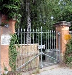
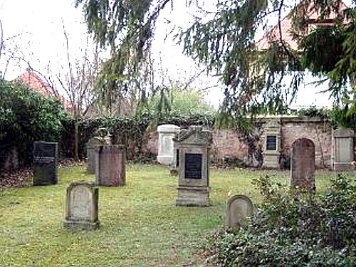
| Description | : | This small Jewish cemetery can be found in the Leonhardsruhstraße behind a stone wall in the middle of Gunzenhausen (Mittelfranken), a small town in Northern Bavaria. It's only 3271 square meters (about 0.8 acres) in size. Founded in 1875 for the tiny Jewish community in Gunzenhausen it saw about 500 funerals over the next 60 years. It was heavily damaged and looted during the Nazi progroms of the 1930's. The grave yard is now dormant. After World War II some restaurations have been taken place, but only a few grave stones remain and nature is slowly taking over. |
frequently asked questions (FAQ):
-
Where is Jewish Cemetery of Gunzenhausen?
Jewish Cemetery of Gunzenhausen is located at Gunzenhausen, Landkreis Weißenburg-Gunzenhausen ,Bavaria (Bayern) ,Germany.
-
Jewish Cemetery of Gunzenhausen cemetery's updated grave count on graveviews.com?
0 memorials
-
Where are the coordinates of the Jewish Cemetery of Gunzenhausen?
Latitude: 49.1140213
Longitude: 10.7653408
Nearby Cemetories:
1. Friedhof Aha
Aha, Landkreis Weißenburg-Gunzenhausen, Germany
Coordinate: 49.0974246, 10.7514500
2. Pflaumfeld
Gunzenhausen, Landkreis Weißenburg-Gunzenhausen, Germany
Coordinate: 49.0771900, 10.7386290
3. Dornhausen Cemetery
Dornhausen, Landkreis Weißenburg-Gunzenhausen, Germany
Coordinate: 49.0879050, 10.8199320
4. Friedhof Gräfensteinberg
Grafensteinberg, Landkreis Weißenburg-Gunzenhausen, Germany
Coordinate: 49.1511578, 10.8102554
5. Friedhof Hirschlach
Hirschlach, Landkreis Ansbach, Germany
Coordinate: 49.1797790, 10.6768865
6. Benediktinerkloster in Markt Heidenheim
Heidenheim, Landkreis Weißenburg-Gunzenhausen, Germany
Coordinate: 49.0167000, 10.7500000
7. Friedhof Merkendorf
Merkendorf, Landkreis Ansbach, Germany
Coordinate: 49.2060342, 10.7011449
8. Friedhof Spalt
Spalt, Landkreis Roth, Germany
Coordinate: 49.1791817, 10.9256435
9. Friedhof Ellingen
Ellingen, Landkreis Weißenburg-Gunzenhausen, Germany
Coordinate: 49.0576130, 10.9691650
10. Weißenburg Neuer Friedhof
Weissenburg in Bayern, Landkreis Weißenburg-Gunzenhausen, Germany
Coordinate: 49.0360600, 10.9577470
11. Weißenburg Alter Friedhof
Weissenburg in Bayern, Landkreis Weißenburg-Gunzenhausen, Germany
Coordinate: 49.0280340, 10.9671340
12. Catholic Cemetery
Burgoberbach, Landkreis Ansbach, Germany
Coordinate: 49.2351480, 10.5978580
13. Friedhof Immeldorf
Immeldorf, Landkreis Ansbach, Germany
Coordinate: 49.2761630, 10.7237590
14. Jewish Cemetery of Steinhart
Steinhart, Landkreis Donau-Ries, Germany
Coordinate: 48.9600246, 10.6754638
15. Friedhof Lichtenau
Lichtenau, Landkreis Ansbach, Germany
Coordinate: 49.2755090, 10.6843460
16. Friedhof Lichtenau bei Ansbach
Lichtenau, Landkreis Ansbach, Germany
Coordinate: 49.2760440, 10.6847240
17. Dorffriedhof
Neuendettelsau, Landkreis Ansbach, Germany
Coordinate: 49.2845700, 10.7928000
18. Friedhof Diakonie Neuendettelsau
Neuendettelsau, Landkreis Ansbach, Germany
Coordinate: 49.2895900, 10.7808150
19. Friedhof Georgensgmünd
Georgensgmund, Landkreis Roth, Germany
Coordinate: 49.1878500, 11.0113370
20. Friedhofskirche St. Ulrich
Röttenbach, Landkreis Roth, Germany
Coordinate: 49.1516760, 11.0354160
21. Friedhof Wülzburg
Weissenburg in Bayern, Landkreis Weißenburg-Gunzenhausen, Germany
Coordinate: 49.0243480, 11.0103290
22. Friedhof Bertholdsdorf
Bertholdsdorf, Landkreis Ansbach, Germany
Coordinate: 49.2895137, 10.8736590
23. Friedhof Wieseth
Wieseth, Landkreis Ansbach, Germany
Coordinate: 49.1613807, 10.4794709
24. Saint Martin's Church
Oberhochstatt, Landkreis Weißenburg-Gunzenhausen, Germany
Coordinate: 49.0330600, 11.0422900