
| Memorials | : | 0 |
| Location | : | Clarksville, Montgomery County, USA |
| Coordinate | : | 36.5053180, -87.3614680 |
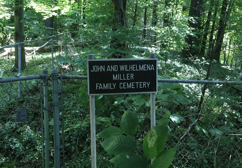
| Description | : | This very small cemetery is located in Clarksville, Montgomery County, Tennessee on Ashland City Road, southeast of the intersection of that road and Cumberland Drive. GPS coordinates are 36.505318, -87.361468. Driving southeast, after passing Gary Mathews Motors, AutoZone, and Stor-alot Self Storage (1170 Ashland City Rd), the cemetery is on the edge of the woods, at the top of a hill barely 50 feet from the road. The cemetery is surrounded by a chain link fence and is marked with a sign. Due to dense growth, it is not visible from the road during spring and summer, but... Read More |
frequently asked questions (FAQ):
-
Where is John and Wilhelmena Miller Family Cemetery?
John and Wilhelmena Miller Family Cemetery is located at Clarksville, Montgomery County ,Tennessee ,USA.
-
John and Wilhelmena Miller Family Cemetery cemetery's updated grave count on graveviews.com?
0 memorials
-
Where are the coordinates of the John and Wilhelmena Miller Family Cemetery?
Latitude: 36.5053180
Longitude: -87.3614680
Nearby Cemetories:
1. Mount Olive Cemetery
Clarksville, Montgomery County, USA
Coordinate: 36.5107460, -87.3522305
2. Greenwood Cemetery
Clarksville, Montgomery County, USA
Coordinate: 36.5069008, -87.3422012
3. Evergreen Cemetery
Clarksville, Montgomery County, USA
Coordinate: 36.5031013, -87.3422012
4. Golden Hill Cemetery
Clarksville, Montgomery County, USA
Coordinate: 36.5032616, -87.3415527
5. Gum Springs Baptist Church Cemetery
Montgomery County, USA
Coordinate: 36.4954796, -87.3815384
6. Mount Pisgah Cemetery
Cumberland Heights, Montgomery County, USA
Coordinate: 36.5064380, -87.3891760
7. Edgefield Missionary Baptist Church Cemetery
Clarksville, Montgomery County, USA
Coordinate: 36.5100800, -87.3281800
8. Foston Memorial Gardens
Clarksville, Montgomery County, USA
Coordinate: 36.5106820, -87.3281200
9. Macedonia Cemetery
Clarksville, Montgomery County, USA
Coordinate: 36.5040190, -87.3960360
10. Alex Yarbrough Cemetery
Cumberland Heights, Montgomery County, USA
Coordinate: 36.5039650, -87.3964180
11. All Saints Columbarium
Clarksville, Montgomery County, USA
Coordinate: 36.4748210, -87.3411140
12. Peacher Family Cemetery
Clarksville, Montgomery County, USA
Coordinate: 36.5112720, -87.3175420
13. Lyle Cemetery
Montgomery County, USA
Coordinate: 36.4706001, -87.3386002
14. Dunlop Gold Cemetery
Montgomery County, USA
Coordinate: 36.5438730, -87.3233410
15. Keesee Cemetery
Montgomery County, USA
Coordinate: 36.4658012, -87.3989029
16. Kizzee Cemetery
Montgomery County, USA
Coordinate: 36.4651270, -87.3987720
17. Mount Lebanon Cemetery
Clarksville, Montgomery County, USA
Coordinate: 36.4560780, -87.3817050
18. Memorial Baptist Church Cemetery
Clarksville, Montgomery County, USA
Coordinate: 36.4519800, -87.3754560
19. Lofland Cemetery
Clarksville, Montgomery County, USA
Coordinate: 36.5410423, -87.3093147
20. Martin Chapel Cemetery
Cumberland Heights, Montgomery County, USA
Coordinate: 36.4647060, -87.4181140
21. Hiter Cemetery
Montgomery County, USA
Coordinate: 36.4588450, -87.4174400
22. Antioch Methodist Church Cemetery
Clarksville, Montgomery County, USA
Coordinate: 36.4487610, -87.4005966
23. Mount Pleasant United Methodist Church Cemetery
Montgomery County, USA
Coordinate: 36.5064000, -87.4508000
24. Kenwood Baptist Church Cemetery
Kenwood, Montgomery County, USA
Coordinate: 36.5752820, -87.3895140