
| Memorials | : | 0 |
| Location | : | Port Edwards, Wood County, USA |
| Coordinate | : | 44.3499985, -89.8556366 |
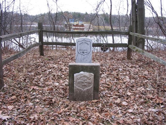
| Description | : | Civil War Grave - Jones Burial Township of Port Edwards Wood County, Wisconsin In Port Edwards; along the west bank of the Wisconsin River, upriver from the nearby dam. Near the intersection of State Highway 54 & 73 (Wisconsin River Drive), and Ver Bunker Avenue. Not a cemetery. The only grave located here has been entered. |
frequently asked questions (FAQ):
-
Where is John Jones Burial Site?
John Jones Burial Site is located at Port Edwards, Wood County ,Wisconsin ,USA.
-
John Jones Burial Site cemetery's updated grave count on graveviews.com?
0 memorials
-
Where are the coordinates of the John Jones Burial Site?
Latitude: 44.3499985
Longitude: -89.8556366
Nearby Cemetories:
1. Wood County Cemetery
Wisconsin Rapids, Wood County, USA
Coordinate: 44.3660100, -89.8744600
2. Port Edwards Municipal Cemetery
Port Edwards, Wood County, USA
Coordinate: 44.3430023, -89.8971786
3. Riverside Cemetery
Nekoosa, Wood County, USA
Coordinate: 44.3303261, -89.8910370
4. Saint John Episcopal Church
Wisconsin Rapids, Wood County, USA
Coordinate: 44.3904780, -89.8235940
5. Forest Hill Cemetery
Wisconsin Rapids, Wood County, USA
Coordinate: 44.4006004, -89.8039017
6. Calvary Cemetery
Wisconsin Rapids, Wood County, USA
Coordinate: 44.4030991, -89.7994003
7. Pioneer Cemetery
Wisconsin Rapids, Wood County, USA
Coordinate: 44.3367004, -89.7639008
8. Waub-Mee-Mee Cemetery
Seneca, Wood County, USA
Coordinate: 44.4051600, -89.9212100
9. White Indian Cemetery
Seneca, Wood County, USA
Coordinate: 44.4061000, -89.9479000
10. Green Hill Cemetery
Nekoosa, Wood County, USA
Coordinate: 44.2606010, -89.8713989
11. Saint Johns Cemetery
Rudolph, Wood County, USA
Coordinate: 44.4357986, -89.7968979
12. Saint John Lutheran Cemetery
Wisconsin Rapids, Wood County, USA
Coordinate: 44.4453011, -89.8933029
13. Saint Johns Lutheran Parish Cemetery
Kellner, Portage County, USA
Coordinate: 44.3630981, -89.7138977
14. Restlawn Memorial Park
Wisconsin Rapids, Wood County, USA
Coordinate: 44.4199638, -89.7460022
15. First English Lutheran Cemetery
Wisconsin Rapids, Wood County, USA
Coordinate: 44.4635582, -89.8542557
16. Saint Josephs Catholic Cemetery
Vesper, Wood County, USA
Coordinate: 44.4172440, -89.9886932
17. Griesbach Cemetery
Vesper, Wood County, USA
Coordinate: 44.4450645, -89.9543304
18. Greenwood Cemetery
New Miner, Juneau County, USA
Coordinate: 44.2386017, -89.9131012
19. Saint Pauls Lutheran Cemetery
Vesper, Wood County, USA
Coordinate: 44.4424210, -89.9630051
20. Holy Rosary Cemetery
Wisconsin Rapids, Wood County, USA
Coordinate: 44.4706001, -89.8683014
21. Spring Branch Cemetery
New Rome, Adams County, USA
Coordinate: 44.2219009, -89.7774963
22. Saint Philip Catholic Cemetery
Rudolph, Wood County, USA
Coordinate: 44.4886017, -89.8285980
23. Bethany Lutheran Cemetery
Wisconsin Rapids, Wood County, USA
Coordinate: 44.4961900, -89.8842920
24. All Souls Cemetery
Rudolph, Wood County, USA
Coordinate: 44.5005074, -89.8009186