
| Memorials | : | 0 |
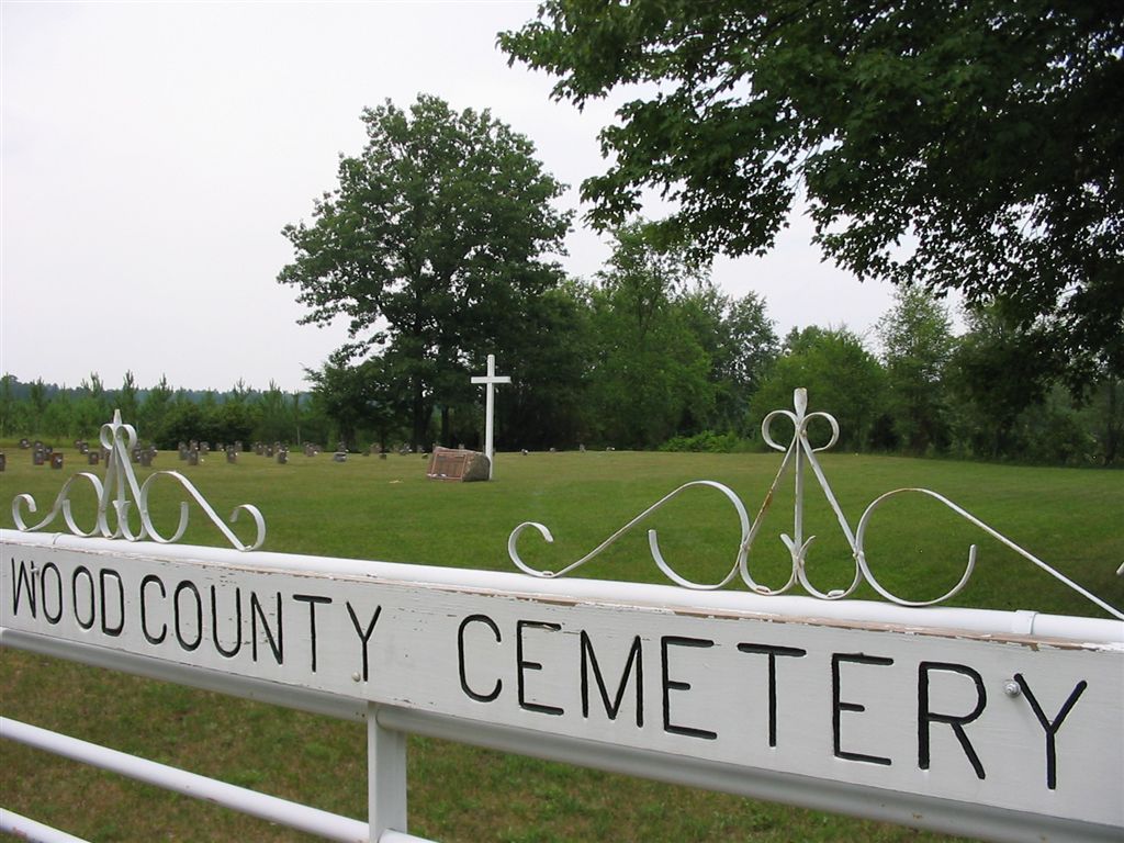
| Location | : | Wisconsin Rapids, Wood County, USA |
| Coordinate | : | 44.3660100, -89.8744600 |
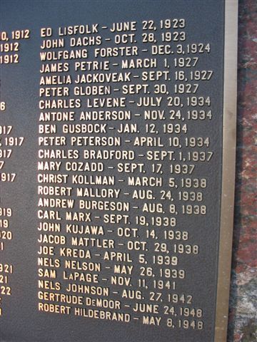
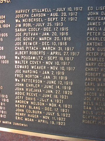
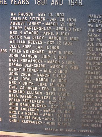
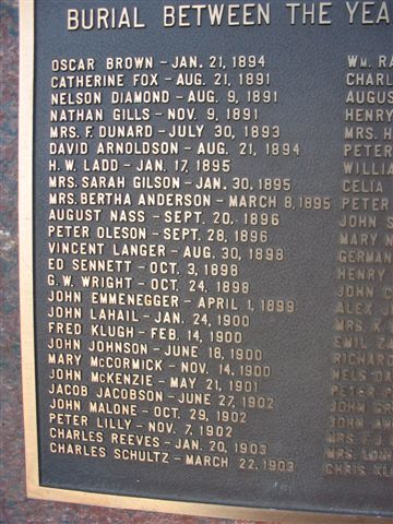
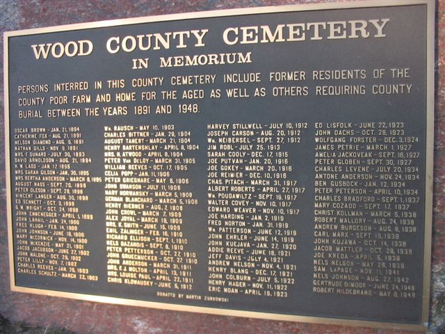
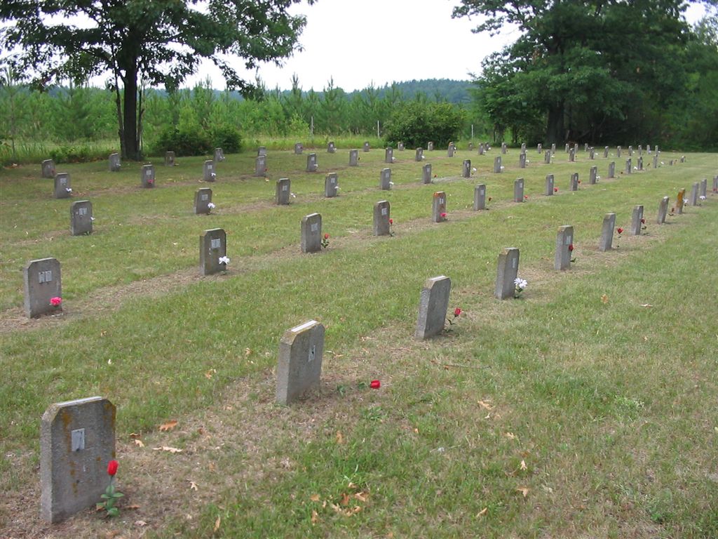
| Description | : | Wood County Cemetery/ Wood County Poor Farm Cemetery Township of Seneca; between Port Edwards and Wisconsin Rapids. Located on the north side of Seneca Road, 0.6 miles west of State Highways 54 and 73. Persons interred in this county cemetery include former residents of the county poor farm* and home for the aged** as well as others requiring county burial until 1948 when it was abandoned. *1884 - Poor Farm (located along Seneca Rd.) **1928 - Wood County Home for the Aged (located along Wis. River Dr.) 1952 - (renamed) Wood County Infirmary 1967 - (renamed) Edgewater Haven The cemetery... Read More |
frequently asked questions (FAQ):
-
Where is Wood County Cemetery?
Wood County Cemetery is located at Seneca Road Wisconsin Rapids, Wood County ,Wisconsin , 54495USA.
-
Wood County Cemetery cemetery's updated grave count on graveviews.com?
0 memorials
-
Where are the coordinates of the Wood County Cemetery?
Latitude: 44.3660100
Longitude: -89.8744600
Nearby Cemetories:
1. John Jones Burial Site
Port Edwards, Wood County, USA
Coordinate: 44.3499985, -89.8556366
2. Port Edwards Municipal Cemetery
Port Edwards, Wood County, USA
Coordinate: 44.3430023, -89.8971786
3. Riverside Cemetery
Nekoosa, Wood County, USA
Coordinate: 44.3303261, -89.8910370
4. Saint John Episcopal Church
Wisconsin Rapids, Wood County, USA
Coordinate: 44.3904780, -89.8235940
5. Waub-Mee-Mee Cemetery
Seneca, Wood County, USA
Coordinate: 44.4051600, -89.9212100
6. Forest Hill Cemetery
Wisconsin Rapids, Wood County, USA
Coordinate: 44.4006004, -89.8039017
7. Calvary Cemetery
Wisconsin Rapids, Wood County, USA
Coordinate: 44.4030991, -89.7994003
8. White Indian Cemetery
Seneca, Wood County, USA
Coordinate: 44.4061000, -89.9479000
9. Saint John Lutheran Cemetery
Wisconsin Rapids, Wood County, USA
Coordinate: 44.4453011, -89.8933029
10. Pioneer Cemetery
Wisconsin Rapids, Wood County, USA
Coordinate: 44.3367004, -89.7639008
11. Saint Johns Cemetery
Rudolph, Wood County, USA
Coordinate: 44.4357986, -89.7968979
12. Saint Josephs Catholic Cemetery
Vesper, Wood County, USA
Coordinate: 44.4172440, -89.9886932
13. Griesbach Cemetery
Vesper, Wood County, USA
Coordinate: 44.4450645, -89.9543304
14. First English Lutheran Cemetery
Wisconsin Rapids, Wood County, USA
Coordinate: 44.4635582, -89.8542557
15. Saint Pauls Lutheran Cemetery
Vesper, Wood County, USA
Coordinate: 44.4424210, -89.9630051
16. Holy Rosary Cemetery
Wisconsin Rapids, Wood County, USA
Coordinate: 44.4706001, -89.8683014
17. Green Hill Cemetery
Nekoosa, Wood County, USA
Coordinate: 44.2606010, -89.8713989
18. Restlawn Memorial Park
Wisconsin Rapids, Wood County, USA
Coordinate: 44.4199638, -89.7460022
19. Saint Johns Lutheran Parish Cemetery
Kellner, Portage County, USA
Coordinate: 44.3630981, -89.7138977
20. Saint Philip Catholic Cemetery
Rudolph, Wood County, USA
Coordinate: 44.4886017, -89.8285980
21. Bethany Lutheran Cemetery
Wisconsin Rapids, Wood County, USA
Coordinate: 44.4961900, -89.8842920
22. Greenwood Cemetery
New Miner, Juneau County, USA
Coordinate: 44.2386017, -89.9131012
23. Faith Reformed Church Cemetery
Vesper, Wood County, USA
Coordinate: 44.4823570, -89.9764820
24. Saint James Cemetery
Vesper, Wood County, USA
Coordinate: 44.4880981, -89.9794006