
| Memorials | : | 0 |
| Location | : | Karlsruhe, Stadtkreis Karlsruhe, Germany |
| Coordinate | : | 49.0092200, 8.4039400 |
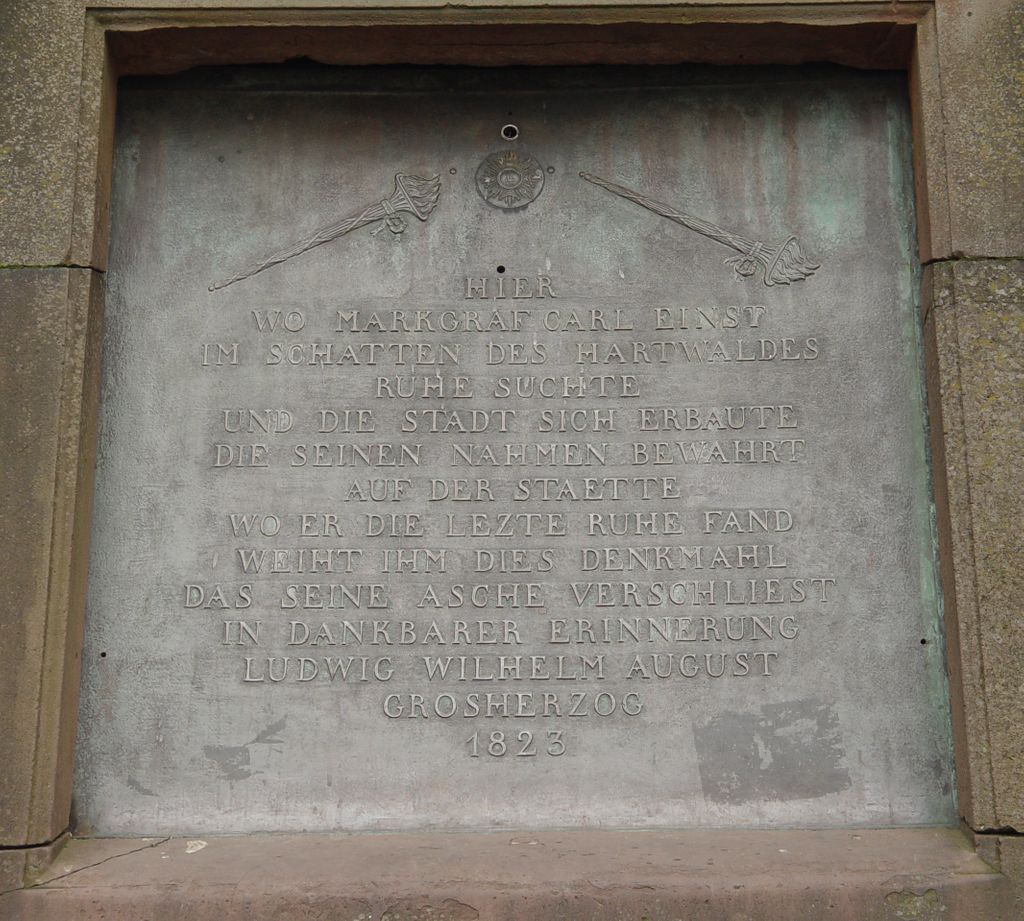
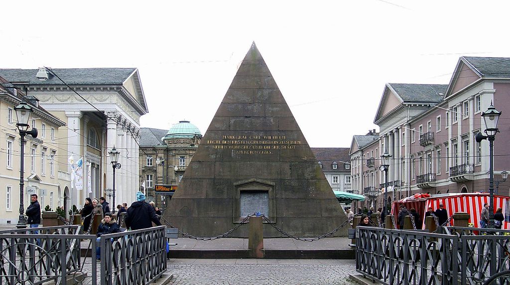
| Description | : | Built 1823-1825 over the crypt of the former Concordia Church, which was torn down in 1807, this tomb is a symbol of the city of Karlsruhe and is 6.81 meters tall. Die 6,81 Meter hohe Pyramide aus rotem Sandstein wurde von 1823 bis 1825 über der Grabgruft des Stadtgründers Markgraf Karl Wilhelm von Baden-Durlach auf dem zentralen Marktplatz erbaut. Sie ist eines der Wahrzeichen der Stadt. Bis 1807 stand an dieser Stelle die Konkordienkirche. |
frequently asked questions (FAQ):
-
Where is Karlsruher Pyramide?
Karlsruher Pyramide is located at Marktplatz / Karl-Friedrich-Straße 1 Karlsruhe, Stadtkreis Karlsruhe ,Baden-Württemberg , 76133Germany.
-
Karlsruher Pyramide cemetery's updated grave count on graveviews.com?
0 memorials
-
Where are the coordinates of the Karlsruher Pyramide?
Latitude: 49.0092200
Longitude: 8.4039400
Nearby Cemetories:
1. Evangelische Stadtkirche Karlsruhe
Karlsruhe, Stadtkreis Karlsruhe, Germany
Coordinate: 49.0085380, 8.4044580
2. Alter Friedhof Karlsruhe
Karlsruhe, Stadtkreis Karlsruhe, Germany
Coordinate: 49.0066680, 8.4165160
3. Jüdischer Friedhof an der Kriegsstraße Karlsruhe
Karlsruhe, Stadtkreis Karlsruhe, Germany
Coordinate: 49.0053000, 8.4184528
4. Großherzogliche Grabkapelle Karlsruhe
Karlsruhe, Stadtkreis Karlsruhe, Germany
Coordinate: 49.0198590, 8.4201550
5. Orthodoxer jüdischer Friedhof Karlsruhe
Karlsruhe, Stadtkreis Karlsruhe, Germany
Coordinate: 49.0144700, 8.4307300
6. Friedhof Beiertheim
Beiertheim, Stadtkreis Karlsruhe, Germany
Coordinate: 48.9944648, 8.3864104
7. Neuer jüdischer Friedhof Karlsruhe
Karlsruhe, Stadtkreis Karlsruhe, Germany
Coordinate: 49.0148300, 8.4317200
8. Hauptfriedhof Karlsruhe
Karlsruhe, Stadtkreis Karlsruhe, Germany
Coordinate: 49.0174620, 8.4354290
9. Alter Friedhof Bulach
Bulach, Stadtkreis Karlsruhe, Germany
Coordinate: 48.9885000, 8.3801000
10. Friedhof Rintheim
Rintheim, Stadtkreis Karlsruhe, Germany
Coordinate: 49.0163421, 8.4465934
11. Friedhof Oberreut
Oberreut, Stadtkreis Karlsruhe, Germany
Coordinate: 48.9885793, 8.3690911
12. Friedhof Mühlburg
Mühlburg, Stadtkreis Karlsruhe, Germany
Coordinate: 49.0150000, 8.3561000
13. Friedhof Bulach
Bulach, Stadtkreis Karlsruhe, Germany
Coordinate: 48.9839600, 8.3742300
14. Friedhof Grünwinkel
Grünwinkel, Stadtkreis Karlsruhe, Germany
Coordinate: 49.0065000, 8.3545000
15. Friedhof Nordweststadt
Nordweststadt, Stadtkreis Karlsruhe, Germany
Coordinate: 49.0342000, 8.3628000
16. Friedhof Rüppurr
Rüppurr, Stadtkreis Karlsruhe, Germany
Coordinate: 48.9709000, 8.3996200
17. Friedhof Durlach-Aue
Durlach, Stadtkreis Karlsruhe, Germany
Coordinate: 48.9871550, 8.4546440
18. Gefallenendenkmal Rüppurr
Rüppurr, Stadtkreis Karlsruhe, Germany
Coordinate: 48.9685350, 8.4022270
19. Friedhof Hagsfeld
Hagsfeld, Stadtkreis Karlsruhe, Germany
Coordinate: 49.0274956, 8.4616035
20. Südfriedhof Neureut
Neureut, Stadtkreis Karlsruhe, Germany
Coordinate: 49.0463810, 8.3718930
21. Friedhof Daxlanden
Daxlanden, Stadtkreis Karlsruhe, Germany
Coordinate: 49.0069000, 8.3386000
22. Nordfriedhof Neureut
Neureut, Stadtkreis Karlsruhe, Germany
Coordinate: 49.0514237, 8.3828918
23. Neuer Friedhof Wolfartsweier
Wolfartsweier, Stadtkreis Karlsruhe, Germany
Coordinate: 48.9739589, 8.4492275
24. Alter Friedhof Wolfartsweier
Wolfartsweier, Stadtkreis Karlsruhe, Germany
Coordinate: 48.9751000, 8.4520000