
| Memorials | : | 0 |
| Location | : | Rüppurr, Stadtkreis Karlsruhe, Germany |
| Coordinate | : | 48.9685350, 8.4022270 |
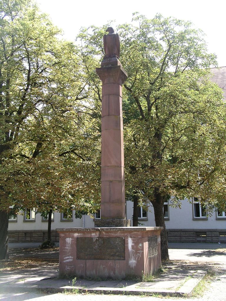
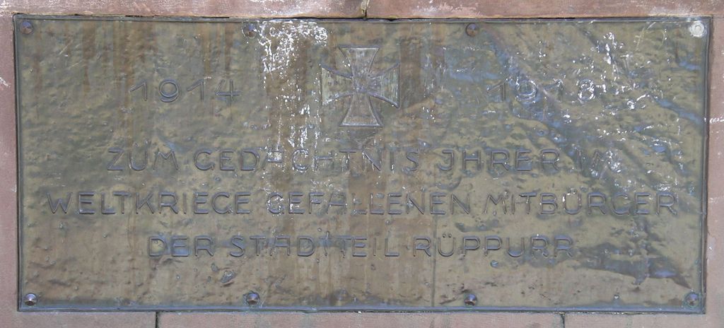
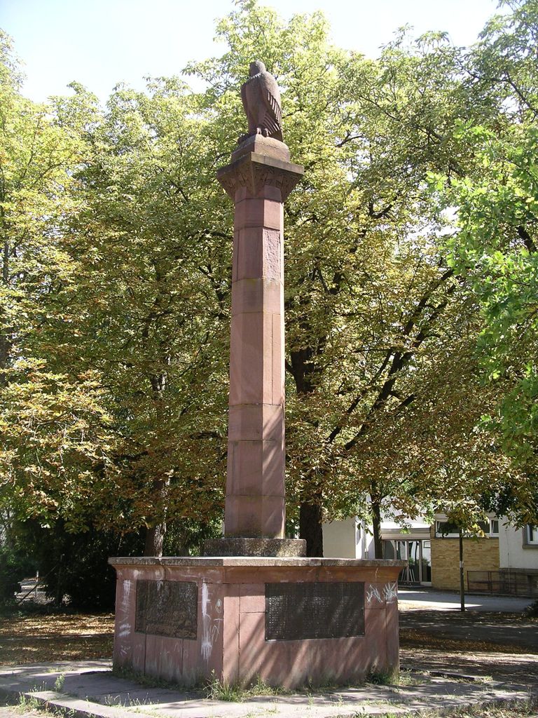
| Description | : | Denkmal für die im ersten Weltkrieg gefallenen Bürger von Rüppurr. Memorial for citizens of Rüppurr KIA or MIA at WWI. Inschrift / Inscription: 1914 ✠ 1918 ZUM GEDÄCHTNIS JHRER IM WELTKRIEGE GEFALLENEN MITBÜRGER DER STADTTEIL RÜPPURR |
frequently asked questions (FAQ):
-
Where is Gefallenendenkmal Rüppurr?
Gefallenendenkmal Rüppurr is located at Riedstraße Rüppurr, Stadtkreis Karlsruhe ,Baden-Württemberg , 76199Germany.
-
Gefallenendenkmal Rüppurr cemetery's updated grave count on graveviews.com?
0 memorials
-
Where are the coordinates of the Gefallenendenkmal Rüppurr?
Latitude: 48.9685350
Longitude: 8.4022270
Nearby Cemetories:
1. Friedhof Rüppurr
Rüppurr, Stadtkreis Karlsruhe, Germany
Coordinate: 48.9709000, 8.3996200
2. Friedhof Ettlingen
Ettlingen, Landkreis Karlsruhe, Germany
Coordinate: 48.9491000, 8.4151000
3. Friedhof Bulach
Bulach, Stadtkreis Karlsruhe, Germany
Coordinate: 48.9839600, 8.3742300
4. Alter Friedhof Bulach
Bulach, Stadtkreis Karlsruhe, Germany
Coordinate: 48.9885000, 8.3801000
5. Alter Friedhof Ettlingen
Ettlingen, Landkreis Karlsruhe, Germany
Coordinate: 48.9437700, 8.4103900
6. Friedhof Beiertheim
Beiertheim, Stadtkreis Karlsruhe, Germany
Coordinate: 48.9944648, 8.3864104
7. Friedhof Oberreut
Oberreut, Stadtkreis Karlsruhe, Germany
Coordinate: 48.9885793, 8.3690911
8. Neuer Friedhof Wolfartsweier
Wolfartsweier, Stadtkreis Karlsruhe, Germany
Coordinate: 48.9739589, 8.4492275
9. Alter Friedhof Wolfartsweier
Wolfartsweier, Stadtkreis Karlsruhe, Germany
Coordinate: 48.9751000, 8.4520000
10. Friedhof Ettlingenweier
Ettlingenweier, Landkreis Karlsruhe, Germany
Coordinate: 48.9314000, 8.3909000
11. Jüdischer Friedhof an der Kriegsstraße Karlsruhe
Karlsruhe, Stadtkreis Karlsruhe, Germany
Coordinate: 49.0053000, 8.4184528
12. Friedhof Durlach-Aue
Durlach, Stadtkreis Karlsruhe, Germany
Coordinate: 48.9871550, 8.4546440
13. Alter Friedhof Karlsruhe
Karlsruhe, Stadtkreis Karlsruhe, Germany
Coordinate: 49.0066680, 8.4165160
14. Evangelische Stadtkirche Karlsruhe
Karlsruhe, Stadtkreis Karlsruhe, Germany
Coordinate: 49.0085380, 8.4044580
15. Karlsruher Pyramide
Karlsruhe, Stadtkreis Karlsruhe, Germany
Coordinate: 49.0092200, 8.4039400
16. Friedhof Hohenwettersbach
Hohenwettersbach, Stadtkreis Karlsruhe, Germany
Coordinate: 48.9646000, 8.4726000
17. Friedhof Grünwettersbach
Grünwettersbach, Stadtkreis Karlsruhe, Germany
Coordinate: 48.9572302, 8.4719305
18. Friedhof Grünwinkel
Grünwinkel, Stadtkreis Karlsruhe, Germany
Coordinate: 49.0065000, 8.3545000
19. Orthodoxer jüdischer Friedhof Karlsruhe
Karlsruhe, Stadtkreis Karlsruhe, Germany
Coordinate: 49.0144700, 8.4307300
20. Neuer jüdischer Friedhof Karlsruhe
Karlsruhe, Stadtkreis Karlsruhe, Germany
Coordinate: 49.0148300, 8.4317200
21. Großherzogliche Grabkapelle Karlsruhe
Karlsruhe, Stadtkreis Karlsruhe, Germany
Coordinate: 49.0198590, 8.4201550
22. Hauptfriedhof Karlsruhe
Karlsruhe, Stadtkreis Karlsruhe, Germany
Coordinate: 49.0174620, 8.4354290
23. Friedhof Palmbach
Palmbach, Stadtkreis Karlsruhe, Germany
Coordinate: 48.9482740, 8.4803376
24. Friedhof Mühlburg
Mühlburg, Stadtkreis Karlsruhe, Germany
Coordinate: 49.0150000, 8.3561000