
| Memorials | : | 0 |
| Location | : | Tuckers Settlement, Perry County, USA |
| Coordinate | : | 37.7908280, -90.0065450 |
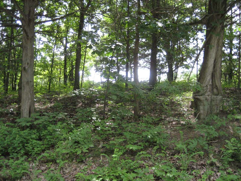
| Description | : | Keith Cemetery has returned to the forest. It is located about 30 feet off of Burnt Mill Road. It is near Minnith. (I don't know where Tucker's Settlement is located but I found a place called Tucker on an old map that was near the Cemetery. Tucker's Settlement was a place I could pick from the place list to create the cemetery. Minnith and Cedar Fork were not given as an option.)Unless you can find someone who knows where the cemetery is located you will never find it. You could walk right through it and never know it was there.... Read More |
frequently asked questions (FAQ):
-
Where is Keith Cemetery?
Keith Cemetery is located at Tuckers Settlement, Perry County ,Missouri ,USA.
-
Keith Cemetery cemetery's updated grave count on graveviews.com?
0 memorials
-
Where are the coordinates of the Keith Cemetery?
Latitude: 37.7908280
Longitude: -90.0065450
Nearby Cemetories:
1. Cedar Fork Community Cemetery
Perryville, Perry County, USA
Coordinate: 37.7411100, -90.0081800
2. Christ the Savior Catholic Church Cemetery
Brewer, Perry County, USA
Coordinate: 37.7803000, -89.9274000
3. Brown Cemetery
Saint Marys Township, Perry County, USA
Coordinate: 37.8499985, -89.9606018
4. Saint John the Evangelist Catholic Church Cemetery
Lithium, Perry County, USA
Coordinate: 37.8327600, -89.8873360
5. Saint Rose of Lima Cemetery
Silver Lake, Perry County, USA
Coordinate: 37.6843987, -89.9907990
6. Mount Hope Cemetery
Perryville, Perry County, USA
Coordinate: 37.7261009, -89.8936005
7. Mary Queen of Heaven Mausoleum
Perryville, Perry County, USA
Coordinate: 37.7248100, -89.8935200
8. Vincentian Community Cemetery
Perryville, Perry County, USA
Coordinate: 37.7269578, -89.8888922
9. Saint Mary's of Barrens Cemetery
Perryville, Perry County, USA
Coordinate: 37.7247800, -89.8894400
10. Saint Mary Seminary
Saline Junction, Perry County, USA
Coordinate: 37.7267500, -89.8872560
11. Home Cemetery
Perryville, Perry County, USA
Coordinate: 37.7332993, -89.8677979
12. Saint Boniface Cemetery
Perryville, Perry County, USA
Coordinate: 37.7233009, -89.8713989
13. Preston Cemetery
Perry County, USA
Coordinate: 37.8025017, -89.8330994
14. McKinney Cemetery #2
Leighton, Estill County, USA
Coordinate: 37.9048280, -89.9048280
15. Kaskaskia Cemetery
Kaskaskia, Randolph County, USA
Coordinate: 37.9183006, -89.9338989
16. Immanuel Lutheran Cemetery
Perryville, Perry County, USA
Coordinate: 37.7282982, -89.8460999
17. Saint Joseph Cemetery
Highland, Perry County, USA
Coordinate: 37.6598050, -89.8947720
18. Friedenberg Peace Lutheran Cemetery
Friedenberg, Perry County, USA
Coordinate: 37.7092018, -89.8292007
19. McDowell-Lenz Cemetery
St. Francois County, USA
Coordinate: 37.6810989, -90.1671982
20. Whitewater Christian Cemetery
Perryville, Perry County, USA
Coordinate: 37.6304817, -90.0860901
21. Old Kaskaskia Cemetery
Kaskaskia, Randolph County, USA
Coordinate: 37.9574630, -89.9229240
22. Southern Illinois Penitentiary Cemetery
Menard, Randolph County, USA
Coordinate: 37.9140210, -89.8383510
23. Crains Island Cemetery
Rockwood, Randolph County, USA
Coordinate: 37.8617168, -89.7953929
24. Yount Community Cemetery
Yount, Perry County, USA
Coordinate: 37.6062500, -90.0396800