
| Memorials | : | 0 |
| Location | : | Kingswear, South Hams District, England |
| Coordinate | : | 50.3566200, -3.5630800 |
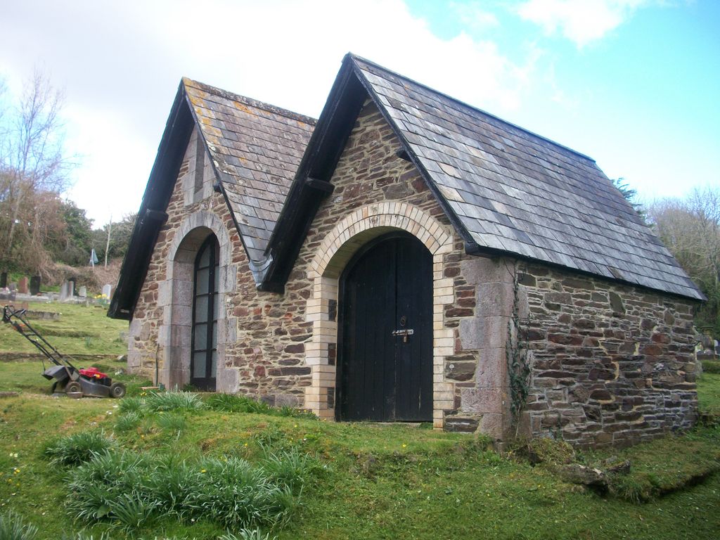
| Description | : | After a parish meeting on, 1st august 1882. It was decided to provide the parish with a burial ground, as the Churchyard was nearly full. An acre and a half was purchased in April 1884 from Mr Richard Roberts of Hoodown for £240. It was decided in 1885 that a Mortuary for bodies prior to interment should be provided. |
frequently asked questions (FAQ):
-
Where is Kingswear Cemetery?
Kingswear Cemetery is located at Brixham road Kingswear, South Hams District ,Devon , TQ6 0BNEngland.
-
Kingswear Cemetery cemetery's updated grave count on graveviews.com?
0 memorials
-
Where are the coordinates of the Kingswear Cemetery?
Latitude: 50.3566200
Longitude: -3.5630800
Nearby Cemetories:
1. Saint Thomas of Canterbury
Kingswear, South Hams District, England
Coordinate: 50.3484110, -3.5724130
2. Saint Saviour
Dartmouth, South Hams District, England
Coordinate: 50.3511390, -3.5790160
3. St Petrox Churchyard
Dartmouth, South Hams District, England
Coordinate: 50.3435177, -3.5705902
4. St. Clements Townstal Churchyard
Dartmouth, South Hams District, England
Coordinate: 50.3520700, -3.5911100
5. Longcross Cemetery
Dartmouth, South Hams District, England
Coordinate: 50.3489940, -3.5973650
6. St. Mary's Churchyard
Brixham, Torbay Unitary Authority, England
Coordinate: 50.3861660, -3.5195580
7. St Peter's Churchyard
Stoke Fleming, South Hams District, England
Coordinate: 50.3233750, -3.6002270
8. Brixham Nonconformist Cemetery
Brixham, Torbay Unitary Authority, England
Coordinate: 50.3867700, -3.5179900
9. St Mary & St Gabriel Churchyard
Stoke Gabriel, South Hams District, England
Coordinate: 50.4027900, -3.6207100
10. Cornworthy Parish Chapel Church
Cornworthy, South Hams District, England
Coordinate: 50.3880000, -3.6583000
11. St Mary the Virgin Churchyard
Collaton St Mary, Torbay Unitary Authority, England
Coordinate: 50.4304300, -3.6005090
12. St David's Churchyard
Ashprington, South Hams District, England
Coordinate: 50.4023200, -3.6637600
13. St. John The Baptist Churchyard
Paignton, Torbay Unitary Authority, England
Coordinate: 50.4368000, -3.5693300
14. Paignton Cemetery
Paignton, Torbay Unitary Authority, England
Coordinate: 50.4360560, -3.5821130
15. St. James' Churchyard
Slapton, South Hams District, England
Coordinate: 50.2931430, -3.6561920
16. St. Mary the Virgin Churchyard
Berry Pomeroy, South Hams District, England
Coordinate: 50.4368790, -3.6505430
17. St Peter Churchyard
Harbertonford, South Hams District, England
Coordinate: 50.3931400, -3.7127600
18. St. John the Evangelist
Bridgetown, South Hams District, England
Coordinate: 50.4295400, -3.6789000
19. Slapton Sands Memorial
Torcross, South Hams District, England
Coordinate: 50.2686958, -3.6524391
20. St. John the Baptist Churchyard
Marldon, South Hams District, England
Coordinate: 50.4608700, -3.5984100
21. St. Michael & All Angels Churchyard
Stokenham, South Hams District, England
Coordinate: 50.2733380, -3.6735470
22. St. Mary's Churchyard
Totnes, South Hams District, England
Coordinate: 50.4318190, -3.6877720
23. Totnes Priory
Totnes, South Hams District, England
Coordinate: 50.4318610, -3.6878700
24. Torre Churchyard
Torquay, Torbay Unitary Authority, England
Coordinate: 50.4685963, -3.5382016